


 By Pepper Parr
July 11, 2016
BURLINGTON, ON
And so we are going to grow Up, Smart and Beautiful – which is the tag line for what most of us understand as intensification.
How far up we go and where that up takes place is what a lengthy Committee of the Whole was about Thursday afternoon.
Council was assured that the planners knew where that “up” growth should take place and where is won’t take place.
The policies in the existing Official Plan are intended to guide the review of Official Plan Amendments involving a proposed increase in density.
These policies generally assist staff to review these applications on a site-specific basis but lack the required supporting policy framework that ensures that the proposal conforms to a broader city-wide vision and will support other important community and city-building objectives contained with the Official Plan and Council’s Strategic Plan.
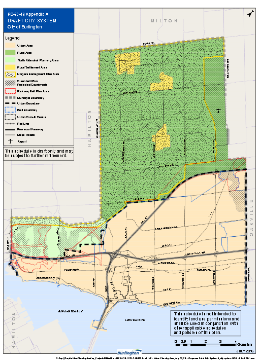
This is the vision – a clear separation between rural and urban.
Without a city wide-wide vision, intensification can quickly become sporadic and create many challenges for the city including:
• limiting opportunities to concentrate growth in key under-utilized areas which have the potential to be major sources of new growth and investment;
• creating the potential for proponent driven intensification proposals in established neighbourhood areas of the city;
• resulting in the sporadic allocation of limited financial resources for development specific infrastructure and/or community infrastructure upgrades/investments; and
• not achieving key goals and objectives of the Official Plan, Places to Grow and Strategic Plan.
In 2008, the city’s first intensification framework was developed and endorsed by city Council. This strategy was primarily intended to form the basis for the development of new mixed use land use designations in the Official Plan and to identify the city’s capacity for population growth as part of the Region’s 2031 growth allocation process. However, the strategy and associated mapping were not incorporated as part of the current Official Plan.
As of March 2016, 72% of proposed residential units since 2006 which are either currently under review by city staff/under appeal to the Ontario Municipal Board, or have been approved by city staff but for which a Building Permit has not yet been issued, were located outside of the intensification areas identified through the city’s previous 2008 framework.
What that seems to say is that developers paid no attention to the Official Plan and the city let them get away with.
“Given current development trends since the development of the 2008 intensification strategy, staff believe that action must be taken to establish a comprehensive vision for intensification in the city through the Official Plan.”
Proposed Direction: Intensification Framework
A new city-wide Intensification Framework is proposed as part of the current Official Plan Review that will build upon Council’s new Strategic Plan and serve to provide greater clarity and direction to the public, city staff and other levels of government as to where and how the city plans to grow and intensify over time. More specifically, the new framework will have four key objectives:
1. serve as a filter through which privately initiated Official Plan amendments for increased density are considered and evaluated to ensure that growth is being directed to priority areas including key under-utilized mixed use and transit station areas;
2. provide the basis for the development of population and jobs growth capacity projections which will inform the forthcoming 2041 growth allocations by the Region of Halton;
3. ensure coordination amongst various city departments and other levels of government and service providers with respect to the efficient and timely focusing of investment/upgrades in infrastructure (including water and wastewater servicing, transit, utilities etc.) and community infrastructure (including parks, community facilities and public realm) which may required to support intensification and long-term growth; and
4. provide greater opportunities to accommodate a variety of housing forms that can serve the needs of a broad demographic in terms of tenure, affordability and access to services and transit.
The following sections will identify how the proposed Intensification Framework will achieve these objectives by outlining the proposed details/structure of the framework, how the proposed framework will be implemented and also identify how the framework will serve to inform future city initiatives related to intensification.
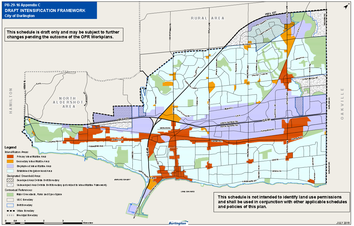
The proposed framework will achieve its objectives by establishing four key areas:
Primary Intensification Areas,
Secondary Intensification Areas,
Employment Intensification Areas
Established Neighbourhood Areas.
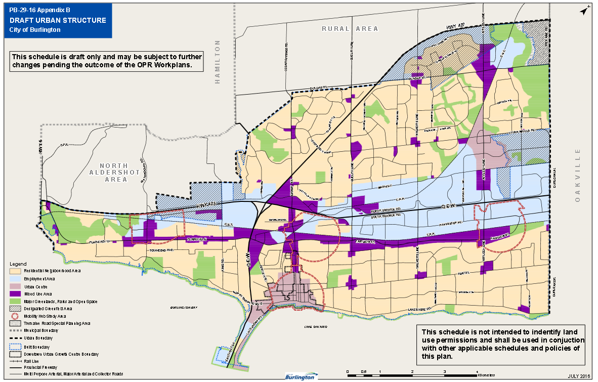
For each area, the Official Plan will contain objectives and policies that, while maintaining development permissions provided through the underlying land use designations, will serve to establish clear expectations for the scale and type of intensification that is expected within each area and provide greater direction when evaluating proponent driven Official Plan amendments for increased density. The high-level geographies, objectives and policies of each area are outlined below:
The Primary Intensification Area will be comprised of major nodes and corridors, which may include various residential, mixed use, commercial or employment land uses in areas which have the greatest potential to accommodate intensification including: the city’s Urban Growth Centre (UGC); mixed use areas of the Uptown Urban Centre; the Aldershot, Burlington and Appleby Mobility Hubs; the Plains Road/Fairview Street Urban Corridor; the Brant Street Urban Corridor and aging Neighbourhood Centres located south of the QEW
This is a draft document.
Primary Intensification Areas will focus on the intensification of under-utilized mixed use and employment areas (including Mobility Hubs) which have the greatest potential to accommodate significant population and employment growth and foster the development of pedestrian and transit-oriented neighbourhoods.
Growth within Primary Intensification Areas will account for a majority of the city’s growth over the planning horizon of the Official Plan and create a network of density that will support higher-order/frequent transit opportunities.
Policies for the Primary Intensification Area will require new developments to achieve intensification and promote developments which propose significant population/employment growth to locate in the Primary Intensification Areas to ensure that proposed redevelopments make the most of the development potential these areas offer. In addition, policies will ensure that these areas are planned to develop as complete communities and that Primary Intensification Areas are a focus for city, Regional and Provincial investment/upgrades to infrastructure and community infrastructure which may be needed to support significant population and job growth in these areas.
Secondary Intensification Areas will be comprised of commercial/mixed use designated areas and generally vacant sites which are not located within a Primary or Employment Intensification Areas and which are located immediately adjacent to an arterial street. In addition, staff propose that sites containing publicly-funded schools be generally identified as forming part of the Secondary Intensification Area in order to recognize potential redevelopment/intensification needs on these sites over the long-term which may not conform to the traditional residential land use designations applied to these sites.
Secondary Intensification Areas will consist of areas which may contain limited, site specific opportunities for intensification over the planning horizon of the Official Plan. However, to ensure the Primary Intensification Areas remain the primary focus for significant intensification and infrastructure and community infrastructure investment, these areas will not be intended to intensify at a scale or intensity equal to that of the Primary Intensification Area. As such, Secondary Intensification Areas will not be intended to accommodate a majority of the city’s growth to 2031.
In order to meet the intent of the Secondary Intensification Areas, policies will include criteria to evaluate intensification proposals which involve an Official Plan Amendment for increased density. The criteria will focus on the proposed scale and intensity of the proposed development to ensure that the proposal will not result in significant unplanned population growth beyond that currently permitted under a site’s existing Official Plan permissions and that the proposal will not require infrastructure/community infrastructure investments/upgrades in order to be accommodated.
This will provide staff and Council with greater control and predictability that development proposals involving significant population and employment growth will be focused/directed towards the Primary Intensification Areas. In addition, this will ensure that financial resources for potential infrastructure investment/upgrades required to accommodate growth are not being redirected to areas outside of the Primary Intensification Areas.
Established Neighbourhood Areas
Established Neighbourhood Areas will be comprised of existing, predominantly residential neighbourhoods (including areas designated as Residential Low, Medium or High Density) as well as small neighbourhood-oriented commercial sites which are not located on an arterial street.
This is a draft document.
Established Neighbourhood Areas will be intended to accommodate existing development, redevelopment and intensification opportunities which are already currently permitted through a site’s Official Plan land use designation. As such, Established Neighbourhood Areas will not be considered essential towards achieving population/employment growth to 2031 and beyond.
In order to maintain the stability of the Established Neighbourhood Areas and limit the potential for the introduction of significant and unplanned intensification proposals into these areas, policies will be introduced that prohibit privately initiated Official Plan amendments for increased density beyond that permitted through the underlying land use designation.
As a result, only the following forms of intensification would be permitted within the Established Neighbourhood Area:
Redevelopment/infill in accordance with Official Plan land use permissions;
Consents to Sever;
Plans of Subdivision; and
Accessory Dwelling Units (e.g. second suites, including detached units).
This limitation would not prevent or preclude the potential for redevelopment or intensification of sites within the Established Neighbourhood Area but rather provide greater certainty that any proposals will be in keeping with the existing permissions provided through the site’s Official Plan land use designation and compatible with the neighbourhood’s existing built form, density, and scale.
Employment Intensification Areas
The Employment Intensification Areas will be comprised of areas identified as city or Regional ‘Areas of Employment’ as identified at the conclusion of the city’s Municipal Comprehensive Review. However, this will not include employment designated areas located in undeveloped areas outside of the built boundary as the proposed Intensification Framework is intended to apply only to developed areas where redevelopment and intensification would occur within an existing developed area context.
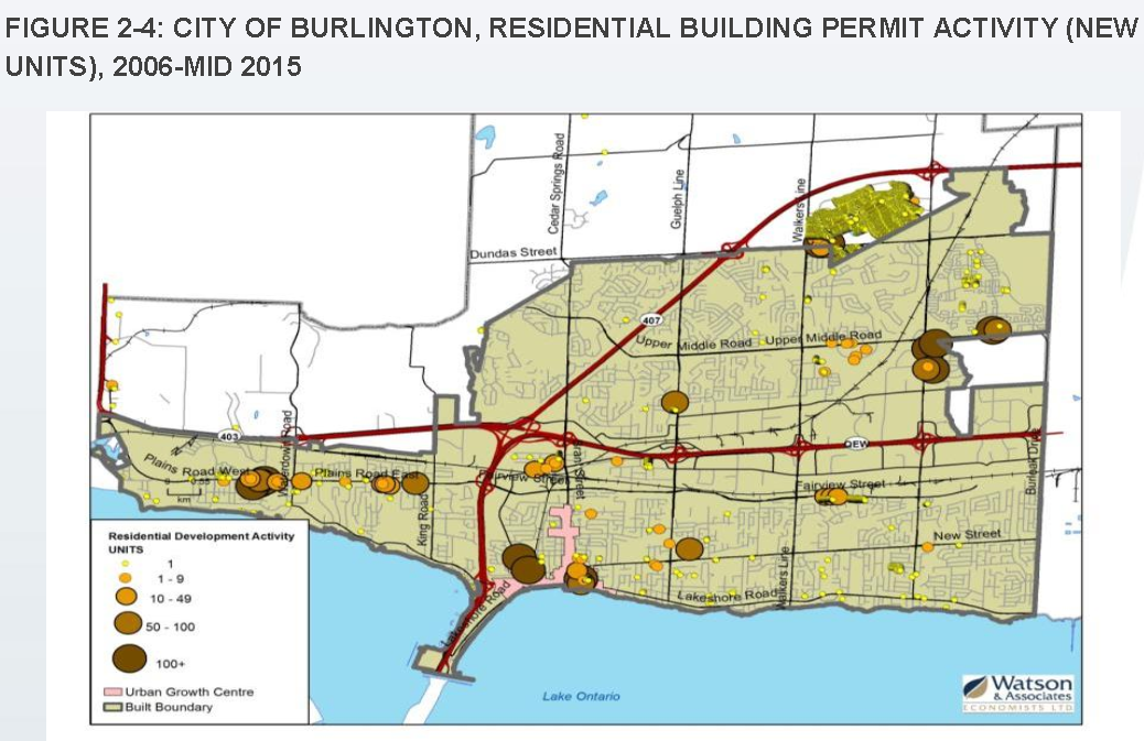
This is where the residential housing was built.
While not forming part of the Intensification Framework, employment designated lands within undeveloped areas of the city will continue to be governed by the underlying land use designations and policies of the Official Plan and will continue to form part of the city’s employment land inventory pending the outcome of the city’s Municipal Comprehensive Review.
The Employment Intensification Area is intended to capture employment lands located within developed areas which have the potential to accommodate further intensification and job growth to 2031 and beyond.
Within Employment Intensification Areas, staff generally believe that existing Official Plan permissions/policies along with the implementation of Council endorsed policy directions provided through the Employment Lands Direction Report will ensure that the Employment Intensification Area can continue to provide substantial opportunities for future intensification and job growth. A new policy is proposed that will promote significant employment intensification proposals to be located in areas which are in close proximity to transit routes and/or major, multi-purpose or minor arterial streets to ensure these proposals are adequately served by the city’s transportation network. In addition, staff may review the need for any additional policies pending the outcome of the city’s current Municipal Comprehensive Review for employment lands.
Council, meeting as a Standing Committee endorsed the report unanimously. It will get final approval at the next city council meeting.
It is a report that needs close study – policy for a long period of time is being put in place. The intensification targets will get written into the Official Plan – which both staff and council would like to see as something that has stronger teeth to it.
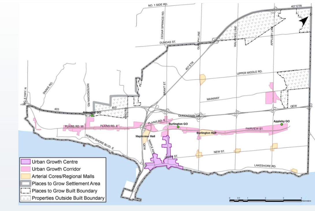
This is a map of the 2008 intensification framework.
The section of the staff report that told of the “72% of proposed residential units since 2006 were located outside of the intensification areas identified through the city’s previous 2008 framework” is troubling.
There will be more to say about intensification – right now it is Up, Smart and Beautiful as the city decides to Grow Bold.


And Burlington will no longer be THE place to live. Increased density = increased pressure on infrastructure and services, crime and so much more. If I wanted to live in Toronto, I would have moved there. This is hardly considered the burbs anymore.
It’s interesting how people that were most vocal against urban sprawl and in support of the Greenbelt blocking any opportunity for urban expansion seem to be surprised that the city is now forced to build “Up”. Seriously, what did you think was going to happen? I’m sorry to say, but the low-density Burlington oasis that you pictured in your head will look like downtown Toronto in just a few decades. Look at Mississauga 20 years ago versus now. The area they built up around City Hall is almost unrecognizable. That’s our future. You’ll soon be getting exactly what you asked for.
The plan is to eventually intensity “all public schools” and any area “immediately adjacent to an arterial street.” It’s hardly limited or controlled growth. There is nothing in the staff report about “Smart” or “Beautiful” growth its just “Up” and almost every place.
Yep, high density, and overcrowding, is where Burlington’s future belongs now. Shoe box size apts, at sky high prices. Ain’t it grand?