


 By Staff
December 8th, 2020
BURLINGTON, ON
The City of Burlington Community Planning Department is in receipt of the information package, dated, October 27, 2020 as circulated electronically by the proponent’s consultant planner.
The ARA package included an Agency Utility Letter, including copies of all technical reports/studies and plans related to the Application, a copy of the Notice of Application for a License (Form 1), and Notice of Public Information Session (Form 2).
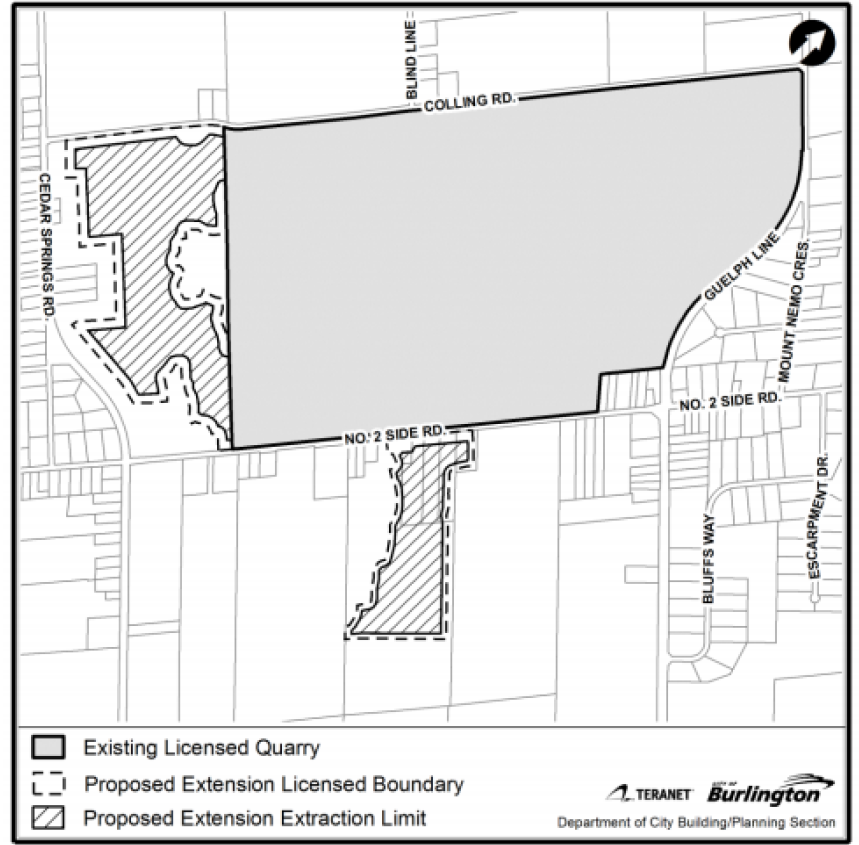
The Community Planning Department is actively engaged in the review of applicable land use development applications, including amendments to the Niagara Escarpment Plan, Region of Halton Official Plan and City of Burlington Official Plan as well as the application for Aggregate Resources Act (ARA) License, as it relates to the proposed extension of the Burlington Nelson Quarry.
A coordinated review through a Joint Agency Review Team (JART)(established in 2020) involves cross-consultation with agency partners (including, NEC, MNRF, Halton Region and Conservation Halton) and the applications remain in the early stages of review. It should also be noted that the Ministry of Natural Resources and Forestry (MNRF) cannot issue an Aggregate License without approval from the Niagara Escarpment Commission.
For these reasons, it is the opinion of the City of Burlington Community Planning Department that to review and comment on the specifics of the ARA License Application is premature given the anticipated duration of the review process and the relative early stage of analysis at this time. We therefore object to any form of ARA approval prior to a further evaluation and decision regarding land use impact, compatibility and appropriateness of the proposed development in the context of provincial and municipal (Region and City) policy.
In its initial review of the applications, City of Burlington staff and peer review consultants have also identified several areas concerning the proposal where either there has not been sufficient information or data provided; where analyses are not sufficiently coordinated with other key areas of review; or, where methodological bases of the information presented in the submitted plans, studies/reports remains undetermined or is inconsistent.
Five general theme areas of concern related to this information have been identified, as follows:
Effects on Surface Water Quantity and Quality
Improved coordination and cross-referencing between the applicant’s various disciplines is needed to perform a holistic review and analysis of issues related to groundwater, hydrology (quality and quantity) and impacts on surface water. This includes, but is not limited to, assessment and reporting on any/all water quality issues;
Confirmation of the suitability of the analytical tools selected by the applicant to simulate the existing and proposed drainage conditions and the accuracy of modeling techniques, assumptions and interpretation of results. This may include additional QA/QC of the monitoring data collected from gauging stations and clarity on the selection of locations for the gauging stations, as the data collected at these stations is applicable to the overall study;
Further assessment by the applicant of potential impacts to the municipal infrastructure and mitigate measures (roadside ditches along Colling Road) and predicted impacts to the surface water features resulting from the proposed quarry extension is needed;
A number of hydrologic features will essentially be lost, including an existing pond within the west expansion, as a result of the proposal and additional assessment is required by the applicant to demonstrate that the lost functions are appropriately replicated in the post-development conditions; Further review is needed by the applicant of the potential impacts to the Willoughby Creek flow regime and the effects on Medad Valley, as well as new surface water.
The conveyance features proposed within the subject lands and their impact on municipal infrastructure as a result of the expansion of quarry operations.
A mutually agreed upon Adaptive Management Plan is needed that addresses the technical comments of the Joint Agency Review Team (JART)(including a schedule for updating the plan), as are details also needed about the long-term rehabilitation plan and potential financial liabilities related to ongoing and future operations.
Natural Heritage Effects
There have been several natural heritage features with potential for impacts noted in the proponent’s submission that have been identified for further scoping within the study area.
These include provincially significant wetlands (outside of the 120 metre buffer for adjacent lands); significant wildlife habitat; significant woodlands; fish habitat (zone of influence to be confirmed); and landscape connectivity. Additional need for the evaluation of Species at Risk was also identified. The further consideration and analyses of these matters may involve the coordination and review of other technical studies and reports in the context of natural heritage, including potential and/or indirect impacts that may result from the proposed development (i.e. connections and linkages between natural heritage features, surface water features and groundwater).
Additional information is required to ensure the protection and reduced impacts of the proposed development on significant natural heritage resource areas, features and functions; particularly as it relates to mitigation and monitoring.
The assessment of long-term, cumulative impacts of future uses and long-term rehabilitation (after-use) plans may require additional clarification and data support.
Agricultural Effects and Existing Farming Practices
The Agricultural Impact Assessment (AIA) submitted by the applicant concludes that the permanent loss of the subject agricultural lands is inconsequential, yet the analysis is not systematic and does not examine impacts relative to pressures on the agricultural system at a broader scale (i.e. climate change, demand for settlement area boundary expansions, aggregate extraction, cemetery lands etc.), nor does it address the cumulative effect of the incremental loss of a finite resource over time;
The agricultural lands within the southern study area have been characterized in the AIA as fragmented, implying lower value/viability. However, the overlapping natural features, limited rural residential uses, and passive recreational uses within the area are generally considered compatible and complementary uses in relation to agriculture. Further, in terms of land use designation, the area is contiguously mapped as prime agricultural lands. Therefore, a comprehensive AIA is required for these lands.
The AIA notes that the average parcel sizes are indicative of smaller, ‘hobby-sized’ farms, implying lower value/viability. The PPS, 2020 does not make a distinction for ‘hobby’ farms and section 2.3.3.2 notes that “In prime agricultural areas, all types, sizes and intensities of agricultural uses and normal farm practices shall be promoted and protected in accordance with provincial standards”.
The extent of soil disturbance within the western study area is presumed as beyond rehabilitation, according to the study. Insufficient information has been provided to validate this claim. The AIA speaks to the consideration of “another property located farther away” but does not provide any detail with respect to the evaluation of this alternative site in relation to the proposal.
The AIA notes that an expansion to an existing site is less detrimental to agriculture than a new site, based on the use of existing haul routes. Yet it does not assess the impacts associated with an intensification of the existing aggregate use, i.e. increased quarry traffic on existing haul routes, as well as the extension of the life of the quarry and the long-term disturbance to agricultural operations within the area.
The AIA notes that an open-water feature can provide benefits to the agricultural area by providing flood attenuation and fresh water for irrigation purposes, yet does not present supporting evidence identifying a need/demand for flood attenuation or irrigation within the subject lands.
Human Health (Air Quality)
A technical peer review of the applicant’s Air Quality Study, as included with the application submission is ongoing, with particular focus on matters related to methodology, findings and conclusions associated with any potential air quality impacts of the proposed quarry extension.
Operational/Coordination
The City of Burlington expresses concern with the planned future for existing industrial land uses (i.e. processing facility) on the quarry lands and the prospect of the continuation of those activities in the context of an expanded quarry operation. There has not been consistent or adequate detail pertaining to the use of the existing quarry lands for an industrial use in the event that aggregate resource extraction ceases (or is substantially reduced) on that portion of the quarry operation and its resultant conformity with applicable legislation and policy related to the Niagara Escarpment Area. It should be noted that concerns have been raised by stakeholders with respect to the timelines of the receipt, review and comment on the ARA License Application and the change in format.
A Public Information Session (PIS) required as a component of the review process.
While the City recognizes and appreciates the rigour of provincial regulation pertaining to public consultation and the restrictions on public gatherings implemented to contain the spread of COVID-19 (as documented in the August 2020 Aggregate Resources Program Bulletin: Resuming Aggregate Application Timelines and Public Consultation under the Aggregate Resources Act (Post COVID-19)), issues of public access to this process persist.
While the City Community Planning Department understands that the prescribed format for information sessions is not established through regulation and the Ministry of Natural Resources and Forestry (MNRF) has provided guidance on alternate virtual public information sessions to facilitate verbal exchange between parties, the City Community Planning Department reasserts that maximum public disclosure and access is paramount.
At present, the format of the consultation described in the Notice of Public Information Session appears focused on a format that may solicit direct communication between the proponent and an interested individual rather than among and between the larger stakeholder community and the proponent.
A virtual public information session in a format that is widely available for a public exchange between all parties (simultaneously), and which is initiated and coordinated by the proponent, is technically possible, and should be a minimum requirement. The City of Burlington Community Planning Department appreciates the opportunity to provide comments in response to the circulation of the ARA License Application, and requests notification of any future meetings or updates on the review of this file.
The City of Burlington reserves the right to raise further issues as the review of these applications progresses.