


 By Staff
March 22nd, 2023
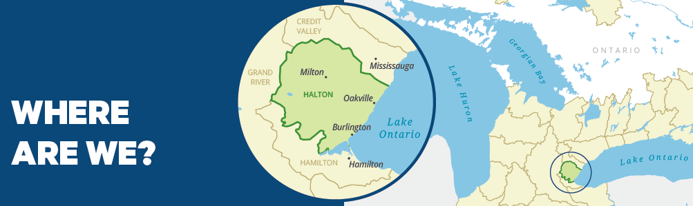
BURLINGTON, ON
What is a Watershed?
A watershed is an area of land drained by a creek or stream into a river which then drains into a larger body of water such as a lake. Everything in a watershed is connected. Our actions upstream can affect conditions downstream.
 Why Measure?
Measuring helps us better understand our watershed. We can target our work determine where work is needed and track progress. We measured: Groundwater Quality, Surface Water Quality and Forest Conditions
What is a watershed report card?
Ontario’s Conservation Authorities report on watershed conditions every five years. The watershed report cards use Conservation Ontario guidelines and standards developed by Conservation Authorities and their partners.
 Conservation Halton
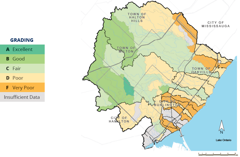
SURFACE WATER QUALITY – GRADE – C
Grades for surface water quality are based on chemical (phosphorus concentrations) and biological (benthic invertebrates) indicators of water quality across the watershed.
What Did We Find?
 • Grades ranged from A (Excellent) to F (Very Poor).
• Subwatersheds with lower scores (D to F) tend to be in agricultural or urban areas.
• Subwatersheds with higher scores (A to C) tend to be in areas with more natural cover, including higher amounts of forest cover.
• Ongoing efforts to improve stormwater management and increase the use of low impact
development (LID) practices will help to improve water quality.
• 9 subwatersheds saw improvements, receiving a higher grade than they had scored in the 2018 Watershed Report Card.
• 9 subwatersheds had more degraded conditions, receiving a lower grade than in 2018.
• 6 out of the 11 water chemistry stations sampled over the last 5 years had chloride concentrations above the water quality objective. These stations were within Sheldon, Fourteen Mile and Sixteen Mile Creeks.
Conservation Halton
GROUNDWATER QUALITY GRADE – A
Grades for groundwater quality are based on concentrations of nitrate + nitrite and chloride levels at 10 groundwater wells across the Conservation Halton watershed. Wells have been monitored for the past 21 years
What Did We Find?
• Grades ranged from A (Excellent) to F (Very Poor) with mostly A grades, which represent the groundwater conditions at the well locations only.
• Groundwater quality can vary significantly from site to site and be influenced by geology, land use, human activities, etc.
• Two wells (W004-1 and W030-1) exhibit naturally higher chloride concentrations due to proximity to shale bedrock.
• Two wells (W336-1 and W005-1) are showing impacts from human activities such as road salting and agricultural activities as they are higher in both chloride and nitrogen concentrations.
WHAT’S TRENDING?
As part of Conservation Halton’s Long-term Environmental Monitoring Program, staff have been collecting, analyzing, and reporting on environmental data for almost 20 years. Some of the most evident trends in our watershed include:
Water Quality:
Analysis of over 50 years of water quality data shows that chloride (salt) concentrations continue to increase across the watershed. In some watersheds, the values are more than double the limit considered safe for aquatic life. When snow melts, the salt applied to hard surfaces like roads and sidewalks in the winter enters waterways and groundwater recharge areas. Chloride can also be re-suspended during rain events, causing harmful effects into the summer months. Chloride, combined with the added stress of warming stream temperatures has an adverse impact on our streams, impacting habitat and stressing aquatic organisms. There is no current treatment for chloride removal from our environment.
Prevention is the key! Reducing salt application and protecting our waterways through streamside plantings and other nature-based climate solutions helps to reduce stream temperatures and protect water quality.
Invasive Species:
Ecosystems are under threat from invasive species. Invasive species are plants, animals, pests, and pathogens that out-compete native species when introduced to a new area. They often become predators, competitors, parasites, and carriers of disease for our native plants and animals. Analysis and results of forest health monitoring done by Conservation Halton at selected sites demonstrate that forests across the watershed are being drastically altered and damaged. Once established, invasive species are costly and difficult to remove. Planting native species, ensuring that plants and animals are not moved from one location to another and disposing of invasive species in the garbage (NOT the compost) protects biodiversity and helps to prevent spread.
WHAT IS OUR WATERSHED’S KEY ISSUE?
There are many issues affecting our environment from climate and land use changes to local habitat impairments or alterations. One concerning issue is pollution of our streams.
Pollution Of Our Streams:
• Chemical and physical pollution, including the warming of waterways, has significant impacts on water quality, and the species, including humans, that rely on clean water.
• Pollution comes from various sources across urban, residential, and agricultural landscapes and results from choices we make, such as whether to apply fertilizers to our home garden.
• During rain or snowmelt, pollutants and soils run off fields, roads, and yards and enter streams or are absorbed into the groundwater.
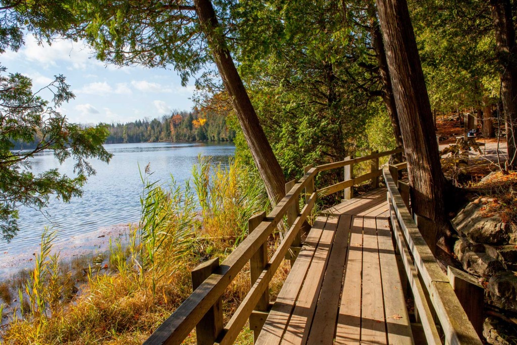
Walk around a lake that is in pristine condition. When scientists explored the bottom of the lake they found evidence of early Indigenous settlements.
What Actions Can You Take To Reduce Pollution In Our Streams?
• Conserve natural landscapes, especially wetlands and streamside vegetation, that naturally aid in removing pollutants.
• Reduce nutrients from entering waterways by implementing best management practices on your property.
• Prevent stormwater from entering streams by using low impact development and redirecting water to lawns and gardens.
• Get out and explore Conservation Halton parks and the natural areas around you. Appreciating and exploring nature is the first step in making wise choices to help protect it.
WHAT CAN BE DONE?
What Can your Community do?
• Support initiatives to improve stormwater management.
• Adopt low impact development practices to help reduce runoff.
• Direct development away from areas of environmental significance.
• Minimize salt use and explore new alternatives.
• Protect and connect wetlands and other natural heritage features.
• Support monitoring and restoration initiatives to track environmental change and improve conditions
What can agencies do?
• Evaluate the effectiveness of their environmental programs
and take steps to green their operations
• Work together to manage natural systems to protect and enhance connected natural habitats on the landscape
• Protect and create more urban greenspace to reduce stormwater, cool temperatures and provide healthy outdoor living and recreational opportunities for people

Discover more from Burlington Gazette - Local News, Politics, Community
Subscribe to get the latest posts sent to your email.
