


 By Pepper Parr
January 15th, 2025
BURLINGTON, ON
This is one of those projects where the citizens lost because the Planning Department didn’t do its job.

It was to be a community minutes away from the Aldershot GO station. Hone for more than 3000 families – not even a coffee shop in the immediate area.
The development is the last stage of the Station West development ADI built on Masonry Road, just east of Waterdown Road.
It is a huge development on land the Adi Group bought from Paletta International for a reported $14 million. It was a fantastic deal for the Adi people
It all started in 2015 in a church hall.On Wednesday, June 24, 2015 at the West Plains United Church there was a community meeting at which the city’s planning staff set out a proposal that had been submitted by the ADI Development Group for the development of land that was south of the rail line, east of Waterdown Road and immediately north of Masonry Road
It was a staff presentation and the first time the community got a look at what the developer had in mind. Using the language of the planner it was an application to subdivide a 5.09 hectare parcel of land located south of the CN Rail tracks on the east side of Waterdown Road.
The subdivision design includes a road running north/south, extending north from Cooke Boulevard, and a 3.08 hectare development block on the east side of the proposed road.
The proposed development for the development block includes 200 stacked townhouses, 64 standard town
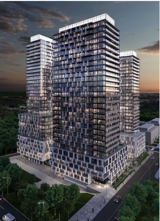
This latest application proposes to amend the Official Plan and Zoning Bylaw to permit a mixed-use development comprising three tall buildings with retail uses at ground level and residential uses above.
In the original proposal (2022): Building A (northwest corner of site) was 36 storeys tall including a 4-storey podium. Building B (southeast) was 26 storeys tall. Building C (southwest) was 36 storeys tall. Buildings B and C shared a three-story podium. The proposed buildings contained a total of 1,139 residential units and 231m2 of ground-level retail at the corner of Masonry Court and Cooke Blvd. 1,031 parking spaces were proposed within five levels of underground parking.
The location was originally going to be parkland – when the developer decided to make it a set of high-rise towers there was no one to speak for the people who were eventually going to live there.
In the revised proposal (2023): Building A (northwest) is 33 storeys tall including a 12-storey podium. Building B (southeast) is 29 storeys including a six-storey podium that steps down to three storeys on the north side. Building C (southwest) is 31 storeys including a six-storey podium.
The buildings are no longer connected to each other, and a plaza has been introduced at the ground level between Buildings B and C.
The total number of residential units has increased from 1,139 to 1,165. The total amount of retail floor area has increased from 231m2 to 495m2.
The total number of parking spaces has increased from 1,031 to 1,145 spaces within 6 underground parking levels.
The site of this portion of the Station West development was to be parkland – it didn’t work out that way. What parkland this community is going to have will be to the north where a stormwater pond is located.
For more detailed information about the proposed development, refer to the documents linked under “Revised Supporting Documents” below.
Members of the public can direct questions or comments about the proposed development to the Planner on File using the contact information below.
Related news stories:
The full story of a community that has the potential to be a problem community.
Where was the parkland supposed to be?

Discover more from Burlington Gazette - Local News, Politics, Community
Subscribe to get the latest posts sent to your email.

We should already know this by now – Adi is just not into parks.
On June 2024, City Council approved the applications for Official Plan Amendment and Zoning Bylaw Amendment for 1120 Cooke Blvd. At a statutory meeting on March 4, 2024, I delegated a number of comments.
There was no suggestion that the planning for this latest ADI proposal makes any effort to build into an MTSA guideline aiming for a complete community with diverse uses, and provision for human needs, however, Council approved it nonetheless. Someone appealed to OLT but subsequently dropped the appeal, and that freed up the City to legalize this approval.
Even a very brief look at the Provincial Growth Plan policy that this application must conform with is the goal of achieving Complete Communities; and protecting employment zones with at least 2 uses. The application states that it is mixed use, with 2 uses but the planned retail commercial is a mere 495 m2 in
only 1 building, out of 73,134 m2 residential in the 3 buildings proposed together – this is only 0.0068% of the GFA.
The ROPA 48 states that in MTSAs employment (jobs) utilization targets should consist of 20% with 80% people. Parking is too low to support a complete commercial base. This complete failure to build complete communities is a general feature of essentially all applications in the MTSA. There is no visible movement towards this policy, so we will never reach it.
Despite talk and promises, there is no place in the MTSA to buy the daily needs of life in the quantities needed by families in the densities being built. In particular, lack of parking and the City pushing a call to walk everywhere do not help.
Even at the densities specified – no commercial base is possible. 40k people clustered around an Aldershot GO station, gone all day, cannot support local businesses – period.
It’s a great day for Clappison’s corners – where-by their way of commercial building continues to help restore services driven out of Aldershot by poor development. The drive far away, to everything, Big-Box, Era of the Car, model is getting stronger here not weaker. Notice the congestion/gridlock on the Skyway.
Developers are selecting heights they know will overwhelm any existing usage. The business and residential in the MTSA can be very cheap relative – easy to get anything there when you exchange it for 25 and 35 stories of residential, with so-called Throw-away commercial”
Other policies noted by the Gazette in the application appear to skirt regard for building a healthy environment – there is now a just legalized public park block right beside the railway line and highway 403 to the North, and next to a storm water flood control pond to the West. Both are high sources of air emissions of many pollutants, and the pond is densely polluted from water sources. The water is a foul environment.
During Phase 1 of the ADI development, there was clear indication that a substantial area in the north- west corner would become a park and play area for the residents. As it turns out, by my observation, this area is now a substantial storm water catch basin area. No park or play area is visible. Greenspace – for
lounging and child’s play? No place to play and hang-out just leads to trouble.
Another noted problem, attributable to Adi going for the big highrise and money instead.
In many instances developers are allowed to pay a “park dedication fee in lieu” instead of actually providing parkland for the residents. Not having close access to a parkland type setting becomes difficult, for families with young children, and also the handicapped, to readily access a natural outdoor area for relaxation and recreational play. Where does this money go? The list of issues goes on, so where did Councilor Galbraith go – I never heard a word.
Isn’t there enough traffic on our already congested streets? A further almost 1,200 vehicles plus will bring the city to a standstill. Not to mention the pollution from all those vehicles. Is this what we really want in Burlington?
Dorothy, what we want and what we will be told by the OLT we will have a two very different things.The OLT does the Ford government ‘s bidding. The Ford government is way off its housing targets. So you can see where this is going.