


 By Pepper Parr
November 11th, 2024
BURLINGTON, ON
We knew that the July flooding was going to impact the 2025 budget – that was the reason given for the delay in getting the document out to the public.
So what is the Engineering department going to do to prevent the kind of experience we experienced in July.
Inspection seems to be where the focus will be. The plan seems to be a detailed inspection every five years – which doesn’t seem like enough. And what does an inspection actually consist of?
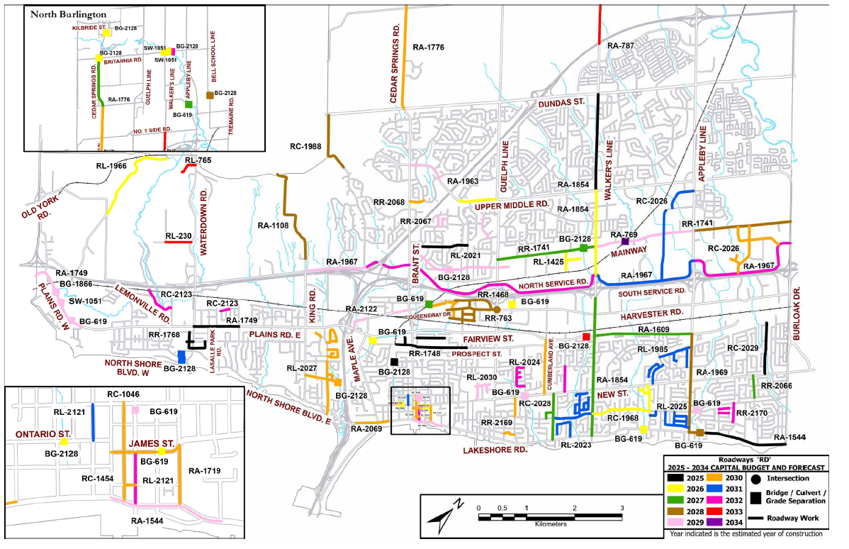
The creeks that carry the water that floods neighbourhoods when the banks overflow.
In a conversation with people who do this kind of work someone wondered why small drones weren’t used to zip up and down the problem creeks and see what, if any damage was done after a rain storm.

The city produces massive reports with more detail than Council members can absorb – there is little follow up on the detail – the public is left to just figure it out.
In the budget report they state: “This multi-year monitoring program will be used to confirm the effectiveness of prior erosion control projects, collect flow data, rain data and ground water data at various locations. The collected data will aid in determining the cause of flooding in certain areas and developing solutions to resolve these problems.”
Ok – so far.
Now what about the work to be done on specific creeks?
All area creeks study:
Previous Creek Inventory and Erosion Assessment Reports will be updated, to review and prioritize erosion sites. This study will provide updated priorities and budget allocations. Update occurs approximately every five years.

Spending of four to five million each year for the next four years is what the Engineering department are expecting. A total of $67 million in the next decade. There is probably not a lot of certainty to those numbers either
2025: Location=All urban area creeks
2030: Location=All urban area creeks
Future work on urban creeks
Erosion control repairs and creek restoration at various locations due to erosion or bank failure. The 2020 Creek Inventory and Erosion Assessment Study identified tertiary erosion sites, prioritizing them from 51 to 100. The upcoming Creek assessment study in 2025 will reassess these sites and update the priority list accordingly. In the 2026 Capital Budget and Forecast, high-priority erosion sites will be identified for construction.

2030: Detailed Design and construction of priority erosion sites
2031: Detailed Design and construction of priority erosion sites
Rural area culverts:
The program was initiated in 2009 to provide dedicated capital funding to culvert replacement in Conservation Halton regulated lands on an ongoing basis and as required.
This project also finances culvert replacements, as was recommended in the Culvert Inventory and Condition Assessment Report completed in 2020.
Each year 2-3 detailed designs are initiated for culverts within Conservation Halton regulated lands and 2-3 agency approved culverts are reconstructed.
 2025: Culvert Replacement at 3258 Walkers Line, Detailed Design of 2026 Culvert Replacements
2026: Culvert Replacement at 4335 No. 1 Side Road (AM ID 30864), Replacement of high priority culvert as identified via 2025 summer inspections
2027-2034: Replacement of high-priority culvert (potential replacements: 4225 No. 1 Side Road AM ID 30866, 4335 No. 1 Side Road AM ID 30865, 4356 No.1
Side Road AM ID 30863, or 3770 No.1 Side Road AM ID 30872) as identified via summer inspections. Inspections to inform priority replacement in future years.
Falcon Creek work:
A Class EA Study and detailed design will be required to address the erosion concerns.
Initial cost estimates have been provided before Class EA Study. Updated preliminary construction cost estimates will be provided during the Class EA Study, and again refined at the detailed design stage.
This project will help reduce sediment loading into Burlington Bay / Hamilton Harbour.
 2028: Class EA and Detailed Design
2031: Construction of creek works as per Class EA recommendations

Falcon Creek needs a lot of work. BRAG will be doing a separate article on this.
Our friends at BRAG are working on a deeper dive on this one. Environmental Assessments are expensive and seem to always require outside consultants. It’s going to take BRAG a couple of days to do their digging.
Falcon Creek Erosion Control (North Shore Boulevard to Hamilton Harbour)
Rambo Creek
There are several different sections of Rambo Creek that have been set out in the Storm Water spending
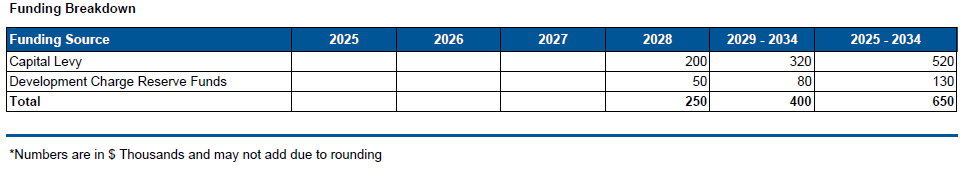
Rambo studies
Certain areas in the Rambo Creek Watershed are susceptible to flooding. These studies will be carried out to understand the cause of flooding and recommend mitigation.
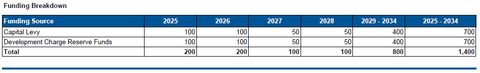
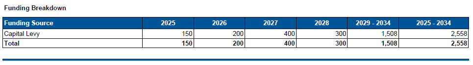
Funding Breakdown
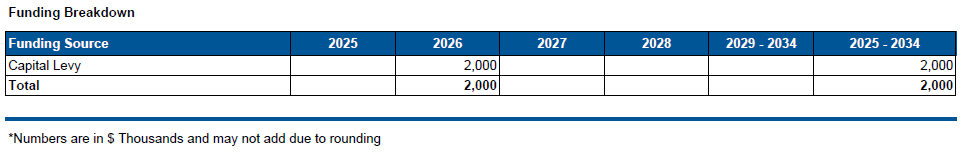
 Rambo behind the Brant Plaza (No Frills)
The plans to redevelop the No Frills Plaza on Brant Street will require major upgrades to the Rambo Creek. The plans call for a walking path beside the creek and a number of medium-height towers. A separate article will be done on this project.
A Class EA Study and detailed design will be required to address the erosion concerns.
Initial cost estimates have been provided prior to Class EA Study. Updated preliminary construction cost estimates will be provided during the Class EA Study, and again refined at the detailed design stage.
 2032: Class EA and Detailed Design
2033: Partial Construction Funding
2034: Construction of creek works as per Class EA recommendations
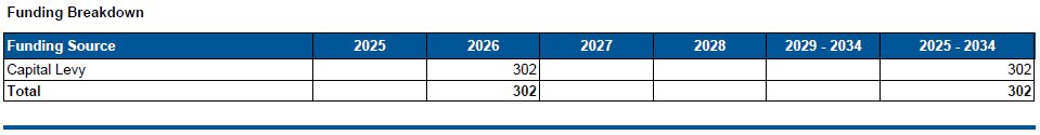
Rambo Victoria to Emerald – behind Brant Plaza
 Class Environmental Assessment (EA), Detailed Design and Construction of erosion control projects to be identified.
Sheldon Creek erosion
Project Description
A Class EA Study and detailed design will be required to address the erosion concerns.
Initial cost estimates have been provided prior to Class EA Study. Updated preliminary construction cost estimates will be provided during the Class EA Study, and again refined at the detailed design stage.
 2030: Class EA and Detailed Design
2031: Partial Construction Funding
2032: Construction of Approved Detailed Design
Minor work money every year
Project Description
Minor erosion control repairs at various locations due to erosion or bank failure. These projects are either identified in the Creek Inventory and Erosion
Assessment Reports have been identified as a result of storm events.
2025: Sheldon Creek behind Mullin Way (Priority 47)
2026: Rambo Creek adjacent to Brant Street Detailed Design (Priority 34), Tuck Creek South of Spruce Avenue Detailed Design (Priority 39)
2027: Tuck Creek adjacent to Lakeshore Road Detailed Design (Priority 35)
2028: Rambo Creek adjacent to Tyrell Road Detailed Design (Priority 37), Rambo Creek behind Cavendish Drive (Priority 45)
Minor inlet outlet drainage
Project Description
Minor infrastructure improvements are needed to improve drainage and reduce flooding. Typical projects include the redesign of inlet grates to reduce the chance of clogging and minor grading or storm sewer work to improve drainage and reduce flooding. Priorities are reviewed annually.
 2025-2034: Design or remediate local drainage improvements, including minor inlet-outlet repairs.
Stormwater ponds
City-owned storm water management (SWM) ponds require sediment removal. Funding is required for sediment surveys, preparation of contract documents, sediment removal, and disposal. Stormwater management infrastructure rehabilitation and water quality monitoring is also included.
Oil Grit Separators (OGS) are underground water quality control devices that are designed to trap sediment and oil/grease from the storm sewer system, resulting in cleaner water. This funding will also include inspection of all the Oil Grit Separators and clean-out works to restore the OGS designed sediment capacity.

2025: East Rambo Creek Cleanout Funding, SWM Pond 4 Sediment Clean Out, Sediment Surveys (SWM Pond 6, 9, 13, 24, 26)
2026: SWM Pond 11 Sediment Clean Out / higher priority Pond as identified in 2025 sediment surveys
2027: SWM Pond 24 Sediment Clean Out / higher priority Pond as identified in 2025 sediment surveys
2028-2034: Sediment clean out for high priority pond as identified in 2025 sediment surveys.
Tuck Creek mitigation
During the August 4, 2014 storm, there was considerable ravine flooding along Tuck Creek.
Approved Council report CW-09-15 recommended enhanced flood protection in the lower reaches of this watershed. This project will address Tuck Creek from north of New Street to south of Spruce Avenue. The required Flood Mitigation Class EA for this reach was completed in 2016.
Phase 3 – Spruce Avenue Culvert Upgrade and Channelization to be completed.
 2025: Spruce Avenue Culvert and Channelization Partial Construction Funding
2026: Spruce Avenue Culvert and Channelization Partial Construction Funding
2027: Spruce Avenue Culvert and Channelization Construction
The review of the spending set out in the Budget book has been known to Council members for some time and yet during that period of time when the Mayor was speaking with small groups of residents at ward-level meetings little, if any, mention was made of the costs the city faces due to flooding. Climate change is very real – but no one knows when the next storm is going to dump water on the city the way it did in July.
There is every reason to expect more of what took place last summer – as shown below.
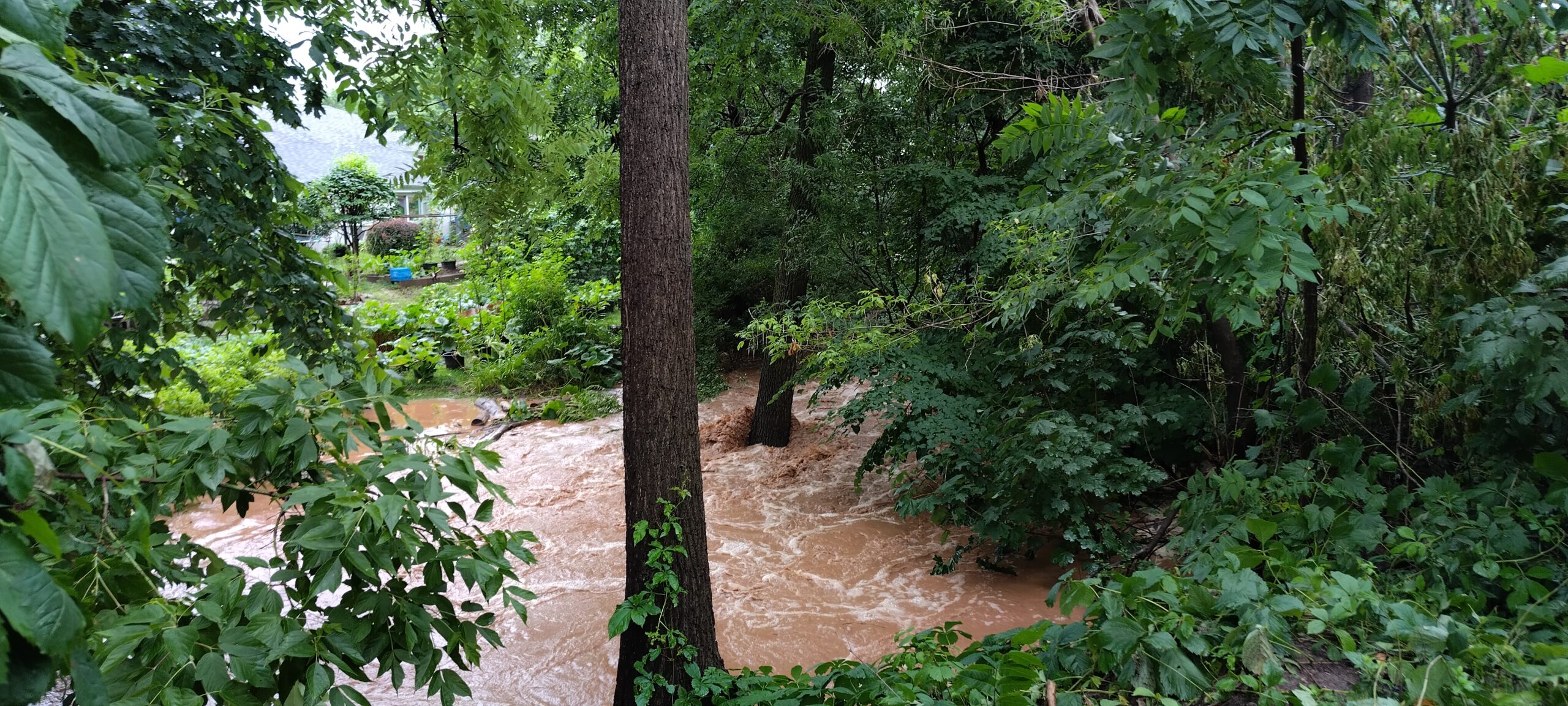
Rainwater was more than the catch basins could manage which led to water racing through properties.
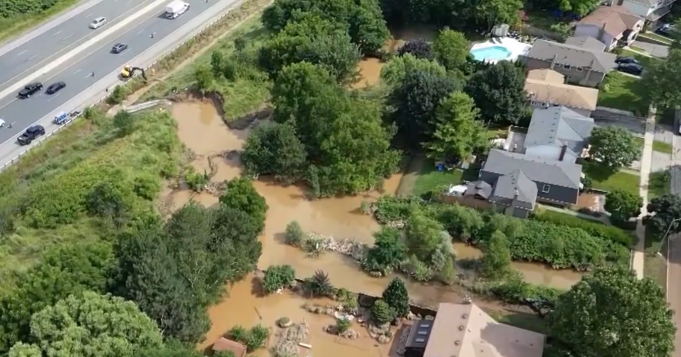
A blocked culvert prevented water that would have run through pipes under the 407 backup and damaged homes overlooking the toll highway

Discover more from Burlington Gazette - Local News, Politics, Community
Subscribe to get the latest posts sent to your email.

Loads of spending info but will it prevent a recurrence? What is the main cause of all the flooding, other than it rained alot. Was the flooding due to riverine versus urban water flows as Daintry suggests? More importantly if we have such a rainfall in 2025, will the same thing happen? I see nothing in the above that speaks to the contrary.
It is interesting that most of this report focusses on riverine flooding. As we know from the Provincial Auditor General’s report, 97% of flooding is urban flooding rather than 3% riverine flooding. Flood mitigation and climate change requires greenspace to absorb stormwater and slow the flow before it reaches the creeks. Attention to managing hardened surfaces relative to absorption through lot coverage, setbacks, boulevards, parks and the greenbelt assist with this. The City is currently working on the zoning for the City in response to the new Official Plan (2020). Hopefully they are considering climate change and updating accordingly.
The City is still working on the “To Do” list from 2014 and here we are again.