


 By Staff
April 1st, 2024
BURLINGTON, ON
Conservation Halton advises that Environment Canada is forecasting that a low pressure system will bring widespread precipitation across southern Ontario this week. Currently, local forecasts indicate that 25-50 mm of rain is possible on Tuesday and continue through Wednesday. As temperatures cool towards Thursday, the rain may change to wet snow. The anticipated rainfall combined with increased runoff from wet soil conditions will result in elevated water levels in rivers and streams within our jurisdiction. In addition, although the current Lake Ontario water level is below the established flood threshold, strong easterly winds with gusts up to 70 km/h may produce wave up to 2 m along shoreline areas.
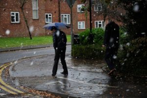
Take the umbrella
Widespread flooding is not anticipated, however, fast flowing water and flooding of low-lying areas, natural floodplains, and areas with poor drainage may be expected.
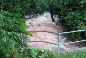
Creek capacity gets breached when rainfall is heavier tan normal.
Conservation Halton is asking all residents and children to keep a safe distance from all watercourses, Lake Ontario shoreline areas, and structures such as bridges, culverts, breakwalls, and dams. Elevated water levels, fast flowing water, and cold water temperatures combined with slippery conditions along stream banks and the potential for waves to overtop breakwalls continue to make these locations extremely dangerous. Please alert children in your care of these imminent dangers.
Conservation Halton will continue to monitor stream, lake, and weather conditions and will issue an update to this Watershed Conditions Statement – Flood Outlook & Lake Ontario Shoreline message as conditions warrant.
This Watershed Conditions Statement – Flood Outlook & Lake Ontario Shoreline will be in effect through Friday April 5, 2024.

Discover more from Burlington Gazette - Local News, Politics, Community
Subscribe to get the latest posts sent to your email.
