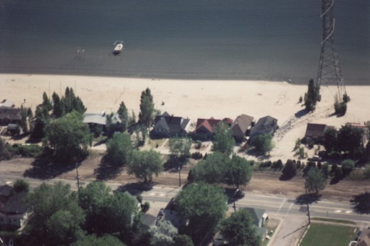
BURLINGTON, ON May 23, 2013 The beach to the west on the west side of the city, up tight against the canal that marks the border between Hamilton and Burlington has been a focus for Burlington for some time. A team of planners from Halton Region, the Conservation Authority and the city of Burlington delivered the report to a council committee meeting. This report follows a 1987 report and a 1994 report – all designed to come up with a Master Plan for Beachway Park.
A Master Plan for the area that was put together in 1987 that included mention of the park being “public open space” in its entirety.
A report with the impossible title of: Burlington Beach Regional Waterfront Park Comprehensive Background Report (hereafter known as CBR) pick up that theme and uses this one peg to hang one of its main points on – get rid of the houses in Beachway Park – to which the residents reply: – Not so fast . Some 30 families live down there and they want to see a community in the Beachway as something that makes the area safer.

Homes right on the lake’s edge with the rail line behind them and then Lakeshore Road. There were once several hundred homes in this part of the city – now there are 30 left.
The CBR is a background paper – it is not policy – yet but unless many of the points made in the report are properly refuted it has the potential to become policy – and should that happen we will all be the poorer.
Housing is just one of the issues set out in the CBR – the others are flooding in the area and what can be done to protect the sand dunes that are unique to the province. And those sand dunes are unique as the dunes in Prince Edward County where there is no housing but thousands of weekend visitors.
In this article we include significant parts of the 250 page plus document and set out those parts in bold italic.
The 1987 Master Plan for the beach provided a long-term vision that included a full-scale marina at Spencer Smith Park and the beach area as public open space in its entirety to accommodate a range of recreational amenities. One of the key objectives was the acquisition of all properties in the former cottage communities along Lakeshore Road including the leasehold lands (former Canadian National Railway lands) and private properties as they became available. Funding for acquisitions came from the Province through Conservation Halton, the Region and the City of Burlington. The acquisition of the properties was seen as a priority to:

The area to the left is known as the Beachway – Spencer Smith Park is shown on the right. Development of that part of Burlington’s waterfront is complete. The city now has to decide what it wants done with property that comes under Regional policy and Conservation Authority rules. Burlington manages the land and the parks within it.
The properties on the west side of Lakeshore Road are not threatened. To help with orientation Lakeshore Road is seen as running north/south with the lake on the east side.
Lakeshore Road cuts sharply towards Lake Ontario at the Maple Street intersection where the Joseph Brant Hospital and the Brant Museum are located. It is a very historic intersection for Burlington that once had a railway line running through it; was yards away from the location of the Brant Inn, once the hotspot for jazz musicians in Ontario.
Today that area is the western entrance to Spencer Smith Park and the eastern end of the Beachway Park.


