BURLINGTON, ON July 4, 2012 The Chair of our Regional government, Gary Carr, says: “Summer in Halton Region is a wonderful time and our waterfront and beaches are some of Halton residents’ favourite destinations.”
OK- you expect the chair to say something like that.

If the water on the north side of the boundary is not safe for swimming, why is the water on the south side safe for swimming. And is there a sign on the Beachway explaining the water isn't safe to the public that uses the Beachway Park?
Carr goes on: “To help residents stay healthy while being active, the Halton Region Health Department monitors the water quality at recreational beaches in Halton from the first week in June until the first week of September. Monitoring and samples are taken once a week at all public beaches.”
“The biggest influences on beach water quality are things we don’t have much control over such as: Environmental factors: the amount of rain water, wind & waves; warm water temperatures, large numbers of geese, seagulls, ducks and other water-birds.
What Carr fails to mention is that when we feed the geese they just poop more and that poop is the biggest part of what pollutes the water. Many people don’t know that.
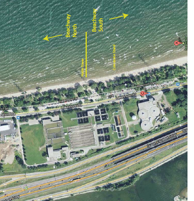
Every Wednesday the Region releases water quality reports for each of the parks in the Region. In Burlington they break the Beachway Park into North and South. It took a while to get the boundaries for North and South, which we post on the report we publish on water quality.
Now take a look at that map and tell me how one differentiates between the quality of the water on the South and the quality of the water on the North?
Better yet, how do people know where the boundary is? We get a lot of people coming to Our Burlington, but truth be told, everyone on those Beaches last weekend didn’t visit our web site.
So how do they know which part of the lake is safe and which part isn’t?
Wouldn’t it be a great idea if the Region posted a sign – and then an explanation on the factors that make the water on the northern part different than the water on the southern part?
And while they are at it – how about a dozen or so signs posted along the edge of the lake explaining why those far too fat geese should not be fed scraps of food. Use clear, straight to the point language – feed those geese and swim in the water their poop pollutes. That will get the message across.
Summer has just begun – still time to get those signs up.


