


 By Staff
May 22nd, 2019
BURLINGTON, ON
The following weather watch fron Conservation Halton has been issued to Shoreline Municipalities/Region, Emergency Services and School Boards at 12:05 pm.,

The Conservation Authority does not issue this level of warning very often
The latest information provided by the International Lake Ontario – St. Lawrence River Board (ILOSLRB) indicates that Lake Ontario levels will continue to rise over the next several weeks due to record high inflows from Lake Erie combined with reduced outflows from Lake Ontario which are required to limit downstream flooding within the lower St. Lawrence River.
The latest daily mean water level of 75.80 m (IGLD 1985 Datum) is approximately 75 cm above the historical average for this time of year but remains slightly below the highest levels observed in 2017. The latest Lake Ontario water level forecast suggests that there is a 50% chance that the current level could rise an additional 10 cm over the coming week and potentially reach or exceed peak levels recorded in 2017.
Levels are already at critical values in some areas, and there is also the potential for a greater rise depending on additional rainfall amounts.
Longer-term, Lake Ontario water levels are expected to peak and begin to decline within the next few weeks but will remain very high into the summer months.
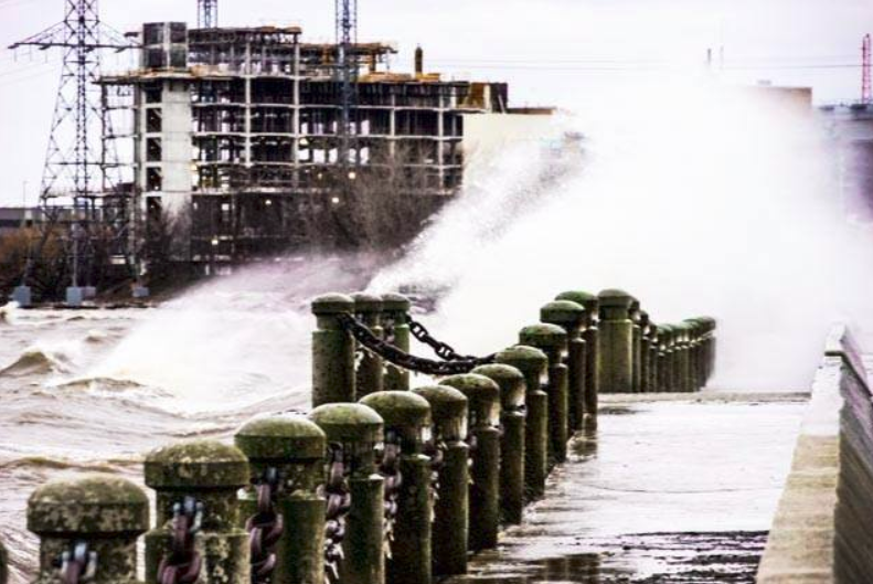
Structure in the background is the Joseph Brant Hospital that was under construction at the time.
All shoreline areas should be considered dangerous during this time. Localized flooding combined with the potential for waves to overtop break walls and other shoreline structures continue to make these locations extremely dangerous. Conservation Halton is asking all residents to exercise caution around Lake Ontario shoreline areas and to alert children in your care of these imminent dangers.
This Flood Watch – Lake Ontario Shoreline message will remain in effect until June 5th. Conservation Halton will continue to monitor Lake Ontario wind conditions and lake levels closely and will either terminate this message or issue further updates as necessary.

Discover more from Burlington Gazette - Local News, Politics, Community
Subscribe to get the latest posts sent to your email.
