 By Pepper Parr
January 9th, 2019
BURLINGTON, ON
Lakeshore Road east of Elizabeth could become a construction site for as much as a decade.
Bridgewater, the three structure complex that includes a hotel and two condo buildings, the tallest coming in at 22 floors, has been topped off.
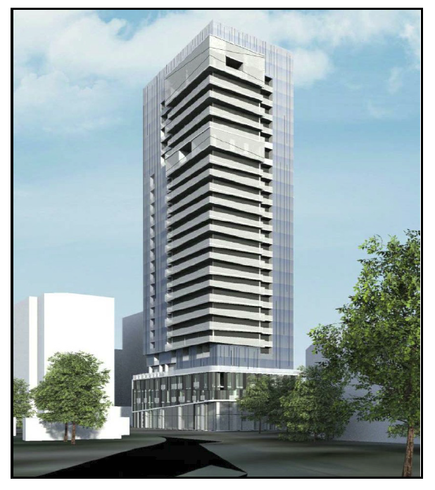
It took an Ontario Municipal Board hearing to get this development approved.
The ADI Development Group can now build the 24 storey Nautique and Carriage Gate has completed their application for a 29 story tower that will take up the south end of Pearl Street and half of the north side of Lakeshore between Pearl and Martha. The Nautique is on the other half.
The application is for a 29-storey mixed-use building with 280 residential units and 675 square metres of ground floor commercial retail space fronting on Lakeshore Road and Pearl Street that is to include:
Adaptive re-use of listed heritage buildings fronting on Pearl Street as Live/Work units
Five levels of underground parking (280 spaces) and at grade parking (11 spaces)
Car access from Lakeshore Road (that should be fun) with loading access from Pearl Street.
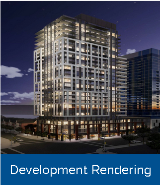
When completed this development will give Nick Carnacelli bragging rights to the tallest building in the city. The design is going to contrast significantly with the Adi development to the immediate east.
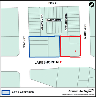
The Carriage Gate development will be on the left, with the two historically significant buildings on Pearl included. The Nautique, an Adi Group development, has been approved and is in the process of determining just where the water table levels out – they plan on five levels of parking on a very small site.
When development applications are deemed complete they then go out to the community for comment. The community meeting for this development (it has yet to be given a name) takes place at the Art Gallery on January 29th from 7 to 9 pm.
Some questions you might want to have in mind as you listen to the story the developer is there to tell: With 280 residential units and 280 underground parking spaces and 11 at grade how did the consultants arrive at traffic flow of approximately 81 new vehicle trips during the weekday AM peak hour and 97 new vehicle trips during the weekday PM peak hour.
There is also a wind study report that defies the facts on the ground. Take a walk along Lakeshore Road, on the north side and hold onto your hat; there is a bit of a wind tunnel as a result of the Bridgewater development on the south side. Don’t know how or where the consultants got the data in the report; walk along Lakeshore starting at Elizabeth – it is windy and with two more towers both above 25 storeys the wind tunnel effect will be just that much worse.
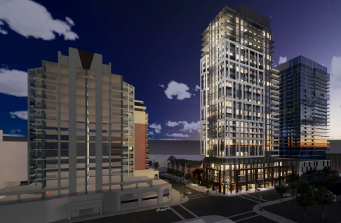
Nautique on the right, already approved via an OMB hearing, the Carriage Gate proposal in the middle. 360 Pearl is on the left. The historically designated property on the north side of the new development will be included.
The Gazette has been advised that the space between the Carriage Gate project and the Nautique is 22.2 metres at the ground levels. The Tall Building Guidelines approved by Council in 2017 required 25 metres between the upper level of high rise buildings – that space does not apply to the podium on which the tower actually rises.
The two 1880 era brick buildings that were once the Pearl Street Café are to be kept and re-purposed as live work sites. It would have been a hard sell to demolish the buildings; keeping them is probably the justification the developer uses to get an additional four storeys.
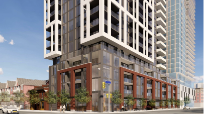
The Carriage Gate development proposal has a bold, almost muscular look to it.,
The design is a lot stronger than anything on Lakeshore Road now. There is bold use of marble that gives the building a bit of a muscular look. They are a strong contrast to the quiet beauty of the two historical buildings on Pearl that are being woven into the development.
The Heritage consultants brought in by the developer are of the opinion that:
• The building is not a candidate for full demolition.
• The building may be a candidate for facade retention.
• There may be opportunity for new infill development on the sides and to the rear of the existing structure. The side elevations appear to be blank walls, indicating that a continuous street wall may have been anticipated along Pearl Street at the time of the building’s construction.
• No new construction should obscure the heritage attributes located on the principal elevation of the structure.
• Any new construction should be setback from the principal elevation, allowing for the legibility of the original height of the existing building.
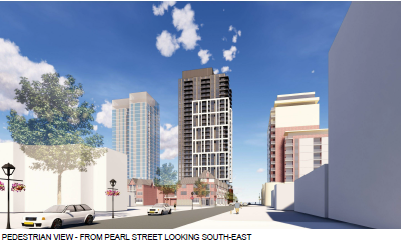
Nautique on the left will have 24 storeys, the Carriage Gate proposal in the middle is a 29 storey ask giving Nick Carnacelli bragging right to the tallest structure in the city – so far.
Originally constructed as a rental property for William Acland, a florist, in 1880. The building was sold in 1976 and underwent a series of interior renovations and the construction of a rear addition. A fire in 1989 damaged the interior of the building.
The consultants say the building “displays a high degree of craftsmanship in the brickwork and detailing. The property yields information that contributes to the understanding of the early development of Burlington.
The cultural heritage value of the property include:
The use of red and yellow brick materials;
The symmetrical appearance of the principal (west) elevation;
The wood detailing and elaborate brackets at the projecting ground floor bay windows, which also feature denticulate brick sills;
The second storey arched windows with intricate polychrome brick voussoirs;
The decorative brackets and projecting cornice with modillions;
The corbelled parapets at the gable end, with stone corbells;
The hipped roof; and
The three chimneys.

In this portrait Joseph Brant is seen wearing the gorget given to him by King George III. That gorget is the most important piece in the collection at the Joseph Brant Museum.
Putting the historical buildings in Burlington’s historical perspective –
At the end of the Revolutionary War, Captain Joseph Brant, a prominent Mohawk, was granted land in Halton County at the head of Lake Ontario, for his loyalty to the Crown. The lands commonly referred to as Brant’s Block, was patented to Joseph Brant in 1798. Joseph Brant lived on the north shore of Burlington Bay for 6 years prior to his death in 1807.
After his Brant’s death, James Gage purchased the southeastern corner of Brant’s Block, a 338.5 acre parcel of land. James Gage lived on a farm in Stoney Creek.
In 1810, James Gage surveyed his holdings, with the plan to establish the town site of Wellington Square. Wellington Square was not officially open to settlement until 1827-1837 when James Gage’s sons, Andrew and James, inherited the land. The Gage family were prosperous in Wellington Square.
James Gage built a saw mill, shingle factory, lath and stave mills in Wellington Square. His sons constructed a pier and wharf at the foot of Brant Street, and managed the Gage businesses.
By 1855, Gage sold much of his Wellington Square holdings, including land and businesses, to David Torrance and Company.
In 1874, the Village of Wellington Square and Port Nelson, the neighbouring village, amalgamated and were renamed the Village of Burlington. In 1877, the Village of Burlington was bounded by Caroline St. to the north, Torrance St. to the east, Water St. (now Lakeshore Blvd) to the south and Locust St. to the west. Some sources suggest that Martha, Maria, and James Streets were named after members of the Gage family and Torrance Street after David Torrance.
The Site is located within the historic boundaries of the Village of Burlington.
In 1915, Burlington was incorporated as a Town. In the 1950s Burlington annexed Port Nelson. Burlington was incorporated as a City in 1974.
Lakeshore Road, that was once known as Water Street, is going to be a much different part of town when block between Pearl and Martha is built out and occupied.
The challenge then will be – what does the city do with the “football” that piece of land bounded by Lakeshore Road and Old Lakeshore Road that has a number of historically significant properties and more than ten different property owners.
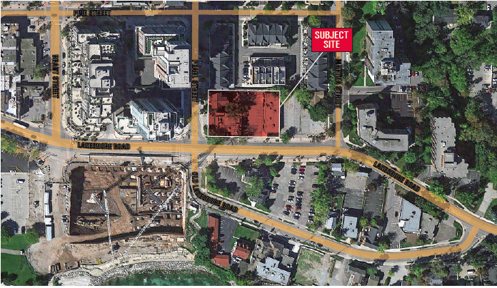
Former Toronto Mayor David Crombie once told former Burlington Mayor Rick Goldring that he needed to bring in some bright open minded people to meet and think about what could be done with the “football”. That was seven years ago.


Dreadful idea. Hopefully it will get nowhere near approval. Everyone knows that it is already a wind tunnel down there, and further walls blocking off the lake are just not acceptable. Council needs to use every means possible to stop another monstrosity from going up. Stephen White is bang on.
Developers can try all they might to deceive the public with their glitzy marketing campaigns and artist renderings of building silhouettes taken in isolation. The fact is that when you pile all of these high rise developments into a restricted land space what you get is a weird and ugly agglomeration of urban development that looks horribly disconnected, visually unattractive and congested. That is quickly becoming downtown Burlington’s legacy for future generations.
If the waterfront is our natural “jewel” then any development needs to reflect the visual beauty of the natural landscape. Constructing more hideous developments along the waterfront detracts from the natural surroundings and does nothing to promote the downtown core, the environment, or existing neighbourhoods.
Burlington downtown core has a unique history and culture. Developers like Carriage Gate might be well-advised to actually spent a little more time learning something about our City’s unique evolution. That way, they might then design something that blends artistically and aesthetically into the existing surroundings.
This Carriage Gate application appears to have been prepared prior to a) the OMB being replaced by the LPAT b) the October 22nd municipal election which caused a wholesale change of council c) the removal of City Manager, James Ridge d) the appointment of a new Director of Planning (Heather MacDonald) and e) a reset on development of Burlington’s new Official Plan (with the likely removal of Urban Intensification Centre & Anchor Mobility Hub designations).
You can’t fault Nick Carnicelli for asking, but given the change in the development environment in Burlington with all of the elements above, the adjoining 26-storey ADI Nautique application approval can no longer serve as a precedent. Whatever height permissions are allowed on this property within the current OP are what should be granted by the City. Nothing more. Period.
Interesting to say the least! What beautiful designer plans for what is closest to what Burlington is noted for “the waterfront”, or should I now say, “the barricaded waterfront”. We voted in a new Mayor, and all but one, a new council for reasons of these outrageous applications to come to a halt! Any acceptance of these strangling heights near our only breathable openness of our beautiful lake, to which majority of cities do not have the luxury of having, is a call to order by the City. As MMW (our Mayor) reiterated that, the City calls the shots! Now to set the standards going forward – and low they should be, for negotiating niceties that always allows for additions to. We have “true” mobility hub areas where these montrosities should go, not towering Lakeshore Road, traffic congestion to a halt (an area that has still not been sorted out to accommodate this density), and shading and wind tunnelling everywhere!! The Downtown Mobility Hub Study, Sept. 2017, nowhere had such heights mentioned in these locations! Now, is the time, once and for all going forward, that some sense needs to be incorporated into decision making. Brant and Lakeshore corner is another “pillar” on the planning table that has to be downsized to no more than 6-8 storeys! We don’t need “twins” on each side of the Brant Street window to the lake! This will be the test of whether the residents have any say in the shaping of their downtown. We all know that what is being brought forward by the developers are “to extremes”! They are very much aware of what they are doing, and will be happy to accept a few less storeys, and they will still be laughing all the way to the bank with surpluses to what should never be a consideration. Let’s not let this happen!