


 By Pepper Parr
October 6th, 2021
BURLINGTON, ON
Planner Alison Enns, Manager of Policy and Community, delivered a report on Floodplain and Spills Approach: Lower Hager and Lower Rambo Creeks. It was treated as a Receive and File document.
Alison Enns, Manager of Policy and Community,
It turned out to be a lot more than that – the information in the report has the potential to threaten some of the planned development along the path of Rambo Creek.
Enns purpose was to share how changes over time, new tools and approaches and the results of Phase 1 of the Flood Study, undertaken as part of the scoped re-examination of the Official Plan, have informed a change to how development in the Downtown is reviewed related to hazards south of the Hager/Rambo Diversion Channel.
Since the early 1980s the City has addressed development with respect to potential flood hazards in coordination with Conservation Halton. The Phase 1 Flood Study, finalized as part of the scoped re-examination of the Downtown, used new technology and information to identify hazards. That new information has informed a shift in responsibility from the City to regulation by Conservation Halton (CH) as of June 16, 2021.
Enns put up a slide showing the location of Hager, Rambo diversion channel.
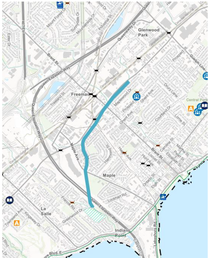
Blue line indicates the path of the Rambo Creek diversion channel.
The diversion channel was constructed in 1976 to divert water from residential areas around the downtown to prevent flooding. The main diversion channel captures water flow from upper Hager and the upper Rambo systems. It is approximately 2.7 kilometers long and outlets to Indian Creek, which in turn empties into Hamilton harbour and Burlington Bay.
In the early 1980s, the Halton Region Conservation Authority, in a memo dated September 7,1982, stated that the Conservation Authority doesn’t exercise jurisdiction over the Hager and Rambo Creek or the diversion channel. From that point forward drainage areas south of the diversion channel were considered to be under municipal jurisdiction and constituting part of the municipal storm drainage system.
The city addressed development with respect to the potential for flood hazards in coordination with the Conservation Authority, The regulatory policy was updated in 1999 and again in 2006, and in both of these documents that approach was confirmed.
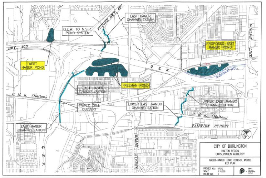
The storm water ponds that feed into the Rambo Creek diversion channel.
The various ponds, and their connection to the diversion channel are shown. Some context to help make the point about how we got here at the outset of the mobility hubs study…
There was an identified need for a scope of storm sub watershed assessment. Through that work and then subsequently through the work related to the downtown the scope re-examination, a final scope of that work was determined. In 2019 and carrying into 2020 the city retained Wood Consulting, in partnership with the Conservation Authority, to do a set of studies, which were called the flood hazard in storm water management assessment – commonly referred to as Phase One flood study. The purpose of that study was to define existing flood hazards for the areas where new development was anticipated, and also to develop a set of preliminary storm water management strategies. It also included reviewing drainage infrastructure capacity.
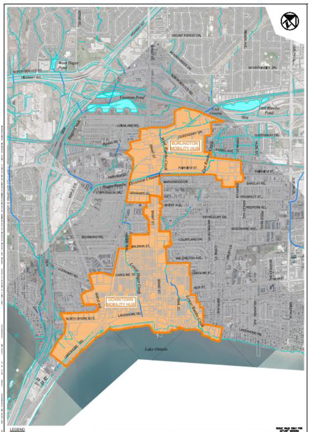
The map shows both the current but expected-to-be revised Urban Growth Centre and the boundary of the Burlington MTSA. It was while thinking through policy options that a concern about flooding became an issue. That concern led to two reports that highlighted a serious problem – the challenge now is how to deal with the flooding issue. The climate has changed – now what?
This is the extent of the phase one study area – note that it includes the downtown, and the Burlington GO.
The findings of the phase one study inform the development of policies and mapping that were endorsed by council in late 2020, and were incorporated in the approval of the new official plan by the Region. The Phase One study also identified that further technical work would be required. The recommendations of Phase One included identifying flooding hazards, providing recommendations for area infrastructure improvements, and included discussion of storm water management criteria but, really, the key elements of the Phase One work was to say that further technical work would be required to refine and confirm the flood vulnerable areas. That would be done through a phase two study which is currently underway using more detailed topographic survey data.
After the completion of the Phase One study, Conservation Halton, in accordance with the Conservation Authorities Act, determined they would exercise regulatory authority over lands in the vicinity of the lower Rambo Creek in downtown Burlington.
The city has incorporated this information in the Official Plan through the new official plan and Conservation Haltom has incorporated these new areas subject to flood risk in their mapping, which is available online.
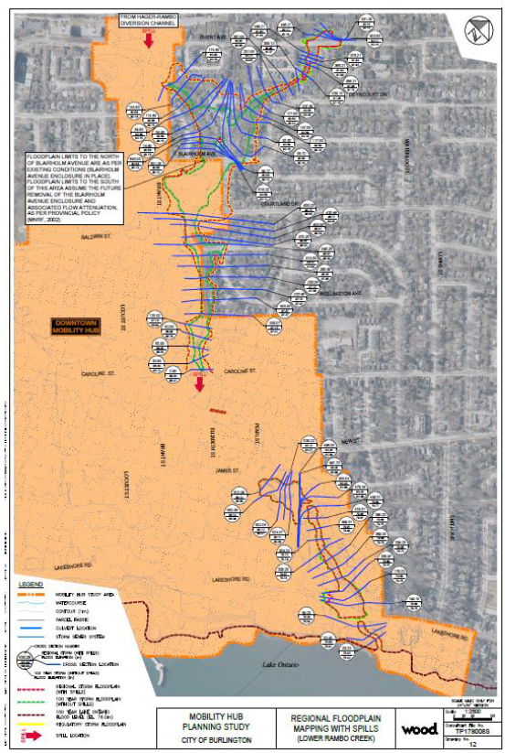
The scale of this map makes it very difficult to show the detail. We will try and get a map with better resolution and then present the map in sections. What is evident is that there are a lot of developments that are in what is thought to be a flood plain. Think of the damage done when the Tuck Creek broke its walls and flooded hundreds of homes. The city wants to take action now to put policies in place that will determine what can be built in possible flood prone areas.
June 16 2021 is the date after which Conservation applies the regulatory regulations to these areas.
Council saw the draft terms of reference in June. Staff is moving forward, refining the modeling from the Phase One study. That will determine if any further policy changes are required or any mapping changes. While Phase Two is not complete the Phase One study is considered best information; city and Conservation Authority staff will use that information to support the review of development applications.
With the Enns presentation completed – It was then on to Questions from Council. Mayor Meed Ward asked: when you look at the development proposals we have for the downtown many are identified as being in flood hazard areas. This may be, she continued, too early to answer this question but what does that mean, what do we know about what that means right now – does it mean no development there – does it mean, different kinds of development? What, what do you think it means – if you can answer that right now? With all the applications we have there appear to be a lot that are in a flood hazard area.
Enns had indicated that applicants will be required to interact with Conservation as part of the normal development approval process.
Councillor Nisan and the Mayor sit on the CH board and are aware that typically permits are not issued for developments that are within a hazard, that’s one of the protection areas. And in cases where the hazard can be mitigated, a permit with conditions might be issued.
What the Mayor was trying to get at is the potential that given the risk to health and given what we now know about flood hazards that permits will not be issued in some of these areas at all.
Through the permitting process, we would anticipate that depending on the issues that are present from a regular flood regulatory standpoint, this will influence design, and certain design outcomes as it relates to those projects, which is tied into the land use permissions. So we would not be proceeding from a planning standpoint to recommend approval of designs and final outcomes that conflict in any way, with the proper maintenance of the flood risk.
Any idea of when the phase two study might be complete and when we’ll be getting that information?
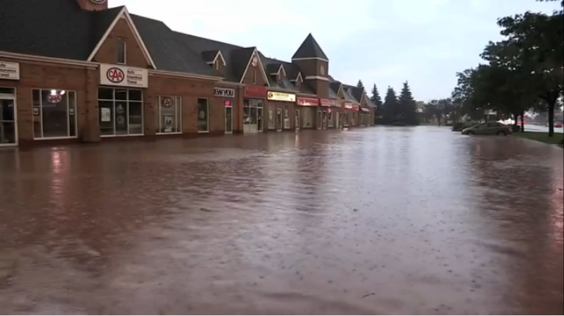
If there were basements in these buildings where records and archived documents were stored – they were a soggy pile of useless pieces of paper.
The target for completing phase two to line up with the MTSA work is, Q1 March of 2022. That work is happening very quickly and will help us answer some of these questions.
At that point Councillor Nisan was asked to move the item and it carried unanimously.
And with that – the fox was in the hen house. All those developments before the Planning department now face another hurdle that could determine if the application can proceed or if it should be modified to reflect the flood potential.
The developers would appeal to the Ontario Land Tribunal (OLT) – it would be very hard for an OLT Commissioner to find for a developer when looking at public safety issues.
This one should be really interesting going forward.

Discover more from Burlington Gazette - Local News, Politics, Community
Subscribe to get the latest posts sent to your email.
