


 By Staff
October 18th, 2021
BURLINGTON, ON
Burlington has embarked on a huge city building project.
When completed the city will have three distinct neighbourhoods; the eastern part of the city will have a new neighbourhood centered on the Aldershot GO station.
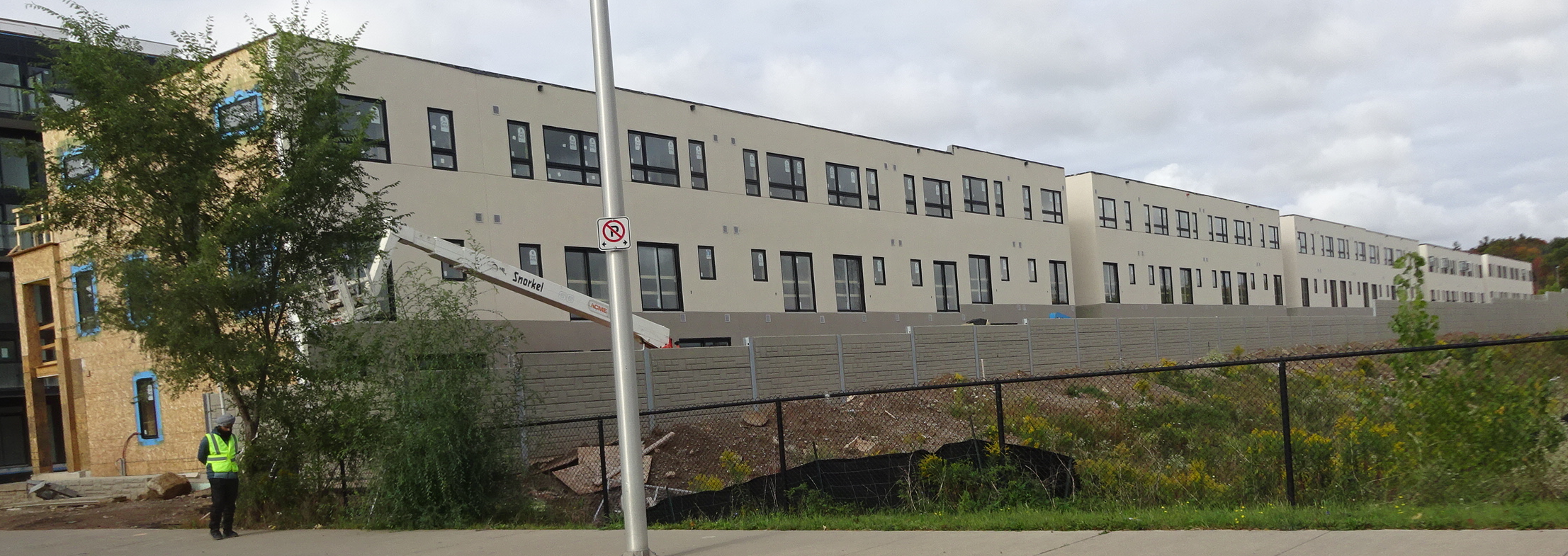
This is the western boundary of the Station West Development built by the ADI Group.
A significant part of the community building has already taken place in Aldershot. The Station West development by the Adi Group is well underway with three more towers to be built on the south west corner of the property that edges onto Masonry Road.
The other two new neighbourhoods will be centered on the Burlington and Appleby GO stations.
The city Planning Department is now working to get feedback from the people who will be impacted by these very significant changes.
A public meeting was held to explain what is planned. To get feedback from the public the Planners have devised a WORKBOOK that they say will take 30 to 45 minutes to complete.
Completing the WORKBOOK is voluntary and the information people provide is confidential (even to city staff).
The Planners recommend you complete the workbook on a laptop, tablet or PC to view the images in a larger format and keep a copy of the Preliminary Preferred Precinct Plan open in another tab or browser window to assist you in answering the questions and as a point of reference.
The link to the WORKBOOK is HERE. It is a little complicated. Just scroll through the pages, click on the images and then return to the page. There is enough instruction to get you through it.
The workbook is available in other languages. To request, e-mail getinvolved@burlington.ca. You may also use the “Select Language” translate button found on the project page to translate both the page and workbook.
An MTSA (Major Transit Service Area) is the area within 500 to 800-metres of a higher order transit station (these are the three GO stations) that are expected to be about a 10-minute walk from the GO station.
These are seen as the three most critical locations within the urban area expected to accommodate the majority of the City’s forecasted growth to 2031 and beyond.
Through the preparation of the new Official Plan, new policies were developed to guide development and change in the Downtown and Uptown (at Appleby Line and Upper Middle Road). The MTSAs are now the remaining priority locations for which detailed planning must be completed to establish the vision for growth, to guide development, investments in transit, infrastructure and public service facilities, including parks, and to support significant future population and employment growth.
To some this project may feel familiar. From 2017 to 2019 the City worked on developing area-specific plans (ASPs) for the three GO Station areas, then called the Mobility Hubs Study. The MTSA ASP project will build upon, and advance, the work done through the Mobility Hubs Study.
The objective of this project is to plan to accommodate new residents and jobs by setting a vision for three unique, complete communities that are centered around the City’s three GO Stations along the Lakeshore West rail line. These communities will be environmentally friendly, infrastructure-efficient, walkable, bikeable, and will support local and regional transit with a diverse mix of employment, housing, recreation, and shopping features.
What have we heard so far?
Engagement was a key element of the previous Mobility Hub Study work. From the feedback received through 2017 and 2018, a number of key themes emerged to provide guidance in planning for these areas:
Increase, Improve and Support…
Public spaces by supporting existing and new open spaces, parks and other community spaces that are safe, usable, inclusive and interactive, and incorporate public art, landscape features etc. to enhance placemaking.
Community amenities by encouraging an increased scale and mix of commercial/retail uses at grade, including grocery stores, coffee shops, community and recreational space etc.
Mobility by designing a well-connected, safe and accessible public realm with active animated streets and robust cycling and pedestrian networks, focused on direct connections to and from GO Stations.
Housing options by planning for a diverse range of different and affordable housing choices to cater to all ages and abilities.
Private Spaces by encouraging sustainable design and variety of architectural styles to create distinct buildings and enhance neighbourhood character, and by reinforcing midrise corridors.
Public engagement by providing residents with enough time to engage and increase resident engagement and clearly explaining the required growth targets for Burlington.
Parkland by planning for park and public spaces that consider the needs of the entire area including developing fair approaches to meet that objective.
Traffic congestion by supporting the public transportation network and investing in additional facilities for walking and cycling.
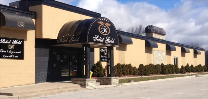
Solid Gold site as it exists today.
Building height and transition concerns by clearly explaining planning rationale for where height is being located, ensuring and explaining how height will be regulated, and by reducing losses of sunlight and privacy through appropriate building height transitions.
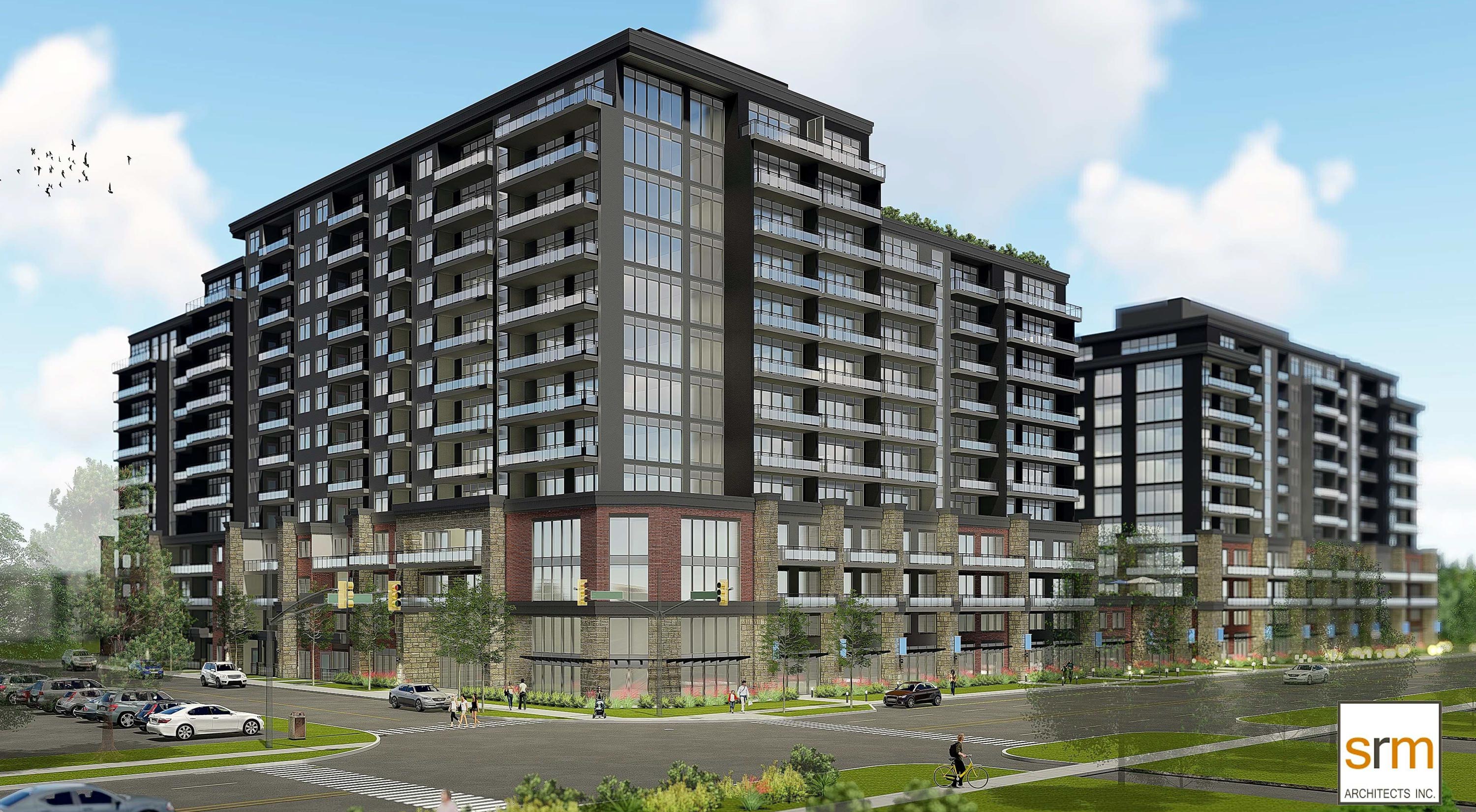
Speaking of height limitations – this rendering represents what the owners of Solid Gold want to build on a site that currently has a single story structure.
Protect…
Established residential neighbourhoods by ensuring built form, height and transition support and respect existing character, and providing clear policies for heritage protection.
The planners learned that:
Beyond the broad themes highlighted above, a number of key themes specific to the Aldershot GO MTSA also emerged, including the consideration of:
– opportunities for new bike paths, including through Aldershot Park;
– opportunities for amenities to support residents and employees;
– opportunities for complete streets, including Cooke Boulevard;
– ways to manage the impacts of increased traffic along Plains Road;
– opportunities to incorporate mid-rise development along Plains Road and Waterdown Road; and
– excluding the low-density residential properties located on Clearview Avenue and a portion of St. Matthew’s Avenue.
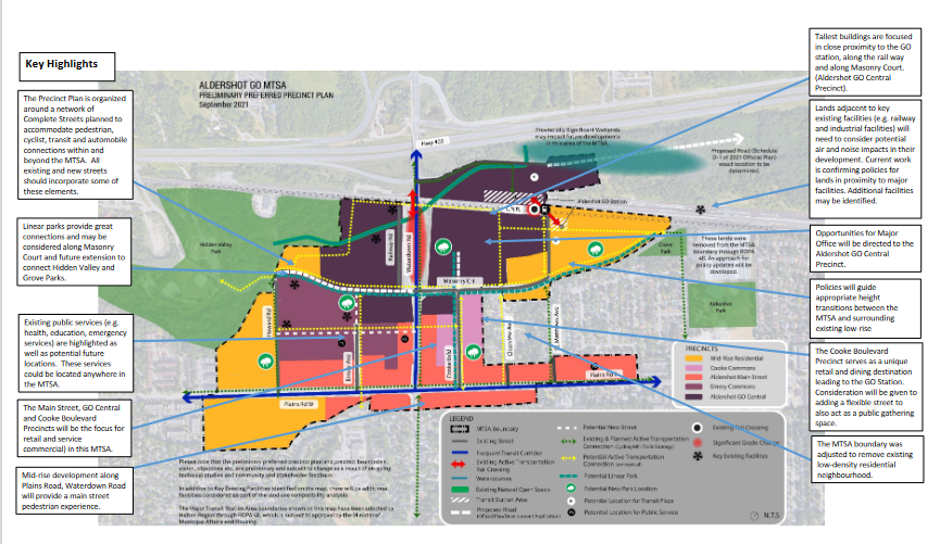
A little more detail on what might go where
Now the planners need your feedback. The input you provide may inform:
– Refinements to the vision (i.e. land uses, building heights, urban design considerations etc.);
– Precinct changes (i.e. policy directions, boundaries, built form directions, etc.);
– The preparation of the area-specific plans or the development of policy.
There are more specific details about all of the work that has informed the preliminary preferred precinct plan, including technical studies, can be found at getinvolvedburlington.ca/mtsa.

Discover more from Burlington Gazette - Local News, Politics, Community
Subscribe to get the latest posts sent to your email.

It is disturbing that none of these projects include consideration of education. Planning schools seems to be somebody else’s job.