


 By Staff
August 11th, 2016
BURLINGTON, ON
A combination of below-average precipitation this year with hot summer temperatures has resulted in water levels in local streams dropping well below normal.
As a result, Conservation Halton is escalating from a Level I to a Level II Low Water Condition for its watershed, based on criteria set out in the Ontario Low Water Response guidelines.
Conservation Halton’s data for the month of July indicates that like much of south central Ontario, the Halton watershed has received below-average precipitation and an unusually high number of very warm days. The watershed received an average of 43 mm of rain, which is only 54 per cent of the normal July average of 79 mm.
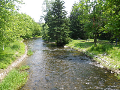
Bronte Creek isn’t looking quite this flush these days.
The three-month total for May to July was approximately 105 mm or 45 per cent of normal for this time of year, and there have been 24 days where temperatures surpassed 30°C during this period of time (compared to an average of six days for the preceding three years). Furthermore, current stream flow data indicates that many of our watercourses are in a Level II Low Water Condition, with monthly July flows averaging 35 per cent of the lowest average summer monthly flow.
A Level II Low Water Condition is the second level of an escalating scale of low water conditions. Under the Level II Low Water Condition, water users in the Conservation Halton watershed are strongly encouraged to voluntarily conserve water with the aim of reducing overall consumption by a further 10 per cent, to a new target total reduction of 20 per cent. Conservation Halton had previously issued a Level I Low Water Condition on July 8, 2016.

The Halton watershed is comprised of the Bronte, Grindstone, and Sixteen Mile Creek watersheds, which encompass portions of Puslinch, Hamilton, Halton Hills, Milton, Mississauga, Burlington and Oakville, as well as a number of smaller watersheds located in Burlington and Oakville.
The last time Conservation Halton declared a Level II Low Water Condition for its watershed was August 20, 2007. This Level II Low Water Condition was maintained until January 24, 2008 when it was reduced to Level I, then returned to normal conditions on February 6, 2008.
“The continued hot and dry weather conditions has resulted in the streams in the Halton watershed being lower than their typical levels for this time of the year and that is why we have moved to a Level II Low Water Condition,” said Conservation Halton Manager of Watershed Engineering Services, Janelle Weppler. “Given the situation, our team will maintain our increased level of monitoring and regular discussions with our Low Water Response Team. We encourage everyone to use water wisely.”
Major water users, such as golf courses, aggregate extractors, farm irrigators and others are asked to implement or continue their water conservation programs to reach the 20 per cent reduction target. Rural water users can lower the demand on the watercourses and aquifers by pumping water at a lower rate, storing it in ponds or by staggering their pumping times in conjunction with neighbours to lower peak demand. A 20 per cent voluntary reduction will help to provide water supplies for essential use and to sustain aquatic ecosystems.
Water users which rely on municipal sources are reminded to follow any water conservation measures as prescribed by Halton Region or their local municipality.
The Halton watershed is comprised of the Bronte, Grindstone, and Sixteen Mile Creek watersheds, which encompass portions of Puslinch, Hamilton, Halton Hills, Milton, Mississauga, Burlington and Oakville, as well as a number of smaller watersheds located in Burlington and Oakville.
• Normal – Normal Conditions are within normal limits.
• Level I – First indication of potential water supply problems, primarily a warning level – key focus is on voluntary conservation of water
• Level II – Indicates a potentially serious problem – conservation of water is extended to restrictions on non-essential uses
• Level III – Indicates a failure of the water supply to meet demand – key focus is on conservation, regulation and enforcement of non-essential uses.

Discover more from Burlington Gazette - Local News, Politics, Community
Subscribe to get the latest posts sent to your email.

We have problem with LOWVILLE GOLF COURSE using “ALL” the water and not allowing any water to flow in the stream comming out of the Golf course with result that the stream is “DRY” and all the fish ,Trout and aquatic life have DIED I have contacted Conservation Halton. Ministry of Natural resourses and all will not help
Don Dixon 3179 Britannia Rd
This article if very confusing. What is the Halton watershed? And which parts of Burlington are affected? The article say portions, of.
When they say “Portions of” they must mean whatever portions are agreeable to them Not the Enviromental effect. But it is OK for Golf courses to destroy streams
Interesting that Halton has a level 2 low water alert at the same time that Nestle, in Aberfoyle, is applying to obtain a 10 year extension to pump water from the underground aquifer. This will amount to 3.6 million Liters per day.
I can only assume that it’s OK for our neighbours in Wellington County to run potentially completely dry but in Halton we issue alerts.
When are we, as a society, going to wake up?
Certainly we cannot rely on corporations, such as Nestle, to lead the way, since their only concern is money. Will Nestle be around when we have to solve the problem of not enough water?