


 By Staff
October 18th, 2021
BURLINGTON, ON
We start with the city of Burlington within which there is the village of Aldershot, within which there is now Aldershot Corners. The Corners has five precincts.
There is a Preliminary Vision for the Aldershot GO Major Transit Station Area, and Aldershot Corners – a community within a village.
Located minutes from Hamilton at the western edge of Burlington, Aldershot Corners is a visitor’s first impression of Burlington when travelling east from Hamilton and Niagara on the Lakeshore West GO line.
The area is nestled within the Aldershot Village Business Improvement Area and focused at the corners of Plains Road, Waterdown Road and Cooke Boulevard. Part of the Treaty 3 lands, Indigenous People were stewards of the land for thousands of years before settlers arrived. Post-Colonially, this area was a major hub for brick manufacturing, and also has a rich agricultural past rooted in fruit production.
Aldershot Corners will continue to evolve as an urban area with a distinct sense of neighbourhood character, supported by a mix of residential, commercial and employment uses.
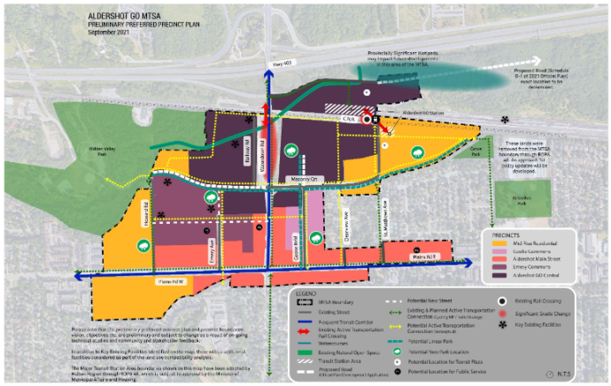
The colour coding sets out the precincts – detail elsewhere in this article explains what is planned for each of the precincts.
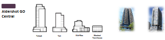
Taller buildings will be concentrated along the rail line and will decrease in height and intensity closer to Plains Road and the existing residential neighborhoods.
Aldershot Corners will be a vibrant, livable community with urban shopping and dining opportunities serving those living and working close by.
New multi-modal urban streets and active transportation facilities will better connect the existing community, providing enhanced mobility and improved access to the GO Station, leisure and recreation opportunities in urban parks and open spaces, as well the many other amenities Aldershot already offers.
The planners created a number of precincts, which are boundaries within which specified levels of development are permitted.
There are five within the Aldershot Corners part of the Aldershot part of the city.
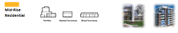 Mid Rise Residential.
Compact residential communities, with a variety of low-rise and mid-rise building forms up to 11 storeys closer to main streets. This Precinct will provide housing forms at a lower scale and intensity including family oriented and ground oriented housing to support the creation of a wide range of housing options, including affordable housing.
Opportunities for commercial activities at street level on strategic streets may be permitted. Policies will guide appropriate transitions from low rise residential development to more intensive mixed uses. Policies will guide appropriate transitions from the maximum height (11 storeys) to adjacent low-rise neighbourhood, which may include angular planes, setbacks and/or stepbacks.
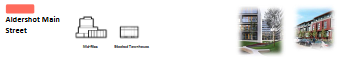 Aldershot Main Street
This Precinct will advance the Plains Road Village Vision and establish a unique community destination with a focus on a continuous retail frontage and main-street pedestrian experience along the frequent transit corridors (Waterdown Road and Plains Road E.) Policies will introduce a requirement for buildings to have a “lower building” design to create a pedestrian scaled environment at the street level. Policies will guide appropriate transition from the 11 storey maximum height to existing low-rise neighbourhoods, which may include angular planes, setbacks and/or stepbacks. Precinct lands that are adjacent to existing low rise neighbourhoods, will have a maximum height of 6 storeys. To ensure functional retail and commercial spaces are created, a wide range of approaches will be considered, including but not limited to establishing minimum floor height for the ground floor of buildings, and considering a minimum retail unit size. Opportunities for affordable housing will be considered in the Aldershot Main Precinct.
 Cooke Commons
Serves as a unique retail and dining destination creating a comfortable and vibrant pedestrian environment with active uses at the street level and increased emphasis on pedestrian and multi-modal movement. A flexible street is being considered to provide opportunity for a community gathering space and potential to close for special events.
Mixed-use buildings throughout the Precinct contribute towards the creation of lively, vibrant and people-oriented places. Along the west side of the street, heights range up to 19 storeys maximum adjacent to the GO Central Precinct and up to 11 storeys maximum generally along Cooke Boulevard. On the east side, there will be up to 11 storeys maximum generally along Cooke Boulevard which gradually steps down to 6 storeys with appropriate transitions, which may include angular planes, setbacks and/or stepbacks, to the adjacent low-rise residential neighbourhood. Policies will introduce a requirement for buildings to include a “lower building” design to create a pedestrian scaled environment at the street level. Direction to support the function of these areas to accommodate loading and services and support a wide range of retail use will be investigated and imbedded in policy.
Opportunities for affordable housing will be considered in the Cooke Commons Precinct.
 Emery Commons
This precinct will accommodate a concentration of residential, retail, employment and commercial uses.
Opportunity exists for a higher concentration of high density residential due to its proximity to an existing public park, a potential new major public park and the GO Central precinct. Mixed-use buildings, of varying heights to a maximum of 19 storeys, contribute towards the creation of lively, vibrant and people-oriented places. Opportunities for affordable housing will be considered in the Emery Commons Precinct.
 Aldershot GO Central
The preeminent destination for Major Office, affordable housing and urban format retail in this MTSA focusing the tallest buildings (maximum 30 stories) close to the GO station. Where Aldershot GO Central abuts Waterdown Road and Masonry Court policies will require pedestrian orientation development, including an emphasis enhanced public realm and enhanced spaces for waiting for transit. There is particular emphasis on the need to design a functional, safe and accessible transit plaza. Polices will ensure that the MTSA will accommodate a proportional mix of residential and employment opportunities and ensure that the Aldershot GO Central precinct will be planned to accommodate major office employment.
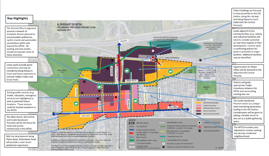
This map provides additional detail on what is planned for the different parts of what is being called Aldershot Corners.
What is it that is driving these changes?
KEY CHANGES – A number of things have changed since the Draft Precinct Plans were presented to the public and Burlington City Council in 2018. The following highlights the key changes that have been made or are being considered and the drivers for these changes.
Aldershot GO MTSA –
MTSA Designation and Boundary – Identified in Provincial Policy, the Regional Official Plan must first delineate and assign density targets to Major Transit Station Areas. Regional Official Plan Amendment (ROPA) 48 delineated the boundary for the Aldershot GO MTSA which identified the removal of existing parks (Hidden Valley Park, Grove Park and Aldershot Park), areas north of the rail line, and established neighbourhoods from the 2018 Aldershot GO Mobility Hub boundary.
Employment – Regional direction through Regional Official Plan Amendment 48 is to include employment within MTSAs. While Aldershot GO MTSA does not have an employment only precinct, Major Office employment type uses will be required in the Aldershot GO Precinct and it will be outlined through policy. Other employment types, such as retail, institutional and personal services is broadly encouraged throughout a number of the mixed-use precincts. Specific targets for Major Office will be established.

Comments made by the developer suggested there would be some retail – a Starbucks Coffee shop – but no mention of a supermarket – something the ward Councillor is anxious to see.
Retail – The Aldershot MTSA will provide two unique pedestrian focused retail experiences. The Aldershot Main Street Precinct provides ground floor retail with a main-street pedestrian experience. Policies will be considered for ground floor heights and minimum retail unit sizes to ensure functional spaces are provided. The Cooke Commons Precinct will serve as a unique retail and dining destination leading to the GO Station, with a focus on creating a comfortable and vibrant pedestrian environment with active uses at the street level and increased emphasis on pedestrian and multi-modal movement. In addition to those unique areas the opportunity to require, or in some cases encourage retail in every other precinct to support the day to day needs of existing and future residents.
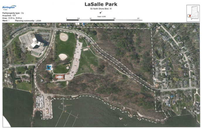
The only decent park is LaSalle Park; a 15 minute hike that will be stressed once all the residential development is completed. Great park with splash pads and a wading pool. Upgrades will be needed at some point.
Public Parks and Linear Parks – As noted in the Provincial Policy Statement publicly accessible built and natural settings including parklands are important ways to promote healthy, active communities. Potential locations for parks are identified with a green tree symbol. The City is considering other opportunities for wider corridors along streets to act as linear parks to provide valuable open space/park space and facilitate connections. A linear park along Masonry Court connecting Hidden Valley Park with Grove Park will connect residents, employees and visitors to existing green spaces. A new linear park extending along Cooke Boulevard from Plains Road East to new development north of Masonry Court will focus on providing opportunities to linger and to support safe, comfortable pedestrian access to the station. Enhanced connections, linear parks, new parks and other connections are required throughout the MTSA in order to facilitate safe and more direct pedestrian and active transportation routes to and from the GO station.
Public Service – As noted in the Provincial Policy Statement, public services such as healthcare, education, emergency and protective services, cultural activities and civic administration are necessary to sustain healthy, liveable and safe communities. Key precincts will provide community spaces, alongside new residential and retail development in key locations. In addition to that new focus in key precincts the “PS” icon remains in key locations where the consideration of the incorporation of public service facilities is critical. Public services will be located strategically throughout the MTSA and policies will be developed to ensure that these services are located strategically to support population and employment growth in coordination will be coordinated with future development.
Integrated Mobility – In 2019, the City launched its Integrated Mobility Plan (IMP). This plan establishes a vision of safe, accessible, sustainable, balanced and livable mobility for the City of Burlington. The goals of this plan represent a shift from a focus on cars to more choice in transportation options; with a target of 20+% of trips in urban areas to shift towards transportation choices other than personal vehicles. A Transportation Assessment is being undertaken to identify the local street network for each MTSA (see technical studies below) which will integrate the vision and goals of the city-wide IMP.
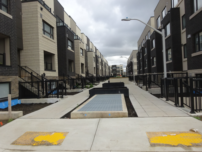
Newly built part of Station West – not much in the way of a complete street or parkland for that matter.
Complete Streets (formerly referred to as Green Streets in the 2018 Draft Precinct Plans) – The City’s new Official Plan identifies the need for complete streets strategy for all future street and road projects (new construction, reconstruction, resurfacing and rehabilitation). The OP also states that MTSA primary and secondary connectors (Plains Road East and Waterdown Road) shall be complete streets. With a long-term view, the City is proposing that all existing and proposed streets in the MTSA allow for inclusion of some complete street elements over time which could include space for pedestrians, cyclists, transit, and streetscaping in addition to travel lanes for cars.
Active Transportation – The City is committed to implementing active transportation corridors to improve connections and transportation choice. Planned active transportation corridors have been updated to be consistent with the 2021 Cycling Master Plan and the 2015 Community Trails Strategy. Active transportation corridors and connections proposed through consultation are also shown in the MTSA.
Climate Change & Sustainability – The City’s Climate Action Plan establishes a net carbon neutral goal by 2050 for community emissions. Work continues to identify ways for the City of Burlington to address the impacts of climate change and reduce greenhouse gas emissions. In addition to the transit and active transportation focus of the Aldershot GO MTSA consideration will be given to other ways future development of this MTSA could address climate change including encourage building energy efficiency, urban design policies to address heat and tree cover, and opportunities to consider district energy.
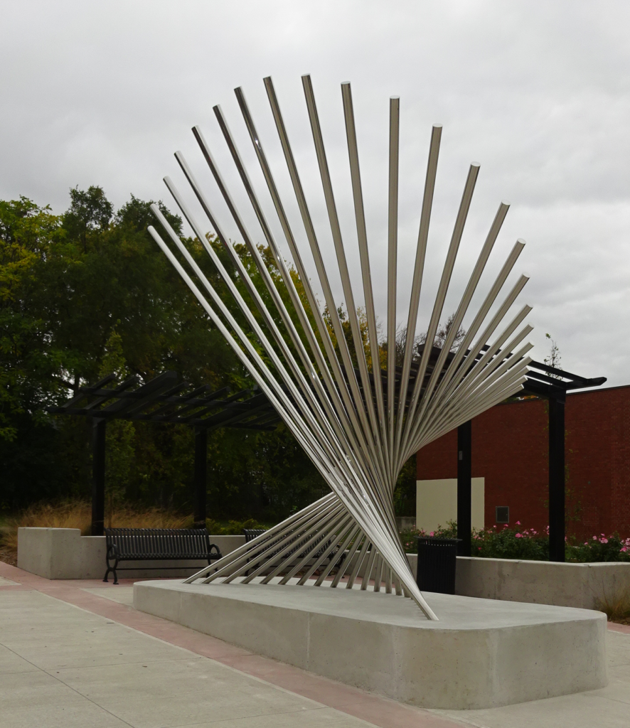
Public Art at the intersection of Waterdown and Plains Road
Frequent Transit Corridors – Plains Road E. and Waterdown Road are identified as Frequent Transit Corridors in the City’s new Official Plan. Pedestrian-oriented development is desired along these corridors to support the frequent transit service. Policies will be identified to encourage pedestrian-oriented development along these corridors including consideration of lower heights at street level, urban design and public realm requirements. Urban design and public realm can also improve the experience for those waiting for transit along these corridors.
Technical Studies Underway – The following technical studies are currently being undertaken and may result in the need for further revision of the Precincts.
- Land Use Compatibility – There are some major facilities in and around the Aldershot MTSA which may require separation from sensitive land uses like residences, day care centres and education and health facilities. Work is being completed to confirm the potential for land use compatibility issues within the MTSA and to develop a framework for technical assessments to be completed as part of future development proposals. This work may result in changes to the precincts or area specific policies in the Plan to guide land use change and minimize the potential for land use compatibility issues over time.
- Transportation Assessment – The current Aldershot GO MTSA shows the planned South Service Road and Masonry Court as shown in the new Official Plan as well as the proposed new streets included in the 2018 Mobility Hub. Traffic congestion has been regularly raised as a concern by the public and a transportation assessment is being undertaken to determine the potential impact of adding the new people and jobs to this area. In keeping with the vision of the IMP, it is anticipated that the Transportation Assessment results will focus on non-auto infrastructure and ways to shift people to other transportation choices. One of the key outcomes of the Transportation Assessment will be to confirm the need and location for any new local streets to support safe, efficient movement throughout the area.
- Inclusionary Zoning – As part of the City’s Housing Strategy, an assessment of options to implement Inclusionary Zoning (IZ) is being undertaken. IZ is a tool to integrate affordable housing into future development. IZ can only be applied to MTSAs identified as protected by the Province and Regional Official Plan Amendment 48 which requires the City to establish affordable housing targets for its Major Transit Station Areas. Should IZ be recommended for Aldershot GO, there will be a need for the appropriate guidance on how the tool will be applied.
- Environmental & Hazard Lands –Studies are underway to identify areas that may be prone to flooding. Completed Flood studies for Aldershot are currently being reviewed by Conservation Halton. Identified areas may need to be protected through policies within some of the Aldershot GO MTSA Precincts. A Provincially Significant Wetland has been identified to the northeast of the MTSA and any potential policy requirements are being assessed through updates to an Environmental Impact Study being undertaken as part of the background technical work.
Heights and Transition – The maximum heights in the Aldershot GO Precincts generally remain as presented in 2018. There have been some minor changes including changing lands just east of Cooke Boulevard from Emery/Cooke Commons Precinct with a maximum height of 19 storeys to a new Cooke Common Precinct with a maximum height of 11 storeys. Policies will be included to guide transition from the maximum height, typically closer to the main streets, to lower rise buildings adjacent to existing low-rise neighbourhoods.
There will be an in depth look at the Plans for the Burlington GO station area on October 19th and a similar event for the area around the Appleby GO station on October 26th. On November 4th there will be a review of the plans for all three MTSA’s.
All will be virtual events.
There is a WORKBOOK for those who want to pass their views and opinions along to the planners. The link to the WORKBOOK is HERE

Discover more from Burlington Gazette - Local News, Politics, Community
Subscribe to get the latest posts sent to your email.
