 By David Goodings By David Goodings
January 10th, 2018
BURLINGTON, ON
We live in an age of misinformation and partisan grandstanding. The latest examples—and there are many—have to do with raising the minimum wage in Ontario to $14.00 per hour at the beginning of this year and to $15.00 a year from now.
Articles on the minimum wage hike tend to be either pity-the-poor-workers or pity-the-small-businessperson. In the first category the authors stress fairness to workers and criticize businesses that can survive only by paying poverty wages to their employees. The second category emphasizes the likelihood of huge job losses and sympathizes with small businesses trying to survive in a highly competitive economy.
 How does one navigate through these troubled waters? Let’s start by trying to find answers to a few key questions. First, does the overall economy suffer? Secondly, who benefits and who loses? Thirdly, have the media been responsible in reporting the situation? How does one navigate through these troubled waters? Let’s start by trying to find answers to a few key questions. First, does the overall economy suffer? Secondly, who benefits and who loses? Thirdly, have the media been responsible in reporting the situation?
To answer the question about the overall economy and potential job losses it is necessary to look at employment data gathered by Statistics Canada or its counterpart in other countries. Fortunately, economists have not been idle in doing this. Numerous studies [1] [2] have found that increases in the minimum wage have had no measurable effect (after a few months) on the level of employment. This finding is not something that can be altered or fudged according to one’s political bias; employment data are as factual as the data on graduation rates from high schools.
Regarding who benefits and who loses, the minimum wage earners—more than a million in Ontario—have much to gain, though they will still be below the official poverty line, even working 40 hours a week. The economy also gains because people with low incomes spend any extra money right away, benefitting the local economy. The losers are small business owners who, for whatever reasons, are unable to raise their prices. (Tim Horton’s franchise holders are forbidden by their parent company, Restaurant Brands International, from raising prices.)
 Of course, if they find it necessary to raise their prices, so will their competitors, so they are not at a competitive disadvantage. Nevertheless, some small businesses may close or reduce the number of employees or reduce their hours and benefits. While that is regrettable, it may indicate that those businesses were operating unsuccessfully in a competitive market. The minimum wage increase may have the effect of eliminating some businesses that are not viable. Of course, if they find it necessary to raise their prices, so will their competitors, so they are not at a competitive disadvantage. Nevertheless, some small businesses may close or reduce the number of employees or reduce their hours and benefits. While that is regrettable, it may indicate that those businesses were operating unsuccessfully in a competitive market. The minimum wage increase may have the effect of eliminating some businesses that are not viable.
Finally, with regard to the media, it appears that many newspapers and other sources have tried to report both sides of this contentious issue, though I believe they have given more coverage to the plight of small businesses because the business community makes by far the most noise.
There is another aspect of the media response, however, that is troubling, namely, that news reports and headlines are sometimes alarming and lacking in context. An example is a recent research report from the Bank of Canada that predicted a slowdown in job growth amounting to 60,000 jobs across the country. This is a predicted loss of jobs being created in the future, not a loss of existing jobs. How was this reported? From the CBC: “Minimum wage hikes could cost Canada’s economy 60,000 jobs by 2019.” And from the front page of the Toronto Star: “Wage hike could cost 60,000 jobs, Bank of Canada says.”
These look like bad news stories, but what is missing is the fact that the Bank’s overall conclusion is positive, because “the 0.7 per cent increase in the level of aggregate real wages more than offsets the 0.3 per cent decrease in total hours worked.” An illuminating analysis of the Bank of Canada’s report has been given by Michal Rozworski of the Canadian Centre for Policy Alternatives. [3]
 The above example shows the importance of context. There is also, of course, the “spin” that editors put on news stories or opinion pieces. For some, Kathleen Wynne and the Ontario Liberal government are, finally, doing the right thing by helping the working poor in a meaningful way. For others they are simply opportunists with an election coming in five months’ time. The above example shows the importance of context. There is also, of course, the “spin” that editors put on news stories or opinion pieces. For some, Kathleen Wynne and the Ontario Liberal government are, finally, doing the right thing by helping the working poor in a meaningful way. For others they are simply opportunists with an election coming in five months’ time.
My opinion, for what it’s worth? One should weigh the benefits for over a million workers—less worry about paying the rent and feeding the kids, less reliance on food banks and unhealthy food, greater ability to pay for prescription drugs, afford transit, and see the dentist about a painful tooth—against the difficulty faced by a relatively small number of business people unable or unwilling to adapt through raising prices. It’s definitely time for a change.
 David Goodings David Goodings was born in Toronto and studied mathematics and physics at University of Toronto and Cambridge. He was a Professor of physics at McMaster University for thirty years and has been a resident of Burlington since 2001. He is an active member of Poverty Free Halton and Living Wage Halton. Married to Judy for 37 years which may be why his favourite piano piece is: Ain’t Misbehavin’ by Fats Waller.
Sources:
[1] Minimum wage hike won’t bring ‘doom and gloom’, economists say. Open letter by 40 Canadian economists endorses proposed provincial wage increase. Sara Mojtehedzadeh, Toronto Star, July 4, 2017.
[2] Wage Mythology. The minimum wage and the impact on jobs in Canada, 1983-2012, by Jordan Brennan and Jim Stanford. Report from the Canadian Centre for Policy Alternatives, October 2014
[3] Media get it wrong on Bank of Canada minimum wage study. Michal Rozworski of the Canadian Centre for Policy Alternatives in Behind the Numbers:
https://behindthenumbers.ca/2018/01/05/media-get-it-wrong-on-minimum-wage/#.Wk_CMOZvTts.facebook
Previous article.

 By Pepper Parr By Pepper Parr
January 10th, 2018
BURLINGTON, ON
Part eight of a multi-part editorial feature on the precincts and mobility hub being planned for the downtown core
 A development proposal for the Tall Precinct was taken to the city well before the thinking began on a new Official Plan. The Tall Residential Precinct is a new precinct created out of the existing Downtown Residential Medium/High Density Precinct. The Tall Residential Precinct reflects the existing built form in the precinct.
Draft Intention Statement:
The Tall Residential Precinct will primarily accommodate existing residential developments that are 12 storeys or higher and located at the periphery of the Downtown Mobility Hub. Limited development opportunities could exist within the precinct, which will be expected to enhance the street level experience for pedestrians through the incorporation of building podiums containing commercial and/or ground-oriented housing.
“While the framework for Tall Residential is generally intended to reflect the existing built form, some new policy directions are proposed to provide opportunities for limited infilling of existing mid-rise residential developments including the integration of new ground-oriented housing formats such as adding townhouse podiums at the base of existing buildings; introduce permissions for commercial activities at grade and require Transportation Demand Management (TDM) and mitigation measures within new development. The maximum building heights would continue to be established through the Zoning By-Law.”
 A lot of loose ends on the thinking done so far for this precinct. Not a lot of detail. And the height limitations on the west side of the city seem out of sync with what developers are proposing.
On the east side there is an application pending that exceeds the 12 storey limit that is being proposed.
Part 1 Evolution of precincts and hubs
Part 2 Brant Main Street
Part 3 – Parks and promenades
Part 4 – Bates precinct
Part 5 – Cannery precinct
Part 6 Old Lakeshore Road
Part 7 Mid Rise precinct
 By Staff By Staff
January 9th, 2018
BURLINGTON, ON
A reality check.
Report from city hall:
Snow Update: January 9, 2017 4:00pm
Snow clearing operations are complete.
Staff are continuing to address concerns.
Clean up continues to ensure catch basins are clear to reduce potential for flooding.
Photograph from Alton Village – at basically the same time.
The Alton resident did say that the city sent someone out to check on the quality of the snow clearance.

 By Pepper Parr By Pepper Parr
January 9th, 2018
BURLINGTON, ON
Does the Halton District School Board have a Plan B should the Ministry of Education tell them to do the Program Administrative Review (PAR) all over again because they didn’t get it quite right the first time?
If the Ministry of Education does decide there were flaws and errors in the way the PAR was done by the Halton Board and believes it has to be re-done – it isn’t likely to be done in the very near future. The Ministry has all but admitted that the process they created was flawed and they put a hold on any new PAR’s being done.
If the process does get revised it will take many months for the bureaucrats to figure out what was wrong and then make the changes. The process of involving public groups has already begun.
 Could there be a do-over of the PAR exercise. Pearson and Bateman parents hope so – Central high school parents are happy with the outcome. Assuming the Halton Board is told to re-do the PAR – that would mean going through the process all over again. The Ministry does not tell the Board to close a school. The elected school board are the people who make that decision.
What does the Halton Board do in the meantime?
 George Ward, a Pearson high school supporter thinks the Director of Education to have a Plan B. George Ward, a parent going door to door to convince parents to fight back said he has been told by the Director of Education, Stuart Miller that there was no Plan B – they were moving forward on the assumption that they would not be required to re-do the PAR. Good luck on that one Mr. Miller.
If there were a Plan B – what would it look like?
Right now the plan the HDSB has is to close two of the city’s seven high schools – Bateman and Pearson. Bateman will close its doors in June of 2020 and Pearson is to graduate a class in June of 2018 and then close the doors.
The Board has begun preliminary construction planning for Nelson high school which is to take in much of the existing Bateman program.
There are some very strong reasons for not closing either school.
Bateman offers a program that isn’t available anywhere else in the Region. It is unique and serves a demographic that needs special help and consideration. Many, perhaps most, people were just not aware of the program. The parents with disadvantaged and dearly loved children tended not to talk about program at their school.
 Despite the sign – the Bateman high school parents didn’t see their school at risk of being closed. They weren’t aware that their school was at risk despite the many warnings that were coming out of the school board administration.
Senior staff at the school board admit that communicating with the community is not one of their strong points.
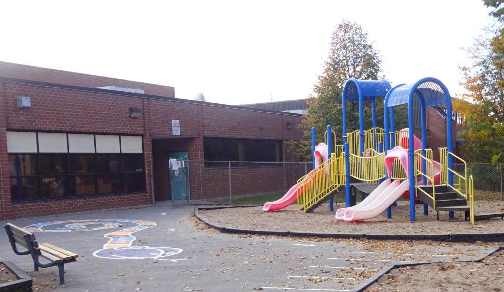 Playground at the nursery co-op attached to Lester B.Pearson high school. Pearson high school is a school that was “purpose built”; it was intended to be a small high school with a community component built into it. The Nursery, a best practices model, is supported financially by the city. Losing this school would be a terrible loss – to close it because the makeup of the feeder elementary schools were reconfigured is just poor management. The trustees have to bear the responsibility for that happening – they failed to give the Director the policy he needed to run things differently.
To be fair to Stuart Miller, the current Director of Education, has had to work with was on his plate – the big mistakes were made by his predecessors.
The trustees don’t bring all that much to the table in the way of communicating for their constituents. The members of the Halton District School Board have difficulty with seeing the bigger picture and giving the Director of Education policy that he can work within.
There is a bit of a silver lining – the trustees now have a new chair and vice chair. Andrea Grebenc of Burlington, the new chair and Tracy Ehl Harrison, the vice chair have an opportunity to change the quality of the decision making and to do the job trustees are elected to do.
Out of chaos and disappointment it is possible for creative leadership to come up with solutions that not only solve an existing problem but create a path for a new direction.
In February of 2017 the Board of Education staff brought the trustees up to date on where things were with the need for an administrative office that would meet current needs. The Singleton building on Guelph Line has to either be replaced or undergo a major upgrade. There are nowhere near enough meetings rooms – staff borrow an office that isn’t being used for a meeting.
 School board property – not enough space and a building that needs an upgrade. There is no lunch room. When staff decide to have a lunch they clear off a number of desks and lay the food out on the surface.
There is so much traffic in the building that the stairwell gets crowded and people have to turn sideways when passing another person.
The space is not adequately air conditioned.
The Ministry of Education will not fund a new administrative structure.
Within all this there is an opportunity for this Board of Education to come up with an idea that breaks new ground, meets both an administrative need, satisfies the demands and hope of a community that wants to keep its high school and retains a very valuable nursery operation.
How does the Board of Education do all that?
 They are just concepts – but they drawings suggest there is some thinking taking place. Sell the property on Guelph Line – the Board can do that because it is not a school. Build a new administrative office on the Lester B. Pearson site that would include the high school and the nursery and make all of it an integrated centre similar to the exceptionally popular and well run Alton complex.
Halton would have a complex of buildings that reflects the direction education is beginning to go in.
The complex in Alton combined a high school with a library and a state of the art recreation centre. Pay it a visit sometime – it is packed most evenings. The library is almost a mini community centre.
Halton ranks amongst the best with the grades the students get. It is a wealthy community that knows how to take care of those less fortunate.
 Director of Education with the newly elected chair of the Halton District School Board. But – what has the Board done in the last five years that is memorable? They opened Hayden high school which is the most popular in the city – all the students want to attend. It has far to many portables. Grouping several services in the one location works – the Board has an opportunity to do that again – redevelop the Lester B.Pearson site in a radical way.
Trite as the phrase can be – there is an opportunity for the trustees to think outside the box. Andrea Grebenc and Tracy Ehl Harrison, the Chair and the Vice chair, have an opportunity to create a school board that leads in the truest sense of that word.
Related news stories:
The Board of Education has been talking about a new administrative structure.
Salt with Pepper is the Gazette publishers’ opinion column
 By Pepper Parr By Pepper Parr
January 9th, 2017
BURLINGTON, ON
We now know just how much the city is prepared to share the role of handing out grants to the arts community.
Burlington is launching the Burlington Arts and Culture Fund (BACF), an annual program that provides grants to local artists, multicultural groups and arts and culture organizations to foster creativity and enrich how Burlington residents experience and engage with arts and culture.
An individual grant cannot be for more than $5000. The city has allocated a total of $50,000 annually to the project.
 Angela Paparizo was a recreational planner who became a cultural planner and is now the go to person on the cultural file as Manager, Arts and Culture. Trevor Copp one of the movers and shakers within the arts and cultural community was the artist who took the issue of local artists having to travel to Toronto to earn a living. Applications will be accepted until Feb. 28, 2018 and will fund projects from April 2018 to April 2019.
Successful grant applicants will be announced at the end of March 2018.
The maximum amount award amount is $5,000; the city has discretion with regard to the amount.
Once an agreement is signed 80 per cent of the grant will be paid out. The remaining 20 per cent will be paid when a Final Report is sent in.
Grants will be evaluated in part by a peer assessment jury for artistic merit and by city staff for program merit and strategic initiative, citywide and community impact and economic impact. A committee of local arts and cultural professionals and the Arts and Culture Council of Burlington (ACCOB), supported by city staff, have worked together to develop this arts and culture support program.
The good news here is that ACCOB gets to choose who will sit on the peer review committee.
Whatever the grant application – it has to comply with the Strategic Plan. One could win a big lunch bet on just how many arts types even know the city has a Strategic Plan never mind what it is supposed to do.
The BACF is using a point system to rank the applications. ACCOB will determine 30% of the point with the city determining the other 70%.
The administrative load is a little daunting. If one looked at the amount of paper work the city is going to have to work through and the time city staff spend on determining who gets a grant – it is probably higher than the grant itself. Welcome to the world of municipal government.
 When the arts community was getting its footing they met as a group and began a group think to come up with the direction they wanted to take with the city. There was some pretty solid thinking done. ACCOB has done a superb job of getting the city to the point where it now has an arms-length citizen run council that can work with the city to promote the arts.
ACCOB has run two very successful fund raising events; they brought Thomson highway to the Performing Arts Centre and they set up the Christmas trees that decorated the Family room during the festive season. Those two events put more than $5000 into the coffers.
Anyone interested in learning more about this opportunity and the application process is encouraged to join staff and arts and culture professionals for an information session on: Thursday, Jan. 25, 2017, 7 to 9 p.m., City Hall, 426 Brant St. Room 247
Culture is a program that in recent years has been overseen by the Director of Planning; prior to that it was overseen by Parks and Recreation where it was never a fit.
Mary Lou Tanner, formerly the Planning Director, now the Deputy City Manager has taken the cultural file with her. In a city media release Tanner said: “This grant will provide ongoing support and encourage the development of a variety of arts and cultural activities, adding vibrancy to the city. The benefits of a program like this have endless possibilities from intercultural understanding to friendship and removing cultural barriers to neighbourhood beautification.”
 The arts community – this grew into the Arts and Culture Council of Burlington Tim Park, President of the Board of Arts and Culture Council of Burlington believes: “This is a fantastic opportunity for local arts and cultural groups, individual artists and members of Burlington’s various cultural communities to present their talents to the residents of Burlington.
More information at Burlington.ca/artsandculturefund
By Pepper Parr
January 9th, 2018
BURLINGTON, ON
Part seven of a multi-part editorial feature on the precincts and mobility hub being planned for the downtown core
The Mid-Rise Residential Precinct is a new precinct created out of the existing Downtown Residential Medium/High Density Precinct in the Official Plan. The Mid-Rise Residential Precinct is intended to reflect the existing built form in the precinct.
Draft Intention Statement:
The Mid-Rise Residential Precinct will primarily accommodate existing residential developments consisting of 11 storeys or less. The precinct will serve as a transition from adjacent tall building precincts to established low-density residential areas. Limited development opportunities exist within the precinct, which will achieve a high degree of compatibility with the adjacent St. Luke’s and Emerald Neighbourhood Precinct as well as other established residential neighbourhood areas outside of the Downtown Mobility Hub.
 Mid Rise isn’t so much a geographical location – it is really a collection of locations that are going to have some development principles attached to them. “While the framework for Mid-Rise Residential is generally intended to reflect the existing built form, some new policy directions are proposed that will achieve a maximum building height of 11 storeys; provide opportunities for limited infilling of existing mid-rise residential developments including the integration of new ground-oriented housing formats such as adding townhouse podiums at the base of existing buildings; introduce permissions for commercial activities at grade and require Transportation Demand Management (TDM) and mitigation measures within new development.”
Those bones are pretty bare; nowhere near enough detail for such a sensitive part of the city. The Art Gallery will at some point undergo a major redevelopment which could be decades away.
Lakeshore Road in this part of the city needs room to breath – 11 storeys doesn’t seem to be a fit.
A considerable amount of property has been acquired by a developer
 The data shown to the right is not relevant however the property addresses are believed to still be in the hands of the developer. Councillor Meed Ward has some concerns with the proposals. She will be bringing forward a motion to add the North West corner of Burlington Avenue and Lakeshore Road to the Special Planning Area, and limit this area on both sides to 3 storeys
The bottom of Burlington Avenue and Lakeshore is in the precinct (pink area on the attached map). There are townhouses on the West side and single family homes on the East side (some divided into multi-dwelling units). The current zoning is 11 storeys. The proposed zoning would retain 11 storeys, with a Special Planning Area on the East side reduced to six storeys (thatched pink on the map with the arrow denotes Special Planning Area).
Meed Ward believes “both sides of this intersection should be treated the same, and with reduced height.
 There are a number of really fine homes once owned by prominent people who made the city into what it has become. There is a balance to this part of the city that need not be disturbed. “Burlington and Lakeshore is a gateway to the St. Luke’s Precinct of predominantly single family homes where we don’t want intensification. Allowing 11 storeys on one side of the street, and six on the other, would create pressure to extend growth up the street. Reducing development to three storeys on both sides would better complement and transition to the St. Luke’s Precinct, and is similar to the transition from Brant St to St. Luke’s where the height is three storeys along Locust – the new Bates Precinct.”
Part 1 Evolution of precincts and hubs
Part 2 Brant Main Street
Part 3 – Parks and promenades
Part 4 – Bates precinct
Part 5 – Cannery precinct
Part 6 Old Lakeshore Road
 By Staff By Staff
January 8th, 2018
BURLINGTON, ON
Canada’s major cities tend to understate revenue and spending, wait too long to release budgets, and confuse taxpayers with obscure figures in their financial reports, finds a new study from the C.D. Howe Institute.
The C.D. Howe Institute is an independent not-for-profit research institute whose mission is to raise living standards by fostering economically sound public policies. Widely considered to be Canada’s most influential think tank, the Institute is a trusted source of essential policy intelligence, distinguished by research that is nonpartisan, evidence-based and subject to definitive expert review.
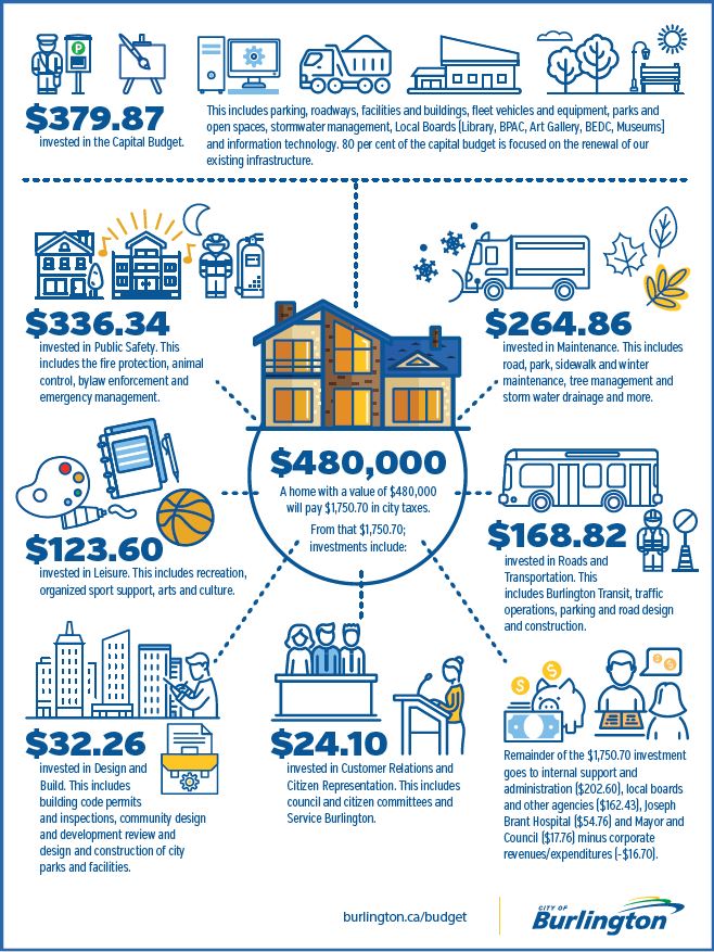 The Infograph does let you know where your dollars are going – is that enough? For 2017, each $100,000 of an urban residential assessment amounts to approximately $365 in property taxes for city services. In the 2017 edition of the Institute’s annual municipal fiscal accountability report card, titled “Fuzzy Finances: Grading the Financial Reports of Canada’s Municipalities,” the authors “found a dramatic divergence in the quality of financial reporting among municipalities”. “Sadly, this year’s report card highlights some marked declines in municipal fiscal accountability.”
While Burlington wasn’t one of the municipalities that was reported on the questions the authors of the report raised are still very relevant; especially for a city that has raised the tax rate by close to, sometimes above 4% each year for at least the past three years.
 Joan Ford, the city’s Director of Finance knows where every dollar comes from and where every dollar gets spent. The staff within the Finance department know their stuff; they have their fingers on every piece of information and when they are asked a question they have a direct answer – no “flim flam” from that department.
Where they err is on making the information available to the public and reconciling what they promise and what they deliver. Basically – the accountants aren’t as accountable as they need to be. The department has the capacity to better inform the public.
They aren’t told to do so by the City Manager who calls all the shots and they aren’t directed to do so by the elected city council.
 City manager James Ridge. There was a memorable occasion during the discussion of last year’s budget when James Ridge, the city manager, said that staffing needs just “bubble up” during Leadership Team budget discussions. At the time Ridge was asking for a $500,000 addition to the base budget. Councillor Meed Ward tried to get that pared back to $300,000 for the first year – she didn’t get the support she needed.
Jack Dennison, probably the best financial mind on council wasn’t aware that the $500,000 was being put into the base budget.
Much of that spending Ridge was asking for was to be on the Grow Bold initiative – and we know what we got for our money on that one.
 Burlington has always had a small group of citizens who get out to public meetings to review budgets, policy proposals and share ideas. In that regard we are fortunate. Unfortunately – the city no longer holds this kind of meeting – they did do a telephone call in program instead. The C D Howe Institute “urges municipalities to adopt accrual accounting in budgets – municipal governments should present their annual budgets on the same accounting basis as their year-end financial statements.
Present headline figures early and prominently in budgets and financial reports –municipalities need to display the key numbers in a more accessible manner. Burlington puts up some detailed Infographics that go part of the way.
Show gross, consolidated, municipality-wide spending – municipal budgets should show gross spending and revenue so that users of financial statements have a comprehensive overview of a government’s fiscal footprint.
Explain deviations from budget plans – municipalities should prominently display tables reconciling year-end results with budget promises.
Publish budgets and financial reports in a timely manner – municipalities should approve expenditures before the government spending happens.
Burlington misses this mark by a wide margin.
Municipalities are not allowed to operate at a loss. When Burlington’s Finance department reports on how they managed the collection and spending of taxes they have gotten into the habit of using the phrase a “positive or a negative variance” – they don’t like saying there was a surplus.
There is always a surplus – sometime a huge amount – it was once as high as $9 million. That surplus gets distributed into the numerous reserve funds the city has to draw on – that’s what prevent any kind of a loss in any one year. When the reserve funds are close to being depleted the city will include a top up amount in the next budget.
The favourite reserve fund is the Tax Stabilization account – it is a sort of the piggy bank that council can always go to when funds for something unexpected is needed.
“Clearer, more consistent figures and better accountability for hitting or missing budget targets would bring the financial management of municipalities better into line with their fiscal impact and their importance in Canadians’ lives,” the authors conclude.
In a CBC radio interview earlier this morning the authors of the report touched on citizen participation in the creation of the budget. A couple of public budget session ago Vanessa Warren, an advocate for more significant public involvement in the creation of the budget, asked why the meeting was being shown a budget but not being asked to be involved in the creation of that budget.
Burlington does a survey asking what people think of the budget – and always gets high marks. Councillor Dennison has not been known to question the validity of that survey.
City council passed a bylaw allowing the Finance department to send out interim tax bills for a budget that has yet to be approved.
By Pepper Parr
January 8th, 2018
BURLINGTON, ON
Part six of a multi-part editorial feature on the precincts and mobility hub being planned for the downtown core
The Old Lakeshore Road Precinct is an existing precinct that is being carried forward into the draft New Precinct Plan for the Downtown Mobility Hub.
 It has always been a controversial piece of land with much of it now in the hands of developers. It has always been a controversial piece of land with much of it now in the hands of developers.
Draft Intention Statement:
The Old Lakeshore Road Precinct will continue to serve as an area for mixed use mid-rise developments consisting primarily of residential uses, which are pedestrian-oriented and transit-supportive while achieving a high standard of design. Modest tall buildings may be accommodated where such developments achieve strategic public and city building objectives including the provision of public waterfront access and views to the Lake Ontario, among others.
The current policy framework remains unchanged through the proposed draft new Precinct Plan. An additional policy direction is being recommended through the Mobility Hubs Study process to allow for the future undertaking of a separate Area Specific Plan (ASP) process to review existing height and density maximums as well as the conditions for land development within the precinct based on the achievement of key city-building objectives.
The complexity of this area (Conservation Halton setback requirements, discussion of the closure of Old Lakeshore Road, land assembly) plus the City’s new tall building guidelines necessitate a future review of a narrower scale and geography. The Old Lakeshore Road ASP’s city-building objectives would include new pedestrian connections and park spaces along the waterfront; the creation of a new view corridor from Martha Street and Lakeshore Road to the Lake and a detailed study of the shoreline and its impacts on development in consultation with Conservation Halton.
 Old Lakeshore precinct continues to be “the jewel” that has yet to find a crown. This view is looking east with the Ascot Motel and Emma’s Back Porch on the right. Ward 2 Councillor Marianne Meed Ward made great use of the Save our Waterfront community group to advance her political interests – quite successfully. She focused on what could happen within the Old Lakeshore precinct and the construction of the pier and caught the public’s attention.
Meed Ward has been the only member of this city council who has consistently focused on the waterfront and worked tirelessly to save as much of it as possible.
 At one point during the 2010 election Meed Ward published a graphic showing what she saw as an option (a terrible option) the the piece of land sometimes referred to as the “football” – small piece of land between Lakeshore and Old Lakeshore Road. The Construction of the Bridgewater development which is on the western edge of the precinct radically changes what can be done with the land.
There was a time when it might have been possible to turn that part of the city into something that could benefit from some creative thinking – we appear to be losing that opportunity.
Part 1 Evolution of precincts and hubs
Part 2 Brant Main Street
Part 3 – Parks and promenades
Part 4 – Bates precinct
Part 5 – Cannery precinct
 By Pepper Parr By Pepper Parr
January 7th, 2018
BURLINGTON, ON
Budgeted at $11 million with much of the money coming from the federal government, some from the province and a more than decent amount from the Joseph Brant Museum Foundation the task of creating a much different museum site is about the begin.
One of the first tasks was the removal of the time capsule – which is now with the museum administration, perhaps on the desk of Barb Teatero, the Director of Burlington’s museums.
The brutally cold weather keeps crews off the site.
 In this portrait Joseph Brant is seen wearing the gorget given to him by King George III. That gorget is the most important piece in the collection at the Joseph Brant Museum. The current Joseph Brant Museum is a 1937 replica of the house Mohawk native Joseph Brant, Thayendanegea, built on a 1798 Crown land grant. A modern addition to the museum will be built into the grassy area under the current museum.
The expansion will add more than 12,000 square feet to its current size. This will allow the Joseph Brant Museum to become a cultural destination and a place to host national exhibitions and the collection of artifacts.
The current 5,000-square-foot museum will be expanded to provide barrier-free space for gallery displays, interactive programming, the storage of collections and community outreach.
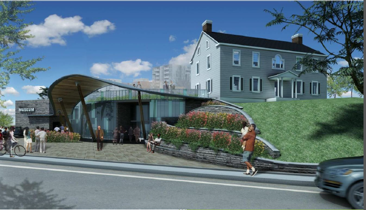 Architect’s rendering of what the transformed museum is expected to look like when completed. – Construction will take 18 months, depending on weather
– The total project amount is approved at about $11 million, which includes a contingency fund and allows for cost increases due to winter construction period.
Funding includes:
– $2.9 million from the City of Burlington
– $4.4 million from the Government of Canada
– $1.5 million from the Province of Ontario
– $2.5 million from the Joseph Brant Museum Foundation
By Pepper Parr
January 7th, 2018
BURLINGTON, ON
Part five of a multi-part editorial feature on the precincts and mobility hub being planned for the downtown core
The Cannery Precinct is a new precinct that is intended to accommodate the height peak at the southern end of the Downtown Mobility Hub and provide for future landmark buildings.
The Cannery Precinct was also created in response to public feedback about enhancing views to Lake Ontario from Brant Street and introduces a terraced built form and the opening up of the Brant and Lakeshore intersection to allow for pedestrian views and activities through the provision of new public space.

Draft Intention Statement:
The Cannery Precinct will be focused at and to the east of the Brant Street and Lakeshore Road intersection and establish this area as a major landmark location within the Downtown Mobility Hub. Developments within the precinct will establish a southern height peak for the Downtown Mobility Hub and be expected to achieve a high degree of architectural and urban design excellence and new public spaces befitting the significance of the area while ensuring that public view corridors to the Brant Street Pier and Lake Ontario are maintained and enhanced.
The key policy directions for the Cannery Precinct include the establishment of a maximum building height of 22 storeys provided that an enhanced public space is provided at the northeast corner of Brant Street and Lakeshore Road, significant cultural heritage resources are retained and public views to the Lake and Pier are preserved.
Policies will be established to require high quality architecture and urban design, building podiums and a minimum of two uses within buildings.
The planners have their views for this site; a small citizens group have well developed ideas that the planners have yet to fully embrace. Known as Plan B – there is a movement to reconfigure the way any re-development of the existing Waterfront Hotel.
 A group of residents have some well developed ideas an how the Waterfront Hotel site might be developed – they are finding the city planners a little hard of hearing. What is both instructive and disappointing is the way the resident view that citizens should be part of the planning process and the Planning department view that planners know best. This clashes with the city’s close to hypocritical statement that it fully engages its citizens.
Naming the precinct the Cannery pulls at some very deep historical roots – there was a time when a tomato processing plant existed at the bottom of Brant street and there was a real pier with real boats and ships tied up.
Before rail lines came into the city the lake was the route to getting product from the fields and the forests to markets.
Burlingtonians don’t, for the most part, know very much about their local history. The Brant Museum was never able to give that task the time, attention and resources needed.
Ward 2 Councillor Marianne Meed Ward has a big warm spot in her heart for the waterfront. Saving it was the issue that got her into office during the 2010 election.
She wants to reduce the cannery district at the north east corner of Lakeshore Road and Brant Street to 15 storeys.
This area (salmon on the attached map) is part of the new Cannery Precinct, with allowances to go to 22 storeys. The existing zoning Wellington Square Mixed Use Precinct, which allows height of 8-14 storeys.
 Delta Hotel on the right and the 22 storey Bridgewater condominium on the left. The Bridgewater is currently under construction on the South East side of Elizabeth & Lakeshore (circle on the right), with three buildings of 22, 8, and 7 storeys.
There is an existing 15 storey and 13 storey building at the North West corner of Brant/Lakeshore. Limiting height to 15 storeys would reflect roughly what is in the immediate vicinity of this parcel, and existing allowances.
When what is now known as the Bridgewater development was first brought to city council the site was described as the city’s legacy location and was at one point going to soar to 30 storeys – that was back in 1995 when the site was first assembled.
Part 1 Evolution of precincts and hubs
Part 2 Brant Main Street
Part 3 – Parks and promenades
Part 4 – Bates precinct
By Pepper Parr
January 6th, 2018
BURLINGTON, ON
It wasn’t me” he said.
“I’m just a tenant like the rest of the people in the plaza” said Bob Nadelko, owner of the No Frills on Brant street where Classic Towing has been pulling vehicles off the lot and using what appears to be a “flexible” pricing schedule for people who want to get their cars back.
The towing gets blamed on Nadelko because the brand name is up there on the bright yellow building – people just assume that I am the guy calling in the tow trucks explains Nadelko tells of the occasion when he was on vacation in Portugal and got a call from one of his regular No Frills customers asking why he towed her car.
“I wasn’t me” explains Nadelko.
 It isn’t a public parking lot – and it isn’t the No Frills parking lot either but it is roaming territory for the Classic tow trucks – Up to $350 to get your car back. In order to have cars towed from private property you have to have what Nadelko calls “a signature” or signing rights which is a relationship with city hall.
Earlier this week the Gazette reported on five of a group of six woman enjoying a holiday drink at Joe Dogs had their cars towed. They felt that it was latish in the evening, the parking lot was close to empty – they saw no reason why they shouldn’t park their cars.
Even though it is private property “people just seem to feel they can park their cars because it is convenient” – the flak falls on the No Frills brand.
Nadelko, who has owned the franchise since 1999, has nothing but great words for the community he serves. These are wonderful people. I have hired young people who first came to this store with their Mother’s when they were babies.
Nadelko, who lives in Vineland, does not own the property and does not have the authority to have a vehicle towed off the parking lot.
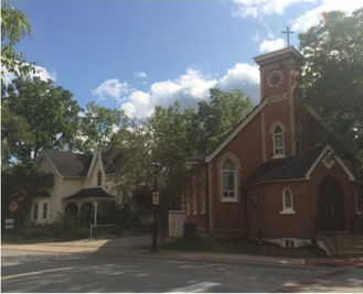
 Lisa Lunski, Wellington United Church community coordinator. keeping an eye on the kitchen crew that helps prepare ther community dinner. The people from Wellington Square United Church do their food shop for the community dinner they serve regularly.
No Frills is a franchise unit of the Loblaws organization. Nadelko said that he can’t make any comment on the price fixing mess Loblaws is embroiled in but he loves the idea of people signing up for one of the gift cards that are going to be handed out and have them passed along to the Wellington United Church people to help with the sizeable food bill for the community dinner they serve.
Related news stories:
Complaints from those who had their cars towed
Getting one of those Loblaws gift cards
 By Ray Rivers By Ray Rivers
January 6th, 2018
BURLINGTON, ON
2018 is going to be a year of surprises.
On the international front, America’s Supreme Leader will visit North Korea. After an inspection of Kim’s ‘goose-stepping’ million-man army, he will dine with the North Korean leader over a meal of Kimchi and Korean-style barbecued Rottweiler – a meal, as Kim will say, befits the lead running dogs of communism and capitalism.
 Who has the biggest red button? Following the state dinner Trump and Kim will discuss plans for nuclear cooperation and reunification of the Koreas, in addition to comparing the size of their respective nuclear buttons. Trump will return home a self-described hero for bringing peace to the Korean Peninsula, though he will have to be admitted to hospital almost immediately for medical attention related to an acute case of intestinal parasites.
But his successful visit will be instrumental in allowing the Republicans to win the mid-term elections and continue their best efforts at eliminating taxes on the wealthy and ending publicly supported health care. Most pundits will attribute the GOP victory to the campaign promise of tearing up NAFTA as the best way to make America great again – keeping American jobs out of Canada and Mexico and bringing them back to the USA and China.
On another front President Trump will decide to completely end all military activity in Afghanistan. The US diplomatic break with Pakistan and a dramatic upturn in al Qaeda, ISIS and Taliban military victories, coupled to general public disillusionment with America’s longest war, will be cited as the primary reasons for the US withdrawing from this region. Trump will tweet that his decision is consistent with history – citing the Russians and British who also left the country with their tails between their legs.
 Between the two of them, Horwath and Brown, they form the next government. Ontario voters will surprise even themselves by electing an NDP minority government which will be supported by the Green Party, having elected its first Ontario MPP candidate ever. Patrick Brown will place a close second to NDP leader Horwath. Still his party’s rank and file will demand his resignation blaming him for running a campaign borrowed almost entirely from the Liberals. Brown will step down, making way for ‘heir apparent’ Caroline Mulroney to lead the provincial party. Karl Heinz Schreiber, having just been released from a German prison, will offer to help her with fund raising, much as he tried to help her father.
The Liberals will attribute their election loss to their decision to increase the minimum wage. The NDP which had also supported the wage increase will attribute their own victory to the promise to nationalize all Ontario franchises of Tim Hortons in the public interest, and to unionize its workers under CUPE, which also represents the garbage workers. US based ‘Restaurant Brands’ which had owned Tims, as well as Burger King and Popeye, will plead unsuccessfully for a ruling under the defunct NAFTA. “Tim Hortons is the hole in the donut that nourishes the lives of all Ontarians” Horwath will be quoted as saying.
 Male actors and directors of theatre and film in Ontario have formed an association to support them against what they call the mischievous accusations of sexual misconduct running amok throughout the industry. Called the “# Fork You Too” these actors will announce their refusal to engage in any intimate scenes with female actors and demand that all female roles now be played by men in drag, as they were in Shakespeare’s day. This will cause great consternation in the entertainment industry, particularly among those engaged in the pornography sector. Male actors and directors of theatre and film in Ontario have formed an association to support them against what they call the mischievous accusations of sexual misconduct running amok throughout the industry. Called the “# Fork You Too” these actors will announce their refusal to engage in any intimate scenes with female actors and demand that all female roles now be played by men in drag, as they were in Shakespeare’s day. This will cause great consternation in the entertainment industry, particularly among those engaged in the pornography sector.
Most of Canada experienced its coldest winter in decades in early 2018. In response the federal Minister of the Environment has announced the decision of the government to join the US and withdraw from the Paris Climate Change agreement. Despite accusations by David Suzuki that the government is confusing weather for climate, the PM will defend this position, at the opening of a new tar-sands plant in Alberta, noting, “It is clear that our efforts to mitigate global warming have succeeded in bringing us back into the cold,”
So there you have it folks. Recall that last year I just about nailed it… well the Keystone XL pipeline prediction anyway. And recall that it was in this column where you read it first, in 2016 – I predicted Donald Trump would be elected president.
Happy New Year. May we all live in interesting times, even without the surprises predicted above.
 Ray Rivers writes weekly on both federal and provincial politics, applying his more than 25 years as a federal bureaucrat to his thinking. Rivers was a candidate for provincial office in Burlington in 1995. He was the founder of the Burlington citizen committee on sustainability at a time when climate warming was a hotly debated subject. Tweet @rayzrivers Ray Rivers writes weekly on both federal and provincial politics, applying his more than 25 years as a federal bureaucrat to his thinking. Rivers was a candidate for provincial office in Burlington in 1995. He was the founder of the Burlington citizen committee on sustainability at a time when climate warming was a hotly debated subject. Tweet @rayzrivers
Background links:
Dog Meat – More Dog Meat – Other Predictions –
Tims – Tim Hortons – Rivers 2017 Predictions –
By Pepper Parr
January 6th, 2018
BURLINGTON, ON
Part four of a multi-part editorial feature on the precincts and mobility hub being planned for the downtown core
The Bates Precinct is a new precinct which formally recognizes the policy direction in the current Official Plan to retain and improve the existing character of the low-rise areas located on the west side of Brant Street, between Baldwin Street and Caroline Street and the west side of Locust Street between Caroline Street and Elgin Street.
 The Bates Precinct also responds to public feedback, which identified a strong desire to protect existing heritage character in the downtown. The Bates Precinct also responds to public feedback, which identified a strong desire to protect existing heritage character in the downtown.
Draft Intention Statement:
The Bates Precinct recognizes and preserves the concentrated historic character along sections of Locust and Brant Streets including buildings and streetscapes. The precinct acknowledges that limited opportunities for development may exist and will respect and respond to the existing historic character of buildings and their adaptive re-use over time, through the use of building forms and materials currently existing within the precinct as well as by maintaining the existing parcel fabric.
The proposed Bates Precinct includes a Special Policy Area located at the northwest corner of Elgin Street and Locust Street that recognizes the node created by the Burlington Performing Arts Centre, City Hall, the approved Saxony development and the future extension of the Elgin Promenade.
 The Saxony was approved for four storeys – the developer as returned to the city asking for permission to add an additional two storeys to the development. No mention is made of what height restrictions might be for that Special Policy Area. If the city is every going to do anything with the existing city hall – that location becomes critical.
 The Bates Precinct includes key policy directions intended to retain the last remaining historical streetscapes, buildings and building fabric as well as to establish a maximum building height of 3 storeys to ensure the compatibility of new development within the precinct and with the adjacent St. Luke’s Neighbourhood Precinct. The Bates Precinct includes key policy directions intended to retain the last remaining historical streetscapes, buildings and building fabric as well as to establish a maximum building height of 3 storeys to ensure the compatibility of new development within the precinct and with the adjacent St. Luke’s Neighbourhood Precinct.
What little there is left of that older downtown Burlington everyone wants to see retained is in this part of the city.
Related articles:
Part 1
Part 2
 Map showing the location of all the precincts in the downtown
By Staff
January 5th, 2018
BURLINGTON, ON
It was a very relieved Regional Police Chief who sent a letter electronically to everyone in the Region – thanking them for the help given to avert the death of a senior who was out in the freezing weather without winter clothing.
 Margaret McCormick found in a wooded area some distance from her senior’s residence. Margaret McCormick was reported missing at 2:30 yesterday. The alarm went out and the frantic effort to find the woman before she froze to death began.
The police knew what they were up against and they pushed every button they had available to them. Evening was approaching – the police knew there was no time to spare. Things tightened up in the communications section where everyone was an edge – waiting for that critical telephone call. It came – well let the Chief thank everyone.
Chief Tanner, in his open letter said: “As experience has shown us, whenever someone vulnerable goes missing in the community, every minute counts.
“On the afternoon of January 4, a 78-year-old woman wandered away from her senior’s residence in Burlington. Without a winter coat, physically frail, unfamiliar with the area, and with temperatures plummeting to record lows, it was a race against time to locate this resident and bring her home safely.
“Halton Regional Police Service put out an immediate call to action, and the community responded in an emphatic way:
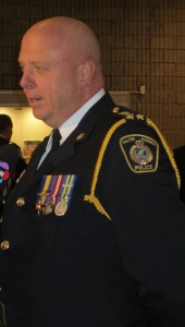 Regional Police Chief Stephen Tanner “Our local and regional media partners worked swiftly to assist us in circulating key details to the public;
“The public leveraged their full social media potential to extend the reach of the missing person alert; and
“Local first responder partners (including Burlington Fire and Halton EMS) coordinated resources quickly and seamlessly in extremely challenging and exigent conditions.
“Four hours after she first went missing, acting on a tip from CN Railway personnel, the elderly woman was located in a wooded area, conscious, but suffering from cold-related injuries due to exposure to the harsh elements. She is currently recovering in hospital.
“We are strongest when we work together. Last night’s incredible outcome would not have been possible without the support and contributions of our entire community — the public at large, members of the media, and all first responder agencies.
“I thank you, on behalf of the entire Service, for your continued support of our efforts to preserve and enhance community safety and well-being in Halton Region. We could not do what we do without you.
“Together, we truly are one team.”

By Pepper Parr
January 5th, 2018
BURLINGTON, ON
Part three of a multi-part editorial feature on the precincts and mobility hub being planned for the downtown core
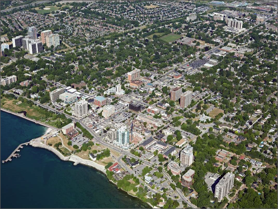
Parks and a big part of the way people experience Burlington. Stretched out along the edge of Lake Ontario the city was able to keep some of the property public – not all of it – the bit of land between Market and St. Paul got away on city hall but that is another story.
Spencer Smith Park is the largest focal point the city has – the Beachway Park to the west of that will result in a very significant piece of parkland space along the edge of the lake – is a
In drafting a new Official Plan the city decided to revise the precincts the downtown core is divided into and revise some of the boundaries and add new precincts. There are now 13 of them.
 The Parks and Promenades Precinct is an updated precinct that builds upon the existing Waterfront West/Public Lands Precinct and identifies current and future parks and promenades in the Downtown Mobility Hub as well as the connections between them. The Parks and Promenades Precinct is an updated precinct that builds upon the existing Waterfront West/Public Lands Precinct and identifies current and future parks and promenades in the Downtown Mobility Hub as well as the connections between them.
Each precinct has a draft intention statement attached to it. For Parks and Promenades it is:
Draft Intention Statement:
The Parks and Promenades Precinct will identify current and future parks and promenades within the Downtown Mobility Hub, which will serve the residents and employees of the Downtown Mobility Hub and also function as key destinations for city-wide and regional events and activities. In addition, the precinct will recognize the need to maintain and enhance public access to the waterfront and identify key linkages to ensure pedestrian and cycling access within the Downtown Mobility Hub and adjacent areas.
 A site laden with history and now the prime gathering place in the city. The key policy directions for the Parks and Promenades Precinct include establishing new promenades including from St. Luke’s Anglican Church south to Lakeshore Road, the multi-modal extension of the Elgin Promenade from Brant Street to Brock Avenue and a pedestrian path along the west bank of the Rambo Creek between Caroline Street and John Street. In addition, this precinct recognizes the Burlington War Memorial (Cenotaph) as a park and identifies a future urban park in the general vicinity of Brant Street and Birch Avenue, which would include a new east-west pedestrian and cycling connection between Birch Avenue and Emerald Crescent.
 A series of short promenades are being built that will let people travel through the downtown core without having to be on public streets. When fully completed people will be able to cycle right across the city. With a big push on cycling the city has taken to the idea of promenades that stretch through the downtown core.
The planners are proposing a futurre park for what is now the location of No Frills supermarket – with the additional population that is going to live in all these condominiums – even if they are only six to eight storeys high – where will people buy their food?
Related editorial:
Where will the millennial’s live.
The park opportunity that got away on the city.
Part 1
Part 2
Map with all the downtown precincts.
By Staff
January 5th, 2018
BURLINGTON, ON
It was never going to be an easy piece of municipal legislation to get passed by Council.
It is a misunderstood document that forms the foundation of how the city is going to grow. Many think that everything in the Official Plan can never be changed – it isn’t that kind of a document.
The Official Plan evolves – it takes wisdom and experience to ensure that the Plan meets the needs of the city.
The public response to the current draft of the Official Plan has been what should have been expected.
 Ward 2 Councillor Marianne Meed Ward intends to put a motion before city council that would have the approving of a new Official Plan deferred until after the October municipal election. Unbeatable? Some Tory’s seem to think so. Experienced bureaucrats understand that the public has to be fully informed and listened to; city Councillors need to be fully tuned into what their constituents think and feel. Four of the current council have been in office more than ten years – two have been in their seats for 20 years – part of their job is to educate their constituents – whatever education they did didn’t stick.
So now we have a public that is not happy; a council member who is going to ask that passing the Official Plan be put off until after the next election in October.
The Planning department has set out the next series of public meetings.

 A meeting to recommend adoption of Burlington’s new proposed Official Plan will be scheduled for a committee meeting during the first week of April. A meeting to recommend adoption of Burlington’s new proposed Official Plan will be scheduled for a committee meeting during the first week of April.
On Nov. 30, a staff report providing an overview of the proposed new Official Plan (PB-50-17), and a staff report with an overview of the proposed new Downtown Precinct Plan (PB-81-17), were presented to Burlington City Council as part of the Planning and Development Committee. Public delegations were considered during the afternoon and evening sessions of the meeting and a subsequent meeting was held during the afternoon of Dec. 1 to provide members of council the opportunity to ask questions of staff.
At the conclusion of the meeting, City Council made the following recommendations:
• Direct the Director of Planning and Building to consider the feedback received through the statutory public meeting process related to the proposed new official plan (version November 2017), and to make appropriate revisions prior to bringing forward the recommended proposed revised new Official Plan for Council adoption; and
• Direct the Director of Planning and Building to advise council at the earliest opportunity of the nature and scope of recommended revisions, including timelines for delivering the revised new official plan.
Mary Lou Tanner, Deputy City Manager said in a media release: “Following the Nov. 30 Planning and Development committee meeting, city staff and council have heard from the community that there should be more opportunity to influence the process and outcome of both the development of the new Official Plan and the Downtown Precinct Plan. These meetings will provide opportunities for more discussion.”
 Official Plan is the city’s community vision An Official Plan is a statutory document required by the Province of Ontario that describes a city’s land-use strategy. It addresses things that are needed for a growing city such as the location and form of new housing, industry, offices, shops, and anticipated needs for infrastructure like streets, parks, transit and community recreation centres.
Burlington’s proposed new Official Plan is the city’s community vision and will guide decision-making on how we use land, manage growth and invest in infrastructure to 2031 and beyond.
The policies in the plan reflect the key directions in Burlington’s Strategic Plan 2015-2040, approved in April 2016. Through the strategic plan, Burlington City Council has made the decision to grow up in key parts of the urban area of the city instead of growing out.
Under the proposed new Official Plan’s current growth management strategy, only five per cent of Burlington will experience significant growth. The majority of this growth is targeted in the areas around the city’s GO stations and in downtown Burlington. These areas are called Mobility Hubs.
2016 Census data shows:
– Burlington’s population is growing. Between 2011 and 2016, Burlington grew by 7,535 people – a 4.3-per-cent overall growth rate.
– The average housing price in Burlington is $632,556, which represents an increase of 177 per cent since 2001.
By Staff
January 4th, 2018
BURLINGTON, ON
Those using the No Frills parking lot on Brant and not actually shopping in the supermarket are being aggressively towed by Classic Towing.
Krista Wright was have an evening with five of her girlfriends at Joe Dogs yards away when one of the group left and came running back to tell the others that their cars were being towed.
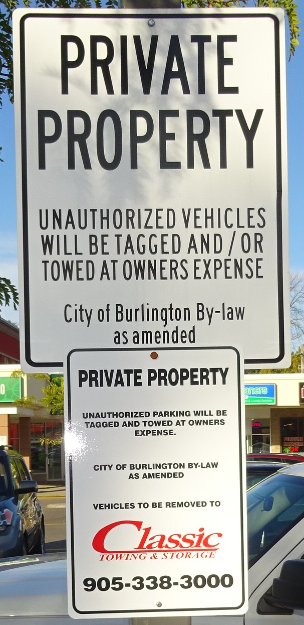 Parking signs are not all that hard to see. The No Frills supermarket has signs posted on light poles in the parking lot – but many people feel they can park in the evening when the lot isn’t busy. Not the case.
What bothers some people is the way they pay the towing company to get their vehicles returned.
For those who pay their fine by credit card the fine is reported to be 265.00.
If you choose to pay cash you can apparently get a bit of a discount – they don’t collect the HST.
Wright’s friends were charged $265 to recover their cars. Wright reported later to the Gazette that she was “in line at the Fortinos check out later in the day and ran into a friend. I was telling her about what happened last night when the elderly lady behind me said “at the No Frills on Brant?!” Turns out the same thing happened to her but she was charged $350!!!! reported Wright.
 The public parking lot right behind Joe Dogs is closer than the No Frills lot – and a lot cheaper. Wright thinks “This all sounds pretty shady.”
Many feel that they should be given a warning, others would like to see Joe Dogs putting a notice on their door about the towing practice.
There is a public parking lot right behind Joe Dogs – closer than the No Frills lot.
 By Staff By Staff
January 4th, 2018
BURLINGTON, ON
Update:
The Halton regional Police Service are pleased to report that the missing elderly female (Margaret McCormick) has been found in the City of Burlington.
At 6:45 pm, police located the missing female in a wooded area south of Highway 403 and east of Highway 6. Train personnel from CN rail reported observing a person near railway tracks in that area and provided a location for police to continue searching.
The missing female was carried out of the wooded area to an ambulance and is being treated for hypothermia. She was conscious at that time while being treated. She will be taken to hospital for further treatment.
Halton Police are trying to locate an elderly female who suffers from dementia; she walked away from a senior residence in Burlington (Aldershot) this afternoon at approximately 2:30pm.
 Margaret McCormick – missing in Aldershot The missing person is not dressed appropriately for the current outdoor temperature.
She has been identified as Margaret McCormick (78 yrs) and is described at female, white, 5′ 2″, very thin build, blond/silvery shoulder length hair, hat with a green stripe all around it, blue sweater, blue jeans, red mittens, boots and was seen carrying a white garbage bag.
Police are urgently requesting the public assistance in locating this party with exceptionally cold weather expected.
Residents are asked to check their properties and out buildings in the chance she has tried to seek shelter from the weather.
Anyone with information on this party’s whereabouts is asked to contact the on duty staff Sgt at 905 825 4747 ext 2310.
By Pepper Parr
January 4th, 2018
BURLINGTON, ON
It was a different way of passing along the Good News.
The staff in the office of Burlington MP Karina Gould sent out a media notice that Gould would be hosting a small event with St. John Ambulance and the Halton Police.
We were invited to “ swing by” on Friday, January 19TH, 2018 at 11:00am at the St. John Ambulance office on 1048 Waterdown Rd, Burlington ON L7T 1N3
 Karina Gould in her House of Commons seat with former United States president Barack Obama speaking. Watch for pictures of Gould with her baby in the House. A due date has yet to be announced. Then the surprise – “Minister Gould will bring the car seat she plans to once she has given birth”.
THAT is new – good news.
We can all hope for an easy pregnancy (only a male can make a statement like that) and the birth of a healthy child.
Congratulations Ms Gould – you constituents will be delighted.
 By Staff By Staff
January 4th, 2018
BURLINGTON, ON
The third New Year levee will take place on Sunday January 7th from 1:00 pm to 4:00 pm., at the Art Gallery of Burlington.
The event is being sponsored by Member of Parliament Karina Gould and MPP Eleanor McMahon.
 A levee is an old tradition in Ontario. In many communities the levee is held at city hall and sponsored by the Mayor and members of council. A levee is an old tradition in Ontario. In many communities the levee is held at city hall and sponsored by the Mayor and members of council.
There was a time when it was a pretty formal event – not so with the event Gould and McMahon sponsor.
Burlington’s Mayor hasn’t been part of the event the first two years – no mention of his taking part in the 2018 event.
Perhaps the sponsorship will be broadened in 2019.
It is a fun event and the speeches are kept to a minimum. It’s a time for the political set to gather and do what the politicians and the political junkies do
|
|


