By Pepper Parr By Pepper Parr
January 16, 2019
BURLINGTON, ON
With one long, exhausting day, during which city council accepted the recommendation from the Planning department that came out of a dense and complex report from Dillon Consulting, the public and council move to the next phase of the city getting what the Mayor refers to as a ‘better grip on the kind of development that takes place”.
Many felt that getting the Land Use Study part right was essential – and that if council did get it right they could then move onto the Taking a Closer Look at the Downtown report; if they didn’t get it right there was no point in doing the second part.
It is too early to determine if council did get it right on Tuesday.
There were some surprises and still some confusion as to just what the process is for moving the boundary of the Urban Growth Centre and then – how does the city get rid of the MTSA designation that was slapped on the bus terminal ?
 Burlington had to have an Urban Growth Centre. It has to be a certain size. The boundaries of the Burlington UGC were determined by the province – the city wants to change those boundaries. The above are the current boundaries. Heather MacDonald didn’t come across as being totally committed to the level of citizen participation that the people who packed council chambers on Tuesday expected.
Some people were upset over the lack of time the public had to download a 135 page document and wade through it all.
There was a lot of data – making sense of it was the hard part.
 Heather MacDonald outlined the purpose of the Statutory meeting and, when needed, spoke to issues that needed clarification. Jamie Tellier, on the right aided while City Manager Tim Commisso observes. He said little. MacDonald said that there was no requirement to promote the Land Use Study meeting. One wonders why one of the two critical meetings, Taking a Close Look at the Downtown, was promoted mercilessly while the other got very little promotion.
 Councillor Bentivegna was brought up a little short by Chair Stolte when it wasn’t clear if we actually asking a question. It was nicely done. The Tuesday meeting was legally a Statutory meeting – something the city was required to hold and follow strict rules as to how the meeting is conducted.
It started at 9:30 and ended just before 8:00 pm – with breaks for meals.
Committee Chair Shawna Stolte did an excellent job of keeping things moving – she was able to curb Councillor Angelo Bentivegna’s penchant for asking questions that were less than clear.
There were conflicting statements from the Planning people on what the city can do about the Urban Growth Boundary (UGC) boundary and the status of the bus terminal.
Heather MacDonald did explain why nothing has been done yet. She argued she felt it was vital that she have motions from the city making it clear why they wanted a change. She also wanted evidence and data to support the request. The Land Use Study certainly has loads of data.
The understanding is that the province doesn’t care where the Urban Growth Centre boundaries are – but that the city does have a growth centre.
The consultants the city hired said the province has never said yes or no to such a request – because no one has ever asked.
Council was not prepared to direct the Planner to do just that. Such a request would be political and it would be appropriate for it to come from the Mayor to the Minister.
There is considerable concern over how the Planners decided to keep the Waterfront Hotel within the Urban Growth Centre. Don Fletcher, heavily involved in the Plan B initiative said he believed the “Waterfront Hotel + Old Lakeshore Road Precinct + Brant Main Street Precinct should be moved out of the UGC, and define a similarly sized area (roughly 11 ha or 10% of the total 106.4 ha) within a suitable precinct north of Prospect Street on Brant/ Fairview.”
The view of many is that the UGC should be moved north and not include the Brant – Lakesh0re area; that will be a different debate – and not an easy one.
 The John Street bus terminal has the same status MTSA – Major Transit Station Area as Union Station which everyone agrees is dumb, The city wants to have that status lifted from the terminal. As for the status of the bus terminal – it appears that this is something the Region can do on its own – and that any request for a change has to comply with ROPA – which is the Regional Official Plan Amendment.
Waiting until city council has dealt with the Land Use Study, which determines whether or not the Interim Control Bylaw is lifted. It is due to expire on March 5th. The ICBL has been an expensive experience for the development community and for one developer, the Molinaro’s quite unfair.
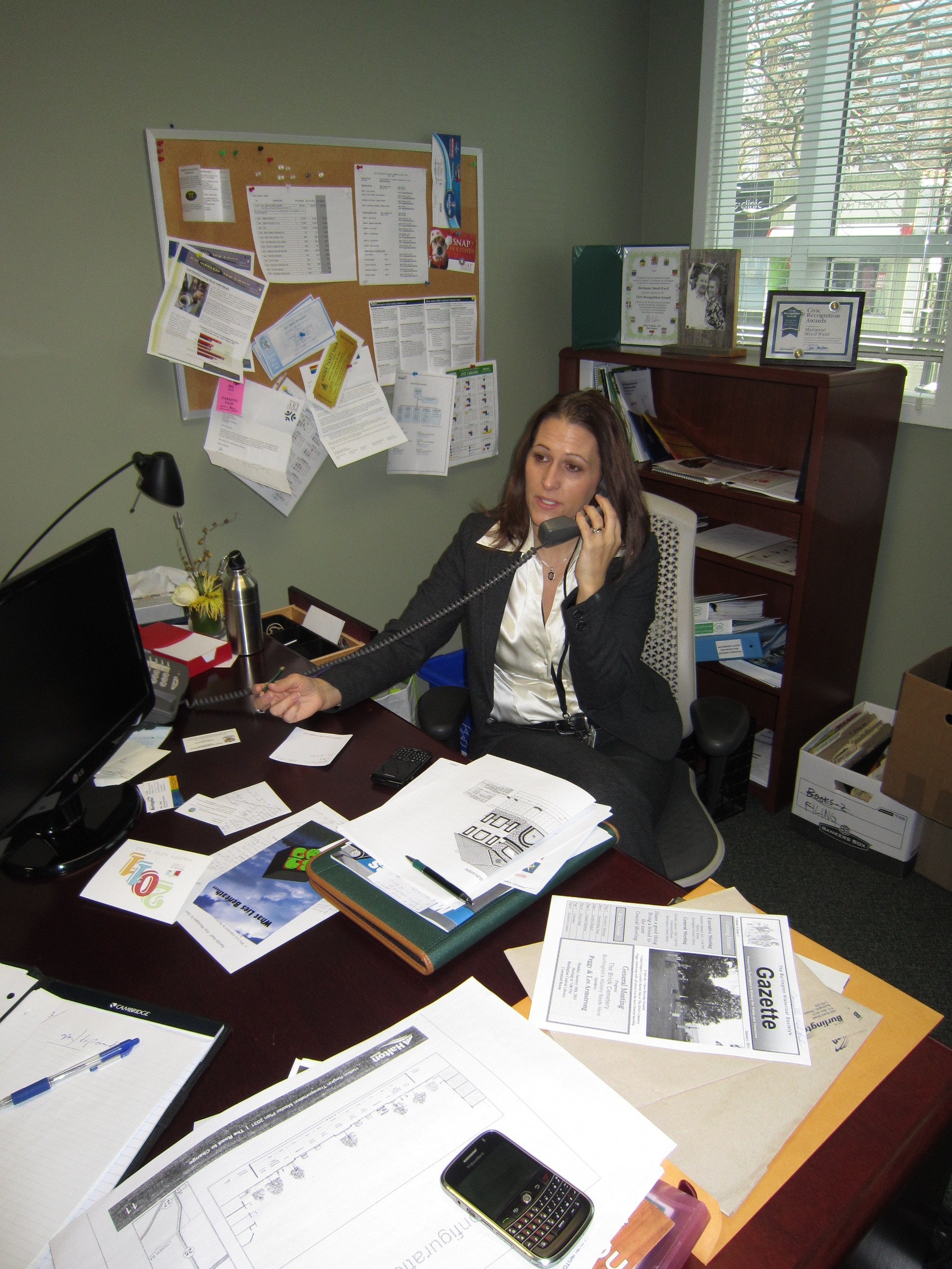
 Meed Ward in her first city hall office – the desk is as cluttered in her new space . Her eighth floor office is a lot more spacious and tastefully decorated. Mayor Marianne Meed Ward made her views crystal clear and pleaded for the community to trust council when she said: “It was identified in this study that there are significant gaps in our own policy and provincial policy. To be able to define the downtown bus depot that it doesn’t function the same as Pearson/Union (even though designated the same), it also doesn’t function as a bus depot. Now we have the evidence that this designation downtown is odd. I greatly appreciate that work from the consultant and staff. We now have a policy framework in front of us and can better manage the pressures of over development in the downtown. That’s what the community asked us to do & that is what this Council has done. I can appreciate members of the public don’t feel that way. I would plead to the community to hear us when we say we have heard you, understood & taken steps to control over development pressures. That was the start of this journey. We have independent research and policy tools to help us now. The one thing I think we all agree on is the downtown isn’t the same as the GO and will never be.”
Burlington MPP Jane McKenna jumped into the fray in January when she sent Council a letter that only served to further muddy the waters.

The day long Standing Committee sessions produce recommendations that go to a Special Meeting of Council for approval on January 30th.
Related news story:
Planning preferred concepts for downtown core.

By Roland Tanner
January 14th, 2019
BURLINGTON, ON
Glenn Nicholson delivered this delegation on behalf of Roland Tanner who was out of the country.
EcoB’s position with regard to the ICBL study is as follows. While there are elements within the report which we support, there is a key area where we believe the staff recommendation is in error.
 Roland Tanner, co-chair of ECoB taking part in one of the Action Labs that were part of the public participation events that were part of the Taking a Closer Look at the Down Report. Firstly, we would like to recognise the good work in the staff recommendations in their acknowledgement that the Burlington Go Station area needs improved zoning and height regulation. While we believe the Go Station is a far more appropriate location for a dense Urban Growth Centre neighbourhood connected to mass rapid transit, we do not believe this is an argument for bad development. For the Go Station area to become a vibrant new neighbourhood it is essential to have excellent zoning that insists on commercial space and retail and places reasonable limits on height. It is an opportunity for a truly complete community properly connected to transit. We support the staff recommendations in this specific regard.
Secondly, however, we do not support the recommendations regarding the downtown MTSA.
We acknowledge that current debate around the downtown MTSA revolves around which change is possible in which order. What these recommendations state is that we pass a new Official Plan and put in place zoning that builds the MTSA into all our city planning documents, at exactly the same moment as city planning staff have acknowledged that the John St bus terminal simply does not, never has, and never will function as a MTSA.
The staff solution to the assessment that the John St Bus terminal is not an MTSA perhaps makes sense from the perspective of municipal procedure, but it makes no sense from the perspective of logic or reality. The city must come into compliance with the Region, says the ICBL report, even if though, to put it bluntly, the Region is not in compliance with the laws of physics. The staff recommendation is therefore to continue to build the MTSA language into our planning documents, but to redefine MTSA, in this one instance, to mean what we want it to mean.
EcoB does not think this recommendation makes sense. To be flippant, if something does not look like a duck, or walk like a duck, or quack like a duck, and a consultant agrees that it is not a duck, and never will be a duck, is it really so unreasonable to insist that we stop calling it a duck immediately? If it’s instead large and grey and has a trunk and is a completely inappropriate resident of the local duckpond, does it make any sense to redefine the word ‘duck’ to describe something that everybody can see quite clearly is an elephant? We don’t think so.
 Debate centered to a large degree on the John Street bus terminal that most people didn’t think should have the status of a MTSA Major Transit Station area. Others want significant funds spent on upgrading the site. All the city has seen in the last six months is upgrade to the transit shelters. A better way to square the circle of legal requirements and practical reality would be to make a clear statement that Burlington does not believe downtown is or can be an MTSA, and that zoning and density targets should reflect the impossibility of major mass rapid transit ever coming to downtown Burlington, regardless of higher level designations.
Because the fact downtown is not an MTSA gets to the core of the entire debate we have been having in recent years. Places to Grow and the subsequent growth plans were all predicated on the sensible objective of placing people near mass transit. Oakville asked its Urban Growth Centre to be placed in midtown because its downtown could not support mass transit. Our council did not, no doubt still thinking in a car-centric manner of the proximity of the QEW exit, and not of what the province was actually trying to achieve.
Places to Grow and successive provincial governments asked cities to place intensification near transit. That is the alpha and omega of planning logic over the last 15 years or more. Rightly. Burlington has gone down a road of saying transit existed where it does not and cannot exist. Yes, even if shuttle buses can be provided, as they should, from downtown to key areas and transit hubs across the city, that will still not make downtown a major transit hub. Because of this fatal misdesignation, we are in fact concentrating development in a place the Province was at pains to avoid – somewhere separated significantly from a major transit node.
Surely the time to stop pretending downtown is an MTSA is now. Right at the moment when staff have acknowledged it is not – in any practical way – an MTSA. Not in two or five or more years when we can persuade the Region to change. And not after playing games with language which developers and LPAT are unlikely to respect or acknowledge and might well appeal.
In short, building more inaccurate language into our documents must be an error, and we urge council not to accept the staff recommendation on this matter.
Since every element of the logical basis for downtown designation for major intensification was based on the concept of mass transit, and since we have now established that logic was at fault, we therefore ask council to consider a formal motion to the Minister of Municipal Affairs and Housing making a public request for:
A) His clear guidance on how the downtown Urban Growth Centre can be urgently moved or modified, because of the faulty logic by which the UGC was first established.
B) How the province can work with the Region to speedily correct the error that was made when it designated John Street as a Major Transit Station Area.
 Burlington MPP Jane McKenna is said to have a simple answer on how to resolve the MTSA concerns. We have already received multiple indications from MPP McKenna that the Mobility Hub designations are within council’s remit to designate or undesignate, and we believe Council should do so as soon as practically possible.
Time is of the essence, and we cannot rely on the tortuously slow process of multi-year municipal planning revisions to deliver these essential corrections to the mistakes of earlier councils.
By Pepper Parr
January 14th, 2020
BURLINGTON, ON
Fifteen delegations; one lawyer threatening to sue, a private sector planner suggesting that the city planners might want to get some legal advice before they go much further was all part of the mix. The Council Chamber was packed – not even standing room.
One group of developers complaining that they have suffered a 40% drop in the value of their investment because of what they see coming in the way of changes being made to an Official Plan that has been approved but not adopted.
 Scott Snider – lawyer for a group of developers who he claimed were about to take a financial bath.  Councillor Paul Sharman Council Sharman gave a rather lame excuse for the serious failures of the 2014-2018 to do their homework and understand just what the province meant when the created MTSA’s Major Transit Station Areas.
The city had to spend more than half a million dollars on consultants who dove into the weeds and asked the necessary questions – they learned a lot and taught this council a lot.
The city’s solid core of delegations held Council’s feet to the coals and consistently reminded them why they were elected in 2018
The Interim Control bylaw will in all probability be lifted, and if not, several of the developments that were frozen will get an exemption from that bylaw. The Molinaro’s took a significant financial hit when the bylaw was passed.
 Patrick (Paddy) Kennedy and Justine Giancola from Dillon Consulting confer before answering a question at the Standing Committee that was debating the Land Use Study. The Land Use Study done by Dillon Consulting. while both dense and complex, has served the interests of the city very well.
It will take a little time for the flaws in the report to come to the surface – there are always flaws.
 Developers who invested heavily in land, especially at the Drury Lane end of this area – were shocked when they saw the height limitations that were going to be imposed. A group of developers were “shocked” (those were the words used by their lawyer) when they saw what the height limitations were going to be for land they had acquired. Those developers are not going to walk quietly into the night.
Council voted unanimously to receive and file the consultant’s report – but before Mayor Marianne Meed Ward put an amendment on the table – which got unanimous approval.
There is much more to say – a lot of detail – but it is late and I have to go home to let the dogs out for their evening constitutional.
At a Special Council meeting January 30th council will vote on what they spent the day talking about – expect the city to have made some good decisions.
Then the hard work really begins – they now have to deal with all those development applications that were stopped.
The developers, their planners and their legal counsel will begin figuring out how they deal with this new regime.
By Pepper Parr
January 14th, 2020
BURLINGTON, ON
 The 30th of January is going to be a very full day for Mayor Marianne Meed Ward. The 30th of January is going to be a very full day for Mayor Marianne Meed Ward.
She is scheduled to deliver the Annual State of the City address to the Burlington Chamber of Commerce. That events starts at 7:15 am and is scheduled to end at 9:00 am. The event will take place at the Performing Arts Centre.
City Council is scheduled to hold a Special meeting of Council to decide how much of the recommendations that will come out of the meeting held being held today, Tuesday and the meeting on the “preferred concept” for the downtown on Thursday they want to make final. That meeting is scheduled to be called to order at 9:30 am
The final approval of the two issues: The Land Use Study that was brought about by the creation of an Interim Control Bylaw that stopped development in the Urban Growth Centre and the Take a Closer Look at the Downtown; a report that will put forward where development should be permitted and what the height levels will be.
It has been going to be one heck of a week for the Mayor – and a turning point for the city.
There is a group in the city running a betting pool – will the Mayor wear red?
By Pepper Parr
January 2, 2020
BURLINGTON, ON
The doors to city hall were open this morning – it isn’t certain that a full complement is in place to get the wheels turning.
 Joan Ford, City Treasurer, led a team that brought forward a budget that was given a solid work over by Council – her team responded quickly and found ways to meet the 2.99% this council wanted. Many appear to be adding a couple of days to that magnificent period of time from the Eve of Christmas to the beginning of the New Year and returning to their desks on the 6th. There are a number of people, especially those in Planning and Finance who worked long hours responding to questions from council and revising documents – sometimes on the fly, who deserve any additional time they were able to get over the holidays.
The Clerk’s department has had its hands full; they will be dealing with a significant shake up at the leadership level – will the new Clerk come from within or will Burlington look for a seasoned Clerk elsewhere. There are a number of women in that department who could take on that job – the City Manager is one who could nurture one of several women who have shown considerable promise. A change in attitude within the department will be welcome for those who happen to deal with the Clerk’s office on a frequent basis.
Some members of council were making the best of that opportunity.
 135 pages long and dense + the appendices. The Mayor has said she would be burrowing down and working her way through the several documents that were part of the Land Use Study that was brought about when the Interim Control Bylaw (ICBL) was passed last March. The document and its appendices are not for the faint of heart; it will be interesting to hear what Council has to say when it meets at a Statutory Meeting January 14th.
Those who do read the document might well ask if the will of council has been fully discerned by the consultants who wrote the report and the Planning staff team that sent the report to Council.
 The Taking a Closer Look at Downtown report was a blurred image to many. They get another chance on January 16th to put up a clearer picture. Two days after the Land Use Study Statutory meeting council will see the second version of what might be included in the Re-examination of the Adopted Official Plan report that didn’t get a round of applause from Council when they reported to Council in December.
At the risk of appearing petty we wonder just how many members of Council reported the gifts they received from developers, National Homes appears to be the one looking for “por favour” from Council – they have two applications that are both at LPAT with settlements that have yet to be given the LPAT seal of Approval.
 Kearns chose to share the gift she got with her colleagues. Several of the Council members said that they didn’t accept the gift – instead passed it along to a community organization – except for Councillor Kearns who, after explaining in some detail that she does not accept gifts, went on to say that she shared the gift with others on the 7th floor – which is where we house Council members.
Roland Tanner, who actually reads critical documents that come out of city hall, pointed out that the Code of Good Governance , a document signed by every member of Council, as well as being the subject of a half day Workshop, states quite clearly what is to be done with any gift that gets sent along to a Council member.
One of the requirements is to report receipt of the gift to the Clerk, who is required to report annually to the public on who was offered what. We will watch for that report.
The October 2018 municipal election gave the city a new set of wheels to move forward on; the electors chose the candidate for Mayor they believed could best bring about the change they wanted. There was no doubt about that vote.
The five newcomers have had the time they needed to get to know and understand each other; appreciate the different strengths and weaknesses and create some common cause.
In the first six months of 2020 they are going to have to make some very significant decisions – the response to the Land Use Study, getting a rejigged Official Plan in place and sending a stronger message to Staff on just what the will of council is and making sure they understand just what that will is and that it is adhered to – we aren’t there yet. Several news stories and opinion pieces we will publish in the days ahead make that point quite clear.
 Proposed for the eastern gateway to the downtown core. The city and its bureaucrats need to make it as clear as possible to the development community that Burlington is not a community where anything goes.
 Mayor Marianne Meed Ward: Much more than a pretty face. Mayor Meed Ward has shown that she knows how to take the gloves off and land a solid punch on the nose – when the Grow Bold mantra had lost favour and whatever charm it had, the planners were a little slow in getting the message. Meed Ward made the course correction that was necessary when she said: would “provide absolute clarity to staff and to the community that the City of Burlington staff are not to use the adopted 2018 plan in evaluating current/new development applications. Multiple analyses by staff in assessing development applications, downtown in particular, have made it clear we do not need to over intensify in order to meet our obligations under the Places To Grow legislation.”
 It is going to be an interesting six months – far too early to suggest that the year will be: a great one for the city – although the potential is certainly there. It is going to be an interesting six months – far too early to suggest that the year will be: a great one for the city – although the potential is certainly there.
That phrase on the city crest Stand By is perhaps the appropriate phrase for the year.
And lastly – do the police have Sean Baird in custody ? And if not – why not?
Salt with Pepper is the musings, reflections and opinions of the publisher of the Burlington Gazette, an online newspaper that was formed in 2010 and is a member of the National Newsmedia Council.
Related news stories:
Mayor shows how to get a message to Staff
The gifts that shouldn’t have been accepted.
Come home Sean.
By Pepper Parr
December 23rd, 2019
BURLINGTON, ON
First published before Christmas; the location of the full report is shown at the end of the article.
In March of last year the city brought in an Interim Control By Law which put an immediate 12 month hold to any development proposals in the Urban Growth Centre, a boundary imposed on the city by the province,
The reason for the bylaw was the rate at which development proposals were flooding into the Planning department; the city was beginning to lose control over what got built where and was working with an Official Plan that was badly out of date and a zoning schema that needed updating.
The 2014-2018 City Council had passed a new Official Plan months before its term expired. That “adopted” went to the Region for approval. While the “adopted” plan was being considered at the Region the city held a municipal election – we had a new mayor and five new members on a 7 member city council.
Shortly after the council was sworn in the Regional government returned the “adopted” Official Plan to the city asking for what were some minor changes and added that the city could make additional changes if they wished.
The new City Council, with a new Mayor, took that opportunity to re-write the “approved” Official Pan. That re-write is currently taking place. In the parlance that is used by the planners these days the land use study will “inform” the re-write of the “adopted” Official Plan
While all that is going on the Planning department was told by Council to bring in consultants to help determine what should be done with the Urban Growth Centre (UGC)
 This map does not appear to be identical to the map we saw when the Interim Bylaw was being put in place. Waiting for some comment from the Planning department
The decision to impose an Interim Control Bylaw came out of the blue as far as the public was concerned.
For the Planning department and the senior levels of the city administration it was a move that had to be made.
Development applications were flooding into the Planning department – staff were overwhelmed and the city was in the process of losing the control it did have over what was developed, how high the towers were going to be and where they would be located.
The decision meant real financial hardship for at least one developer and a retirement home operator.
Heather MacDonald, Executive Director of Community Planning, Regulation and Mobility was given a lot of latitude and the funding needed to source a consultant – she was permitted to sole source for this task rather than have to go out to the market. Her budget was $600,000
It is a building that at one point was recommended for closure by the Transit department. It became a huge stumbling block for the city during an appeal the ADI Development group made on the site for the 24 storey Nautique. Heather MacDonald, said in announcing the release of the report “The recommendation to implement an ICBL was brought forward by City staff in response to two primary concerns, including growth pressures that continue to emerge for the lands in the study area and a need to review the role and function of the John Street Bus Terminal as a Major Transit Station Area (MTSA).
With the findings of the study in hand, the city has called for a Statutory meeting January 14th at which the public can delegate and Councillors can ask questions. Expect this to be a contentious meeting. Staff will listen, take notes and use what they hear at the Statutory meeting to prepare the recommendations that will be included in the Staff report they bring to Council later in the year.
Many were concerned that the report could not be produced in the one year time frame – MacDonald surprised many when it was delivered two months early.
The 135 page document with graphics galore needs time and consideration.
Mayor Marianne Meed Ward said she: “I will be reading the staff report and accompanying appendices overt the holidays and will have more to say in January. I welcome the public participation. This is another step in the process to get the community’s vision reflected in our downtown. We are well on track to completing this work when the one-year deadline on our ICBL is up
The purpose of the ICBL Study was to:
- Assess the role and function of the downtown bus terminal and the Burlington GO station on Fairview Street as Major Transit Station Areas
- Examine the planning structure, land use mix and intensity for the lands identified in the Study Area; and,
- As required, provide recommendations to the City on updates to the Official Plan and Zoning bylaw regulations for the lands identified in the Study Area.
In the report the consultants said:
“There is a strong policy basis for Burlington’s Downtown John Street Bus Terminal as an MTSA and hence the numerous policy documents at the Provincial, Regional and City levels which identify an MTSA in the Downtown. Lands within the Downtown Burlington are identified as an MTSA in the Big Move, Halton Region Official Plan and the City’s adopted Official Plan (but not within the in force Official Plan). Furthermore, a number of long range plans identify potential for transit improvements along Brant Street to enhance connectivity between the Downtown and Burlington GO MTSAs. The Province’s RTP 2041 includes a “Priority Bus / Priority Streetcar” corridor on Brant Street between Downtown Burlington and the Burlington GO Station; and Halton Region’s DMTR reinforces this opportunity, identifying the link between the Burlington GO Station and the Downtown as a Priority Transit Corridor.
The consultants added:
 Tough to describe the John Street bus station as a Major Transit Station Area. There was just an estimated 320 boarding/alightings in the am peak period. “From a policy perspective, the Downtown Burlington John Street Terminal is clearly understood to be a Major Transit Station Area. From an operational perspective the John Street Terminal is estimated to have 320 boarding/alightings in the am peak period, with potential to grow to 1800 boardings/alighting in the future. However, in comparison to the characteristics of typical major bus depots, the John Street Terminal has a number of limitations which underpin its lower ridership levels, including:
- Limited number of major trip generators in the Downtown;
- Limited connectivity to Burlington GO Station;
- Limited station infrastructure; and,
- Limited number of convergence and limited number transfers.
“With the above-noted limitations in mind, it is important to recognize that not all MTSAs are equal. The various density guidelines (e.g. Growth Plan density targets, Mobility Hub Guidelines and MTO’s Transit Supportive Guidelines) reinforce the notion that there is a hierarchy when it comes to transit, with facilities which operate in dedicated right-of-ways, such as subways, LRTs and BRTs, having the greatest potential for ridership compared to bus services which operate in mixed traffic. And while the current ridership levels are low, despite the fact that the Downtown is the City’s densest area, the John Street Terminal functions as a relatively important transfer point in the context of the City’s system.
“With this in mind, the station alone is not understood to be a significant driver of intensification, however, certain forms of intensification, such as employment uses or other major trip generators would help to reinforce the function of the MTSA. Furthermore, future improvements to services and infrastructure could help to improve ridership.”
 Shovels are in the ground. A development the city did not want, a development that began the high rise fever and alerted other developers with just what they could get away with in Burlington. That, unfortunately, was just the argument that the ADI Development Group used to convince the then OMB to approve their Nautique appeal. The idea that transit will be used by people who live in the downtown core suggests a huge failure to understand just how transit is used in this city.
Put a free bus running up and down Brant Street and people will use the service – you don’t need an MTSA to make that happen.
During a Standing Committee the public was led to believe that the Region could, if asked, declare that the John Street terminal was not a MTSA. The consultant also said that the province has never refused to permit a change in the boundaries of an Urban Growth Centre – but added that no one has never asked the Minister of Municipal Affairs to change a boundary.
This may be one of those occasions where that phrase GROW BOLD, would apply.
The Land Use Study has a number of graphics that give credence to that “a picture is worth more than 1000 words” phrase.
Two that will interest many follow.
 Top graphic is what the heights on Brant street now look like as you look eastward. Bottom graphic is the opposite direction.
 This is the elevations looking north from the lake.
 Where the height is located. We will return to a very important document – one that the Gazette believes has to be revised if the intentions of a majority of the current council are to be achieved.
The full report can be found HERE
Appendix B is the consultants report.
By Pepper Parr
December 29th, 2019
BURLINGTON, ON
The National Homes plan to build – what – on the 484 – 490 Plains Rd site where the Bingo Hall was located, is one of two developments they have before the city.
 484 – 490 Plains Rd site where the Bingo Hall was located. The Plains Road development is at Local Planning Act Tribunal (LPAT) where things are a little confusing.
There is an LPAT Settlement meeting scheduled for January 21st where the final stage of the agreed settlement between National Homes and Burlington was to be completed.
 Jim Young Jim Young, an Aldershot resident has been following this case closely and reports that “So far I don’t know any details nor do I suspect anybody else does.” Young is a Participant in the case.
Young adds that Tom Muir has been trying to argue a case that he as a “Participant” should be allowed to present an opposition to the settlement agreement. The National Homes lawyer, Ira Kagan, is advising Muir that presenting evidence is unlikely on two grounds.
1. Only parties get to present evidence or mount a case and there are only two parties… The City and National Homes. Participants like Tom or I can submit an opinion but cannot give evidence or present “Expert Testimony”
2. Since the city and Nat Homes have reached a settlement neither of them will need to present any testimony.
The appeal will open, there will be little or no discussion as there is agreement and LPAT will happily accept the settlement and move on.
Young concludes that: “At the end of the day what is agreed will be the outcome.”
“If we as citizens feel strongly enough opposed to it our fight must be with the city who we elect and who agreed to the settlement… not the developer over whom we have no control.”
 Tom Muir: He can be acerbic and difficult at times – but he usually has facts at his fingertips. He did not get a Christmas basket from National Homes. Most of the members of Council did. Muir takes the position “that some redevelopment of this site can occur, and is permitted by the existing OP, and while not planning policy relevant to this proposal, the proposed revisions to the OP and By-laws also permit some development”
“My concern is that this proposal is asking for variances that go far beyond these stated permissions and represent an over-intensification and over-development of this site. The key question is, when is enough enough? Unfortunately, there is so much scope of redundant, discretionary and arbitrary interpretation of the policy framework used to evaluate proposals, that almost anything can be supported and justified by assertions, based almost exclusively on intensification.”
Muir differentiates between “evidence-based policy-making” , and “policy-based evidence making. This looks to be the latter – decide what you want first, and then pick the evidence. Oftentimes, sections of the Policy Framework said to be used, are selectively chosen and focused to assertions that support the recommendation to approve.
“As a result, the viability of existing business and commercial economic development is being sacrificed by planning justifications such as this one. What I continue to find disturbing is the continued de-commercialization of Aldershot. In this respect, the impacts of the loss of commercial at this site are completely ignored in the planning justification coverage of the Provincial Planning Statement as part of the policy framework.”
The Provincial Policy Statement states that Planning authorities shall promote live/work, economic development and competitiveness by:
a) providing for an appropriate mix and range of employment and institutional uses to meet long-term needs;
b) providing opportunities for a diversified economic base, including maintaining a range and choice of suitable sites for employment uses which support a wide range of economic activities and ancillary uses, and take into account the needs of existing and future businesses.
“I do not see these directions being followed in the proposal by National Homes focused on population intensification. In this regard, the proposal includes 10,748 square feet of commercial, whereas there is almost 50,000 square feet existing, and this commercial is fully serviced, providing maximum potential of uses, with commercial venting, full transport loading facilities and size, adjacent, or nearby, more than sufficient parking, and so on”, said Muir.
“There are no specifications as to what quality of commercial potential is proposed. Moreover, this seems to be inadequate replacement commercial space, and appears to resemble what the development business calls “throwaway commercial”, provided to get the real goal of intensified residential. Concern about the rent for new commercial space. A public meeting was told that: There is an option for existing tenants to move into new space and that the market will dictate size of units. New development will be set at market prices.”
Muir points out that existing prices are well below market rates and said: ” I have talked to existing business and they say that the rents will double and become unaffordable.
The proposal asks for very significant amendments to the Official Plan and By-Laws asking for increased height, increased density and increased floor area ratio, reduced minimum setbacks, reduced amenity area, and reduced parking standards. The Planning Justification for the proposal only mentions the floor area ratio (from 1.5 to 2.14); net residential density (from 51 to 185 units/ha, to 216); and height (from 2 to 6 stories, to 8) but claims that except for these variances the proposal conforms.
 Tom Muir: It should be about good planning. There is increasingly a departure from the reality of multiple car ownership per unit. I agree that not every unit will have 2 or more cars, but it’s just fantasy to say and assume that all units will have mostly 1 car, and thus dismiss the parking issue that is a reality. At the present time, residents in the Jazz building across the street are reported by residents and business nearby to be parking in the proposal site at all times of days and overnight. As well, parents of children at the school across the street also use the site to park as they pick up and drop off their kids. All those thousands of unaccounted for vehicles are not going to disappear because the planners refuse to recognize they exist.
“This is not “good planning”, but is making convenient and false assumptions to facilitate what the planners want to do. It’s the residents that are being subjected to the consequences.”
By Pepper Parr
December 19th, 2019
BURLINGTON, ON
The good news is that the Interim Control Bylaw (ICBL) Land-Use Study was produced within the one year time frame Heather MacDonald, Executive Director of Community Planning, Regulation and Mobility, said it would be done in.
It will be formally presented to Council at a Statutory meeting on January 14th. In the meantime the report – 135 pages long – will be closely read and re-read by the development community, their advisors and their legal counsel. All those billable hours will be racked up and billed before the end of the year.
Too early to say whether or not this is a gift to anyone.
 Heather MacDonald, Executive Director of Community Planning, Regulation and Mobility In a statement released by the city, Heather MacDonald, Executive Director of Community Planning, Regulation and Mobility said: “The recommendation to implement an ICBL was brought forward by City staff in response to two primary concerns, including growth pressures that continue to emerge for the lands in the study area and a need to review the role and function of the John Street Bus Terminal as a Major Transit Station Area (MTSA).
Is this John Street Bus Terminal a Major Transit Station Area or just a place where you can buy a bus ticket? With the findings of the study in hand, City staff will come back to City Council on Jan. 14 with proposed amendments to the current in-force-and-effect Official Plan and Zoning Bylaw that will make it possible for new development in the identified study area to be better informed by the City’s transit, transportation and land use vision.”
The staff recommendation report and proposed amendments can be viewed online.
The full Dillon report is HERE
The purpose of the proposed Official Plan and Zoning Bylaw amendments is to:
• strengthen the integration between land use and transit by introducing policies related to transit-supportive development
• introduce the concept of Major Transit Station Areas and a policy framework
• introduce development criteria for development applications within the study area
• update or add definitions to the Official Plan to align with Provincial policy documents and/or assist in the interpretation of Official Plan policies
• introduce additional permitted uses and heights on lands near the Burlington GO Station.
A review of the Land Use study will follow – soon.
By Staff
December 10th, 2019
BURLINGTON, ON
No doubt now about what is happening opposite city hall.
 Tight fit on a small site. It’s a tight fit for all the equipment on the site – heavy duty drills that are doing foundational work and concrete mixers lined up to pour.
The marketing drive is well underway and Carriage Gate vice president Mark Bales shows up at city council to get the developer view point on the table.
 Drill ready to sink steel into the foundation of The Gallery. The Gallery, the name of the 23 storey condominium that will rise opposite city hall, is the first of three developments that have been approved and can begin construction.
Priced from the $400,000s to over $2 million, the suites at Gallery Condos + Lofts range in size from 600 square feet to 2,200 square feet and feature functional, open-concept layouts with large living rooms, gourmet kitchens and expansive balconies or terraces. Standard finishes include wide plank laminate floors, nine-foot ceilings, two-tone kitchen cabinetry, polished quartz countertops and a modern porcelain tile backsplash.
ADI’s, the Nautique, now has mesh type hoarding around the site – can’t see a thing.
The development south of the Gallery, approved for 17 floors, at LPAT looking for 23.
The Bridgewater does have some work being done on the site – still no clear answers to the questions that are being asked.
By James Young
December 9th, 2019
BURLINGTON, ON
I attended The Planning and Development Committee on Thursday when Councillor Bentivegna expressed his controversial “disappointment” with a delegation.
 Lynn Crosby and Blair Smith delegating at city hall. I heard presentations by city planners and consultants, one doesn’t have to agree with them to find them informative. I heard informative delegations from Lynn Crosby and Blair Smith of “We Love Burlington” and Don Fletcher for “Plan B”, the conscience of our waterfront. I heard self-serving delegations from developers and their professional associations, leaving me wondering: Do developers from Hamilton or Toronto deserve equal consideration with local residents who have to live with the developments long after developers have moved on?
In the evening session I heard a detailed delegation from Gary Scobie, who provided councillors with a concise, accurate and informative planning history of Downtown. I hope council and staff learn as much as I do every time Gary delegates.
Roland Tanner, for Engaged Citizens of Burlington, gave an intelligent dissertation on the compromise inherent in the staff recommendation, to get the Official Plan done now and fight the Major Transit Station Area (MTSA) and Urban Growth Centre (UGC) designations later.
I loved David Barker’s idea of a pedestrian area at Lakeshore and Brant St.
Coming from Glasgow where, in the 1970s, Sauchiehall and Buchanan Streets were pedestrianised and closed to traffic. On a Burlington scale: this is the equivalent of closing Lakeshore from Guelph Line to Maple Ave. and Brant Street from Fairview to Lakeshore. Despite the hue and cry at the time about where will cars go? How will local businesses survive?
Fifty years on, these streets bustle with successful retail, patio cafes and restaurants, buskers on street corners, making it one of the most vibrant and attractive pedestrian precincts in the world. So closing Brant from Caroline to Lakeshore as a pedestrian precinct seems easily achievable if the city will is there.
 Gary Scobie during his delegation. Then there was the “disappointment” that councillor Bentivegna expressed at some of Gary Scobie’s delegation. This seems to have outraged some Gazette contributors.
I disagreed with the councillor. Gary was spot on in his summation of the Downtown OP Review. But was it outrageous or disrespectful? Have we reached a stage in our sensitivity that any criticism or response to a delegation is somehow offensive? What I saw was a poorly thought out point from the councillor, very ably responded to by Gary in what he later described as the normal thrust and parry of council/delegate debate.
My take on outrage is: “Commentators may not be more outraged than the victims.” I happened to be sitting with Gary and Roland Tanner when Clr. Bentivegna stopped by to discuss their delegations. Neither Roland nor Gary were outraged or offended. For those so outraged by a single word, cast your minds back to a time when five of seven councillors repeatedly offended and were downright rude to delegates like Gary, Tom Muir, Lynn Crosby, myself and many others. While I understand and respect Clr. Nisan’s desire for decorum, perhaps he was a little quick on the draw in this case.
 Angelo Bentivegna I was actually more offended when Clr. Bentivegna appeared to question the legitimacy of Roland Tanner’s ECoB delegation, while he accepted the presence of We Love Burlington and Plan B groups without question. Perhaps he should reflect on the influence of ECoB on the outcomes of last municipal election and be quietly thankful.
I leave readers with two thoughts on the Downtown Proposals:
If an OP is approved based on the existing designation of downtown as a MTSA/UGC, then those designations are rescinded, doesn’t that nullify that OP?
Might developers appeal that at LPAT?
Might the Province or Region resist undoing those designations on the grounds that the new OP was approved based on those designations?
I also worry that the planner’s two options are based on provincially mandated “average” UGC density targets of around 200 people or jobs per hectare. Yet developers will still apply for amendments on a case by case basis, most of which considerably exceed that number.
Judging by past appeals it appears that LPAT adjudicates on this case by case basis, regardless of Official Plan’s average densities. This will inevitably lead to over intensification which will strain infrastructure, roads, transit, traffic congestion, all of which are planned around that 200 average.
 James Young is an Aldershot resident who has delegated at city hall frequently. James Young is an Aldershot resident who has delegated at city hall frequently.
By Roland Tanner
December 5th, 2019
BURLINGTON, ON
This is the delegation I gave at City Hall yesterday on behalf of ECoB. It is, in essence, already obsolete, which I believe is good news for residents. It is obsolete because Council informally signaled its clear intention to get the Official Plan Review process complete in March 2020, to lift the ICBL, and move on to doing everything in its power to take on the Urban Growth Centre, Mobility Hub and Major Transit Station Area (MTSA) designations which currently give additional powers to developers to build what they want.
This may still not be the Official Plan most residents want. In fact I’m sure it’s not. Because the city alone cannot insist on the OP residents want – yet. But if the city can persuade other levels of government to work with us, there is some hope that the clearly expressed preferences for residents for downtown Burlington can still be achieved. Nobody should pretend it will be easy. What residents have asked Council to do in reshaping and removing the downtown designations has never been done before, and there is no formal process to achieve it. But getting the revised OP back to Halton Region in March gives us our best chance of achieving those difficult objectives.
I am delegating today on behalf of Engaged Citizens of Burlington. Engaged Citizens of Burlington is a registered non-profit organisation with over 600 signed up supporters, a growing percentage of whom are paid members. We advocate on behalf of the proper recognition of residents’ preferred solutions in all municipal matters, in favour of a stronger role for residents’ voices generally, and in favour of the reform of the province’s relationship with municipal government.
 Tanner on ECoB: We exist because the voices of residents have historically had a hard time being heard at City Hall over the last decade or so. That’s the same phrase I’ve used to start the last three or four delegations I’ve made here. I say it because not everybody in the audience knows what ECoB is, and also to counter the criticism of ECoB made since its early days, and still made frequently on Twitter: namely, that we are a group of angry, unrepresentative and entitled NIMBY’s who represent nothing but selfishness.
We exist because the voices of residents have historically had a hard time being heard at City Hall over the last decade or so, and still need all the help they can get in working, hopefully collaboratively, with City Hall.
But that’s not the same thing as saying ‘what residents want to happen has to happen’. What residents want can only ‘happen’ if it’s legal. But Council can insist on Official Plan that’s ignores the wider planning context, if it wants. It has that right. I suspect that’s the subtext of today’s debate, rather than the two options actually on the table. Should council send these options back to staff for a third time and demand options that reflect what residents want? Or is there another approach that could work?
So I’m not going to do what once would have been expected from ECoB and shake my fist and say that the options presented by staff are an outrage that ignores residents. I’m also not here to capitulate and say this represents a reasonable compromise with the public vision for downtown and we simply have to put up with it. It’s not and we don’t. Downtown’s future should reflect the vision of Burlingtonians. Period. Nobody in this room should have a problem with that. The only question is, how do we get there?
I believe we have two options presented by staff which are a good faith attempt to do what they can to deliver a compromise between what residents want and what is defensible at LPAT. But those options were never going to be popular or reflect the entirety of what residents want. That was very clearly signalled by staff throughout this review. They feel it would be professionally unacceptable to draft a plan that’s inconsistent with the provincial framework.
Why do they believe this? Because of the Urban Growth Centre. That’s the root cause of this entire debate. Regardless of population targets and minimum densities and all the rest of it, while the Urban Growth Centre is in place downtown we are going to get proposals for highrises, and LPAT is going to approve them. That Urban Growth Centre was put in place with little or no consultation, and absolutely no foresight in 2007. The then director of planning was proud that Burlington was the first city in the GTHA to do so. In retrospect it seems like we were first because nobody on that council was paying attention. But that decision informs everything happening now. Everything comes back to the Urban Growth Centre.
So Council has a choice to make, and very little time to make it. The choice is – either, ONE, reject both these options and ask the planning staff for a third time to reconsider their proposals for downtown. Or, TWO, let these options go forward, acknowledging that this is not what residents want, and not what many feel they have the right to expect, but recognising that if we’re actually going to win this battle for a downtown residents like, it’s not going to be the OP that delivers it.
If Council asks staff to think again, if that’s being considered, what will happen? It will mean more delays, with no particular guarantee that staff will even then come back with options that anybody likes. And I presume it will mean the Interim Control Bylaw will be extended, possibly for up to another year. If that happens, my understanding is that council remains unable to address the Anchor Mobility Hub at the John St Bus shelter or the Urban Growth Centre. Everything that has a chance of definitively getting control of downtown remains on hold.
 What Brant Street could look like. Meanwhile development applications keep coming in. And they keep getting taller. And while the ICBL is in place the clock keeps ticking on applications, which means those applications are going straight to LPAT for non-response by council. Far from controlling the decisions on those developments, Council is handing them over to LPAT without trying to use the tools at its disposal to achieve moderation. Those developments are not coming back to you. LPAT will make the call. I freely admit that if I was sitting where you’re sitting I would have voted for the ICBL. I have no doubt. But right about now as I see developments being appealed to LPAT for non-response I’d be wondering if I’d made a mistake. I hope I’d have had the courage to change my mind rather than doubling down.
If in contrast Council takes these options and goes ahead with them as the basis for an imperfect OP for downtown, what will happen? The ICBL will be lifted. The city can, we believe, remove the Mobility Hub and leave central Burlington with one perfectly logical transit hub, taking one tool away from developers. The city can start making decisions on the developments coming before it, and residents need you to do that work. The city can begin lobbying the province for help with the Urban Growth Centre.
 Roland Tanner sees hope for the city. Yes, we know it will not be easy, and there are numerous hurdles to achieving it. But council has something very powerful in its pocket – votes in a marginal riding. We live in a must-win riding for any provincial government, and the current government is on the wrong side of the biggest political issue in our city for this or many generations.
In that context who can say even this pro-development provincial government won’t be willing to listen?
This is EcoB’s position right now. Complete this process as soon as possible and get onto the policies which address where the real power lies. Residents ultimately don’t care about a perfect Official Plan. They care about their downtown, and they want to see a council that is doing everything in its power to address the the many things which are currently taking their downtown away from them.
And if, finally, the Urban Growth Centre can be addressed and placed where it makes sense – where Burlington’s transit already exists and growth is already being focused – could we not then return to the OP and revise it to reflect the new tools that the city holds?
By Staff
December 6th, 2019
BURLINGTON, ON
Don Fletcher stood before a Standing Committee to tell them about a Citizens Plan for the Waterfront Hotel site at the foot of Brant street that is already in talks with the city to re-develop the site.
The Planning department had put out their proposed Concept 2 for the site. The creation of that proposal is what brought the Plan B into existence; they knew something much better was possible.
 The city Planning department called it the emerging preferred concept 2 On November 28th, 2017 an alternate building design featuring:
i. Extension of Spencer Smith Park
ii. Enhancement of Brant Street gateway to Lake Ontario
was put forward.
One June 5th, 2018 another Fletcher delegation resulted in amendment to key policy direction to “define & consider a building setback from the Thin Red Line”
 That thin red line would ensure that there would always be a clear view of the lake from Brant Street. The Citizens’ PLAN B remains committed to process, continuing dialogue with all stakeholders.
The Thin Red Line at NE Corner of Lakeshore & Brant is meant to ensure that there are no building West/ Southwest of Thin Red Line.
Fletcher explained to Council why the PLAN B folks were once again before Council.
– Two precincts, the Brant Main Street and the Lakeshore Mixed Use border on Waterfront Hotel property and Spencer Smith Park.
– That is a concern because changes to the adopted OP for downtown and the intensification designations will impact the application and approval of the Waterfront Hotel redevelopment
The participation that Fletcher saw at the Citizen Action Labs sessions caused the Plan B people additional concern about the process
The Re-examination of Adopted OP Process has a number of assumptions including key designations remaining unchanged.
– John Street bus terminal = Mobility Hub/ Major Transit Station Area
– Downtown Burlington = Urban Growth Center
• Both Concepts 1 & 2 seem designed to meet same intensification goals as former Adopted OP – LPAT defensible.
– Tall buildings permitted in Lakeshore Mixed Use Concept 1 at both NE corner w/Brant & NW corner w/Locust transition poorly to neighbouring precincts, but yield higher density
– Podium setback in Lakeshore Mixed Use Concept 2 of only 3m is to compensate for lower density of mid rise building
Fletcher believes that the electorate voted on Oct. 22nd, 2018 for fundamental change to intensification levels and the enforceability of Official Plan.
He concludes that key OP policies should to:
– Preserve connections & views to the waterfront
– House mid to low-rise buildings downtown with taller ones toward Fairview
– Maintain small town character and preserve heritage
– Reflect the community’s vision for the area
Fletcher argued that many attendees at Citizen Action Labs viewed Concepts 1 & 2 as different versions of same over-development and added that a different result from the 2018 Adopted OP demands a different approach.
Fletcher is concerned that Proceeding Solely As-Is is a mistake.
An Official Plan recommendation, potentially uninformed by the City’s Land Use Study (This is the work being done while the Interim Control bylaw is in place) was not in his opinion a smart thing to do. The land use study is not due until early March.
– Should the Mobility Hub/ Major Transit Station Area (MTSA) or Urban Growth Center designation remains they will permit the over development of the downtown which residents dislike and voted against.
This allowd for continued grounds for LPAT appeals by developers to plan/ negotiate ever greater heights. That would mean a return to “business as usual”, supported by developer-friendly Bill 108, once ICBL moratorium expires
This is the Brant Street view looking south to the lake that the Plan B people want to ensure does not happen. Citizens’ PLAN B proposes that the city continue to refine recommended Concept (1+2)
• Create an alternate What-if Concept to support growth downtown, without Mobility Hub/ MTSA and Urban Growth Center designations
• Accelerate Land Use Study & publish
• Aggressively lobby Region/ Province to change MTSA & Urban Growth Center designations, to establish viability
• Seek public feedback (January-February)
• Present both options to Council in March
• Decide and submit OP for approval to the Region of Halton, dependent upon finalizing designations for downtown
Burlington’s Downtown is at a turning point.
Related news stories:
The first look at Plan B.
Send the Plan back.
By Pepper Parr
December 5th, 2019
BURLINGTON, ON
Shades of the previous council.
Ward 6 Councillor Angelo Bentivegna told delegator Gary Scobie that he was disappointed with the delegation he had made.
Before Bentivegna could finish his ill-advised comment – Ward 3 Councillor Rory Nisan spoke on a Point of Privilege and said he did not want to see comments like this being made.
This is the second time Bentivegna has given Scobie a rough ride – he made a snide remark a number of weeks ago, asking “What do you want – a play by play” when Scobie was asking for a little more detail.
Burlington is fortunate to have people like Scobie who take the time and make the effort to bring fresh ideas, hard questions and imagination to how the city could grow.
 Gary Scobie – asking a question during the Walking Tour that was part of the outreach to citizens by the Planning department. In remarks after the Bentivegna choice words Scobie said that everyone knows the city has to grow – and that the growth is needed – he just wanted to see the growth in the right places – in and around the Mobility Hubs.
He told Council that they came to city hall with hopes to put a lid on this.
“We are in a predicament – you are being asked to meet a target you don’t really like – then get rid of the target.”
Scobie who attends most of the public meetings attended the Action Labs and reported that people were confused with what was being asked of them.
He deserved better.
By Gary Scobie
December 5th, 2019
BURLINGTON, ON
You have been put in a very difficult position as a Council. You wish to please citizens with good development in our downtown, yet you feel you must also create a new OP that will kowtow to the Province’s demands and developer wishes to over-intensify the area of our city that people look to as central to our existence.
 Adjust the current OP to reflect the downtown density we really want.  This was the first nail in the coffin for our downtown. You are in this position because of failures of past Councils, dating back to the Council elected in 2002, which threw up its hands
in defeat when trying to re-vitalize the downtown and accepted help from Big Brother in the form of the Places to Grow legislation designation of the downtown as an Urban Growth Centre. That Council and the one following in 2006 welcomed further intrusion in local planning by accepting a questionable designation of our Bus Terminal as an Anchor Mobility Hub.
That Council was more interested in saving the City by building a pier instead. Just think what they might have accomplished if they’d focused on the downtown instead, or not.
 Part of the gift that kept on giving.  The first decision -and they just kept on coming. Fast forward to the 2014 Council who after turning down the Adi request to build a 26 storey skyscraper at Martha and Lakeshore, didn’t know how to defend the decision at the OMB and soon after in November 2017 gave Carriage Gate a gift that keeps on giving, the OK for a 23 storey building at 421 Brant that went way beyond the Op’s 8 storey limit and even beyond the 17 storey limit that was being pondered for an updated OP, all for the asking.
This was the first nail in the coffin for our downtown. Since then Council OK’d a 17 storey building at 409 Brant, again across the road from City Hall. I am almost certain that the developer-friendly LPAT will give in to the request for more height to match the 23 storeys of its neighbour across the road, leading to the Twin Towers of Burlington, a mockery of our OP and our City Hall.
Now we have before us tonight what I’d term Plan D, an attempt to please the Province, LPAT and developers with the over-intensification they desire and are prepared to fight for. And they have all the high cards in the deck and the high-paid talent to do so. No consideration of our current OP and the views of citizens who wish to keep our downtown to a human scale with retail buildings that are two storeys in height in certain areas and individual in character and façade.
When I see either of the two concepts, looking up or down Brant Street, I am reminded of a near faceless canyon of steel, brick and glass fronting sidewalks, with podiums that are a minimum three storeys in height and stores that have no character except for the name on the glass. So the D is for failure – failure to listen to citizens at labs and walkabouts like those that I attended. The D is also for Destruction because if either of these concepts (or a combination of the two) is accepted by Council, it will likely sound the death knell of our downtown, a complete replacement over time of the character we value on Brant Street.
 The Brant Street that was – can any of it be saved? But what did we expect, as developers have been buying up our retail street lots for assembly for years for a redo of the downtown in their image? With these concepts we give them free reign, with the blessing of the Province, to go beyond the minimum density goals of the Urban Growth Centre, Anchor Mobility Hub and Major Transit Station Area designations.
Developers can always claim they are only doing what the Province asked in intensifying growth centres. Unless this Council rids us of these designations we will see continued destruction of our downtown. And it hasn’t really started yet, so we have yet to realize what will be taking place. We only have vacant lots at 374 Martha and 421 Brant. Wait until the construction starts. We only have a stalled Bridgewater project on the Lake that hasn’t really impacted our congestion during construction like these others will.
But wait, there’s more. We have applications for 29 storeys at Lakeshore and Pearl, two 27 storey building applications for the Old Lakeshore Precinct and a redevelopment of the Waterfront Hotel waiting in the wings. The latter three are not even being considered in the concepts we have before us tonight. Why is that?
There is no defense possible at the LPAT by the City to stop them. So we are being sold a backup plan that can’t possibly work to save our downtown. There is only one plan that might work, but apparently we are still waiting for a report about talking to the Province to get us out from under the downtown-killing designations our previous Councils so passively accepted. We don’t need a report. We don’t need a Plan D. We need to hear from Council that it is talking now with the Province on moving the intensity away from the downtown and the Lake up to the three GO Station Mobility Hubs. In other words, put a halt on these concepts and show us some action to save the downtown.
 Please don’t tell us that you aren’t at least setting the stage with the Province.  If you don’t do something with our OP, zoning and heights revert to the current 2008 version. Please don’t tell us that you aren’t at least setting the stage with the Province because the Interim Control Bylaw is in place till March. By then the timeline shows we’ll have selected a concept and maybe even a new OP. This would be like giving the enemy their ammunition.
There is one more thing that you must do as well though – adjust the current OP to reflect the downtown density we really want and the heights we would be comfortable with once we regain control of our downtown growth plan. Looking at creating a Heritage District up Brant Street to Caroline Street might also be suggested, but according to Oakville sources this is a time and effort-consuming task that may or may not fly. If you don’t do something with our OP, zoning and heights revert to the current 2008 version, the one conforming to intensification targets from the Places to Grow legislation. Only heritage buildings will be safe from being demolished unless this is done.
This is our last chance to stop many more skyscrapers from rising from Brant Street lots that will be cleared of the last remnants of unique stores and storefronts. Please don’t tell us these concepts are it – the plan to stop the high buildings. Because they aren’t.
By Lynn Crosby and Blair Smith
December 5th, 2019
BURLINGTON, ON
Good morning Chair, Councillors, Your Worship.
I am Lynn Crosby and with me is my colleague, Blair Smith, and we represent the advocacy group, WeLoveBurlington. WLB fought against the prospects of municipal amalgamation in order to preserve and protect local voice. We are here today because we continue to advocate for local voice. We believe that Council and the citizens in Burlington are at a crucial point where we have one last chance to fight for the vision of Burlington that citizens have been expressing for years. We have one final opportunity to protect our downtown, preserve our waterfront and ensure that the people are heard.
 Lynn Crosby in conversation with a citizen. While we applaud the committed efforts of Planning staff, we would like to add our opinion to that of many of the citizens of Burlington and express both disappointment and concern with the two options or “concepts” that are being offered for the development of the downtown core. We will leave discussion of our main issues for whenever Council will be endorsing amendments to the Adopted Official Plan. We have many technical and policy arguments which justify a more popularly supported vision for the downtown – we will offer them then. This morning, we would like to speak to fundamental flaws in the concepts.
 Where will the growth go? The Esso station site is reported to have been sold. WLB members attended two different sessions (hence received two different perspectives) of the recent ‘action labs’ designed to garner public opinion on what the vision and conceptual layout should be for the development of Burlington’s downtown. We also received feedback from several of our associates who attended different sessions. Notably, all sessions had the same deficiencies.
The two concepts (and the mention of a possible third melded concept) were presented – each based on the existence of the same factors or planning constraints:
The urban growth centre designation for downtown
The mobility hub located at the current bus station, and
The major transit station area designation
No consideration was given to any concept that was not based on and framed by these constraints. So, if these constraints change, and we believe that they should, then don’t the concepts also need to change? Indeed, if after the ICBL expires, and Burlington is successful in removing the classification of the urban growth centre or moving its location further north, then the limiting factors underlying the two concepts become irrelevant. Our fear is that if either of the options are selected for the downtown or anything substantially similar, then the relocation of the Urban Growth Centre becomes moot. You will be backing yourself unnecessarily into a corner that is inconsistent with your stated direction and intent.
Both concepts presented this morning are based on the Adopted Official Plan. The Adopted Official Plan reflects the direction and desire of the past Council. So, first we ask “what does this Council want?” Is the Adopted Official Plan your vision as well? The vision of the past Council, which we believe largely ignored what the people wanted for the downtown, should not automatically be inherited or repeated by you. To be fair, many of the errors made with regard to the future of Burlington’s downtown cannot be completely laid at the feet of the immediate past Council – they go further back. However, what does stand before you is the opportunity to correct these mistakes. This will be your lasting legacy.
In the ‘Action Labs,’ participants were told that the two concepts were developed because they were “defensible”. In other words, they would be consistent with the Provincial Policy Statement and satisfy the requirements of Halton Region as sole approval authority of the plan. But both concepts represent just slightly different flavours of the same thing – tall buildings in the downtown. Should there not be at least one true alternative? Participants were told that any concept that involved ‘no more tall buildings’ was not “defensible” and could not be included. So, when choosing a concept, participants selected the one that was the least offensive of the two rather than that which might actually reflect what they wanted to see.
Many participants that we questioned felt that neither concept was what was desired for downtown. Many felt that they were voting for the option that was ‘the best of a bad lot’; that even the informing vision for downtown (Section 3.3 of the Report) missed the fact, frequently expressed, that it cannot be achieved if tall buildings are part of the environment. This feeling of dissatisfaction with both process and available options is also apparent on the City’s facebook page where over 160 negative comments are registered. Overall, we believe this means any results from the polls and selections made by attendees are skewed and have little if any validity.
Perhaps the most fundamental question concerns the starting point of this process – the Adopted Official Plan. Why was this chosen when it clearly has neither legal status nor resonance with the citizens. Many who participated in the workshops had expected that this exercise was building a fresh view rather than one that merely “refines” an existing and frankly unpopular vision. Indeed, Section 3.4 of the report states that “the overall vision for the downtown remains the same”. Why? Add to this the fact that an Official Plan is intended to be read as a whole. The parts are interconnected and must be considered together to avoid taking things out of context. The downtown, which we are examining here and through this whole exercise, may be the most controversial portion of the OP but it is not the only one and each impacts the other.
WLB believes that the people need to be heard; that ‘tall building’ development in Burlington should not occur in the downtown core and particularly not in proximity to the waterfront. We will expand on this position whenever the final concept is brought back. However, we would like to be clear. WLB is not opposed to development in the interests of intensification but believes that this form of development should occur in areas other than the downtown core; if in the downtown at all, then much further north. The waterfront and our downtown are vitally important to our city and must be protected. The OP is the best way to protect them.
 Why, wondered Crosby and Smith, was the city using the Adopted Official Plan when it did not supposedly represent the current city council? WLB believes that Council should carefully listen to the voice of the people and defend it to the best of their ability. We believe that the new OP should be redrafted to present a ‘no more tall building’ concept for Burlington’s downtown core. Indeed, what is the rush? Why are we here now? There is no deadline in the Provincial Planning Act that is forcing us to push this through without sober second thought. We have been given a “time-out” to carefully reconsider what Burlington needs and what the people want. Why are we here today at the beginning of the Christmas season, rushing to execute on a consultant’s vision for our downtown with arbitrary deadlines and time-frames for response?
We read Mayor Meed Ward’s article piece published last week in Inside Halton about the recommended changes to the OP for the downtown. We were encouraged that she feels “they still represent over-development” and that she’s “looking for an option that is more in line with what residents have expressed throughout the OP process that began in 2017.” We note that Councillor Kearns appears to have similar concerns and are equally encouraged by statements in her recent Newsletter. We also agree that the Urban Growth Centre and Major Transit Station Area designations are a concern and should officially be removed or relocated.
This whole process to date – the Action labs, the downtown tours, the surveys, the one-on-one discussions with staff and council members – is rather meaningless since it was all predicated on a direction that we believe is flawed; the premise that the popular desire for no more tall buildings at all downtown isn’t defensible and thus can’t even be considered. And why? Because we have designed these options based on the current existence of the Urban Growth Centre and Major Transit Station Area being downtown, in fact they are “givens”. A circular argument at best.
And we should neither fear nor anticipate LPAT. We believe that at LPAT the position of a municipal Council is paramount. The hearing must first understand the position of Council and the relationship between this position and the existing OP and the PPS. The type of LPAT hearing to be held and the decision resulting can be totally based on Council’s stance and direction. The new or reintroduced issue is the ‘de novo’ hearing and we will get into detail on that when we delegate next. But the critical thing is the strength of Council’s voice and the consistency of its position. A good municipal lawyer will use this to maximum advantage. This position of fearless champion of what is best for Burlington is what we expect our Council to adopt.
Lynn Crosby and Blair Smith during their delegation: Were they heard? Finally, the result is that we feel that we are again not being sincerely engaged or truly heard. All the public engagement that has been done has landed us here in a position where the two concepts presented do not reflect what the public wants. We understand that Council will work with staff on modifications to produce an option for endorsement by early next year. This is far too important to be done in haste.
We respectfully request that Council take as long as is needed to produce the right solution for Burlington; one that protects the waterfront for generations to come and preserves a downtown free of any additional tall buildings. Please extend the ICBL if need be, complete the necessary studies, including the transportation study, the market analysis and the fiscal impact study, among others, acknowledge that the Official Plan is an integration of perspectives and should be addressed as a single entity. There is only one waterfront and one downtown – once gone there will be no bringing anything back and, fairly or not, you as a Council will be judged by the Burlington you saved or permitted to be lost.
By Pepper Parr
December 3rd, 2019
BURLINGTON, ON
It was a year ago this evening – the new city council was sworn in.
 City Manager James Ridge is shown the exit door. The next day the Mayor called a Special Meeting of Council and got their approval to fire the city manager.
There were other changes in the wind. The Council’s first budget increase was modest – but the Mayor had to convince her Council to shake $4million out of the hydro Reserve Fund.
That this was going to be a different council was made evident the night the Goldring Council held its last meeting. Meed Ward had some comments she wanted to make – Mayor Goldring politely advised her that comments were not permitted at that point. Marianne Meed Ward stunned the Mayor and the City Clerk that she wanted to speak on a point of personal privilege. While the Clerk was shuffling through the Procedural bylaw Meed Ward gave her a copy with the appropriate section marked.
And then she let blast. The full report of that meeting is linked below.
Paul Sharman was the only holdover from the 2006 through to 2018 terms; the others either resigned or were defeated. ( In 2010 every council member was re-elected.)
The other five were new to municipal politics. They had basically zero political experience and several had to struggle but they learned the ropes and little by little we began to see where there was some talent and where some help was going to be needed.
There was a new city manager who had served the city in the past; he was known, well-liked by most and was able to bring some stability to an administration that had gone through a very difficult period of time and knew that there were many rough months ahead.
 Mary Lou Tanner’s job disappears – she finds the exit door. The Deputy City Manager was shown the door; there was a new Chief Planner with a team that needed help and support.
The learning curve for the five new council members was steep; some are not doing all that well. Some have surprised us while others have been a disappointment.
What is evident is that this Council is pulling together and doing so rather well.
Collectively they are taking on huge issues – Climate Change was a challenge they did not shirk.
The opportunities to do things that were badly needed were embraced and while there is a lot that is not yet known – the outcome, whatever it is, will not be because this council didn’t try.
The members of council are learning the strengths and weaknesses of their colleagues; they are as well learning which Staff members are straight shooters and which are not to be relied upon all that much.
None of the five had any idea that the experience they are having is what they imagined the day they submitted their nomination papers.
The city’s downtown core is under an Interim Control Bylaw which means nothing moves forward until the research and the deep thinking is done.
 Official Plan gets re-write.  Might work in Mississauga – not wanted in Burlington. The re-write of portion of the Official Plan is taking place – with the Planning staff trying every idea out there to involve the citizens.
Some stunning developments have been brought forward; all of which would be embraced quickly by Mississauga – but Burlington is not Mississauga.
Council has to come to terms with wanting to do everything and what fiscal reality will permit. There are only so many Reserve funds that can be raided.
At this point council deserves to be told publicly that we appreciate what they are trying to do and wish them well as they enter their second year of their four year term.
A closer review however is merited.
The day Meed Ward let the outgoing council have it right between the eyes.
Salt with Pepper is the musings, reflections and opinions of the publisher of the Burlington Gazette, an online newspaper that was formed in 2010 and is a member of the National Newsmedia Council.
By Pepper Parr
November 28th, 2019
BURLINGTON, ON
It is amazing what can be done by a Mayor when they decide something has to be done.

The Meridian Brick operation on King Road has been a threat to the Tyandaga Community. They organized as TEC and raised tens of thousands to hire people who they believed could help them stop the quarrying that was going to take place for years close to their small back yards.
The previous council looked at the issue, said the quarry had a license to do what they wanted to do, shrugged their shoulders and let it go.
The Tyandaga residents were not prepared to give up.
They had worked with then Ward 2 Councillor Marianne Meed Ward who was elected Mayor in October of 2018.
On Tuesday of next week she will formally introduce several Staff Directions.
 The quarries as seen from the back yards of the West Haven residences. Direct the Executive Director of Community Planning, Regulation and Mobility to investigate the Air Quality Bylaw for Oakville and report back to council with a recommendation for a similar bylaw for Burlington by Q2 2020; and
Direct the Executive Director of Legal Services and Corporation Counsel to retain an environmental lawyer to advise on the municipal role in the Aldershot Quarry, the potential air quality bylaw and any other matters arising; and
Direct the Executive Director of Community Planning, Regulation and Mobility to review and report back on the peer reviews of the studies done by Meridian/Aldershot Quarry and requirements for ongoing monitoring and potential impacts on human health. As part of the review, report back on the cost and process to conduct an independent peer review of studies conducted to date; and
Direct the Director of Roads, Parks and Forestry to review the forestry plan for phased removal and replacement of trees at the Aldershot Quarry, and report back with an assessment to council in Q2 2020; and
Direct the Mayor to:
• write to the three local MPPs for Burlington, the Ministry of the Environment, Conservation and Parks, and the Ministry of Natural Resources & Forestry to request a meeting to discuss the conditions of the site plan and their oversight and due diligence in ongoing monitoring and studies conducted on the air quality impacts of the quarry activities to ensure the quarry is operating within provincial regulations.
• establish a Community Council Liaison Committee with representation from Meridian/Aldershot Quarry, local citizens, provincial ministries, city staff and council, and other stakeholders (as identified below), to provide regular communication among stakeholders, renew monitoring studies, and discuss quarry activities and any emerging/new issues.
 Bricks ready to be delivered. What a difference a Mayor makes.
The background on all this:
Meridian/Aldershot Quarry operates in the city of Burlington off King Road, north of North Service Road. The quarry is governed by both a provincially approved license and a site plan. The license was issued in 1972.
In 2010, a revised site plan was approved by the Ministry of Natural Resources and Forestry. The site plan spells out certain provincial conditions that must be met to continue operations.
Meridian Brick purchased the Aldershot Quarry in 1990. In 1998, the Tyandaga West subdivision, including what is now Westhaven Drive, was approved by the then-Ontario Municipal Board (OMB). The OMB-endorsed Minutes of Settlement included conditions for the plan of subdivision regarding ongoing monitoring of dust and noise, which were met prior to the issuance of building permits.
The west and centre cells of the Quarry are almost depleted, so Aldershot/Meridian Brick is now moving into the east cell, closer to the homes on Westhaven Drive.
Residents on Westhaven Drive, along with the broader Tyandaga community and beyond, formed the Tyandaga Environmental Coalition (TEC) and have raised concerns about the impact on human health from dust from the quarry. Additional concerns have been raised regarding loss of tree canopy and noise. Residents have asked whether the decades-old license would be granted today, or the subdivision approved today in such close proximity, given up-to-date information about the environment and potential impact of quarries in close proximity to residential neighbourhoods.
TEC is advocating for three actions related to the quarry:
1. Endorse TEC’s proposed Minister’s Zoning Order and Request for Review to allow for the permanent protection of the site, or at the very least the required three-year salamander survey work;
2. Seek, along with the Halton Medical Officer of Health, independent peer reviews of all Meridian’s technical studies, and
3. Commission a Stakeholder Design Charette exercise to explore sustainable rehabilitation and development solutions across the entire Aldershot quarry operation.
Requesting an MZO of the province would depend on the findings of the review of studies and ongoing monitoring requirements and oversight of the site. TEC has advised they have information about salamanders in the vicinity; we have requested they forward that information.
The city has recently taken the position with the proposed expansion of the Nelson Quarry that any post-use design discussion will not commence till the site is decommissioned; the same approach will be taken with the Tyandaga quarry.
There is merit in reviewing the studies that have been conducted, and the ongoing requirements for monitoring and provincial oversight.
In June of this year, myself and Ward 1 Councillor Kelvin Galbraith met with TEC members Fran Fendelet, Heather Lareau, Maria Rozakis Adcock and their consultant Dr. Franco DiGiovanni.
Mr. DiGiovanni is an expert in air quality, is often called on to testify at hearings (most recently on the proposed Milton CN logistics hub), and currently works for Hemmera, a leading environmental consultancy.
A number of issues were identified and shared by Dr. DiGiovanni regarding the quality of the studies conducted by Meridian Brick/Aldershot Quarry, and the nature of the peer review work that was completed, specifically:
– not conducted by a licensed engineer practitioner
– some contaminants were not examined
– unclear how Meridian is held accountable for ongoing monitoring
The issues raised by TEC, Dr. DiGiovanni, and citizens regarding the nature and quality of the studies done to date warrant the city taking a deeper look at the quarry activities, the ongoing monitoring, and the oversight provided by the province.
Former Mayor Rick Goldring and Councillor Rick Craven must be shaking their heads: they did nothing.
By Pepper Parr
November 29th, 2019
BURLINGTON, ON
Looks like things will get a little boisterous during the early part of December,
There are three Standing Committee meetings the week of December 2nd at which some contentious issues are going to be heard.
 Alison Enns, lead planner on the Taking a Closer Look Walking Tour  City Planner explaining some of the locations during a Walking Tour. The Taking a Closer Look at Downtown report that will be presented has a number of people disappointed with what the Planning team is bringing forward – they intend to delegate.
The Gazette is aware of two people – with several others wanting a little more time to think about what they want to say, registered to delegate. The report that is going to council is lengthy and at times confusing.
Alison Enns and another planner led a small group on a Walking Tour to gather thoughts and opinions from people and to answer questions. The two were quite keen and listened intently – there were a few points where they didn’t have much in the way of background on other developments in the area – the Bridgewater being a development where they didn’t want to say a word. What the public saw were two planners trying very hard to understand what people had to say.
 The council meeting was originally intended as a Committee of the Whole, a process that does not permit delegations. The complaints about that decision were close to visceral. For reasons that still aren’t understood the Clerk’s Office vacillated between ‘it would be a COW and then it would be a Standing Committee’. Some thought that concern was over people wanting to delegate which would take up much of the time. It certainly will – delegations are for as much as ten minutes and then as much as an additional ten minutes when the seven members of council ask follow up questions of the delegator. The council meeting was originally intended as a Committee of the Whole, a process that does not permit delegations. The complaints about that decision were close to visceral. For reasons that still aren’t understood the Clerk’s Office vacillated between ‘it would be a COW and then it would be a Standing Committee’. Some thought that concern was over people wanting to delegate which would take up much of the time. It certainly will – delegations are for as much as ten minutes and then as much as an additional ten minutes when the seven members of council ask follow up questions of the delegator.
This is the elected listening to the electors, folks; the reason we all stood out in the cold on Remembrance Day.
The point is – there will be delegations which we thought was the reason this council wanted to serve the public – so they could listen to them.
There is some concern as well over the report the Mayor will be making on her trip to Japan – the amount spent is thought to be over what was budgeted. We cover that in a different story.
By Pepper Parr
November 27th, 2019
BURLINGTON, ON
The map below shows the boundaries of all the proposed precincts.
The focus of this article is the Mid Brant Precinct that includes the No Frills Plaza
 Map showing all the precinct boundaries The Mid Brant Precinct is located north of Caroline Street and south of the schools and contains the NoFrills plaza. It was created out of the Brant Main Street Precinct and Downtown Core Precinct of the Adopted OP.
Vision The Mid Brant Precinct will serve as a mixed-use neighbourhood containing a significant amount of retail space including servicing a food store function. The precinct will function as a major retail centre that serves the day-to-day and weekly shopping needs of Downtown residents.
 Map of the Mid Brant precinct. To support a walkable community the entire area must provide an accessible and attractive pedestrian environment with wide sidewalks, and greenway connections to adjacent residential neighbourhoods. Future development will also result in the filling of surface parking lots and the intensification of under-utilized buildings.
Brant Street will be enhanced as a Pedestrian Priority Street with wide sidewalks, bringing buildings close to the street and small urban squares adjacent to Brant Street. An increased buffer will be provided along Rambo creek with a walking trail along the west side of the Creek. A new public urban park will also be created.
Brant Street frontage will have a low-rise character.
The east side will allow for 3 storeys within the first 20 m. Beyond 20m, tall buildings are permitted.
Concept 1:

A proposed extension of John Street to Victoria is incorporated beside Rambo Creek, which provides increased separation to low-rise neighbourhoods.
A step down in height along the west side of the John Street extension will provide a transition from the existing neighborhood.
Brant Street frontage will have a low to mid-rise built form.
Adjacent to Brant Street, low to mid-rise built form will be permitted in the first block depth. In the second block depth, mid-rise buildings are permitted.
A proposed extension of John Street to Victoria is incorporated in the centre of this precinct.
A step down in height along the west side of Rambo Creek will provide a transition to the exiting neighborhood.
Additional green space and a trail will be required on the west side of the creek.
 Concept 2. Concept 2.
This concept introduces a low-rise character to the Precinct which was not provided for in the Adopted Official Plan.
Includes a road extension of John Street to Victoria Avenue and requires transitional step-downs to the neighbouring precinct to the east which was not required previously.
Maintains low-rise character on Brant Street.
Tall buildings are permitted.
Additional green space and a trail will be required on the west side of the creek.
The concept introduces mid-rise buildings to the Precinct.
Includes a road extension of John Street to Victoria Avenue and requires transitional step-downs to neighbouring precinct to the east which was not required previously.
Allows mid-rise character on Brant Street.
As only mid-rise buildings are permitted, the block may not have a variety of built form.
Mid Brant is an area where re-development will likely occur.
 The Image above shows how 3 storeys are permitted within 20m of Brant and beyond that 17 storeys. The view is at Brant and Caroline looking north. The 3D Model Image above demonstrates the Mid Brant precinct where re-development will likely occur. The Image above shows how 3 storeys are permitted within 20m of Brant and beyond that 17 storeys. The view is at Brant and Caroline looking north.  The 3D Model Image above demonstrates the Mid Brant is an area where re-development will likely occur. The Image above shows how mid-rise is permitted along Brant. The view is at Brant and Caroline looking north. The 3D Model Image above demonstrates the Mid Brant precinct where re-development will likely occur. The Image above shows how 3 storeys are permitted within 20m of Brant and beyond that 17 storeys. The view is at Brant and Caroline looking north.
During a walking tour of this precinct Planning staff elaborated on what some of their thinking was. There would be a pathway along the east edge of Rambo Creek with benches in place.
The supermarket would remain but parking would be underground and some park area in the center.
Where would Joe Dogs go?
Related articles:
The outline
The bigger picture.
By Pepper Parr
November 27th, 2019
BURLINGTON, ON
The city’s Planning department is ready to take its first cut on what the downtown should look like. Council will review, discuss, debate and listen to delegations.
This article covers the available information on the Brant Main Street precinct.
While the overall vision for the Downtown remains the same, the Planning staff came up with two proposed concepts that are distinct and provide different ways in which to achieve the overall vision.
The two concepts are based on the revised Precincts. The development of the concepts is not starting from scratch. It was also necessary to take the following factors into account when developing the land use concepts: existing context; other related City policy; Provincial and Regional policy; and the directions given by Council for the re- examination including specifying 2031 as the planning horizon.
There are 11 precincts – two are administrative in nature – the others cover all of the downtown core.
Within each Precinct, there is an existing context of built and approved residential towers, office buildings and heritage buildings that is not anticipated to change before 2031 but which influences the character of the precinct.
The map below shows the location of all the precincts. More derail on the Brant Street Main precinct is below the ward boundary map.
 Brant Main Street Precinct applies to the portion of Brant Street that residents associate with the traditional downtown main street. Residents noted that the portion north of Caroline Street has a different character and it is now part of the Mid Brant Mixed-Use Precinct. Brant Main Street Precinct applies to the portion of Brant Street that residents associate with the traditional downtown main street. Residents noted that the portion north of Caroline Street has a different character and it is now part of the Mid Brant Mixed-Use Precinct.
Vision The Brant Main Street Precinct will serve as a unique destination within the Downtown and City-wide. It will be enhanced as a priority retail main street where the character of small retail shops lining the street is maintained.
Brant Street is identified as a Pedestrian Priority Street where the streetscape provides a safe and comfortable environment with Clear Path Zones and bump outs to narrow the distance to cross at key intersections.
A new large festival square, which is partially completed, will be located on the City parking lot between Brant and John Streets.
Permitted uses are primarily retail and service commercial uses on the ground floor with residential uses above.
Concept 1:
Brant Street will have a low-rise built form character.
Only low buildings will be permitted within the first 20 m. of Brant Street.
The remainder of these blocks adjacent to John Street and Locust Street will permit mid-rise buildings.
In addition to the overall Downtown vision, Concept 1 respects the low-rise built form character by permitting only up to 3 storey buildings along Lower Brant and parts of Lakeshore and extends it through Mid Brant.
 Concept 1 – would allow for taller buildings tucked in behind building that reflect the traditional Burlington.  Concept 2: Image above represent a 6 storey Midrise building, an example of what could be built The low-rise permission provides an opportunity for greater number of existing buildings to be maintained along Brant Street, while any new low-rise buildings will allow for greater flexibility in store sizes and unique store fronts, which provides the ability to maintain the eclectic look and feel that creates the unique sense of place of Brant Street. Mid-rise buildings are directed to John Street and taller buildings are directed to precincts north of Caroline Street and within parts of the Downtown East Precinct north of the Elgin Promenade.
 3D rendering of concept 1  3D rendering of concept 2 When reference is made to categories of buildings (i.e., low-rise) the following summarizes the range of possible building heights for each building type:
• Low-rise: up to 3 storeys
• Low-mid Rise: 4 – 6 storeys
• Mid-rise: 7 – 11 storeys
• Tall: 12 + storeys
Pros and cons of concept 1.
The Concept is most similar to the Adopted OP requiring low rise-built form character at street level but with a greater setback of 20 metres to mid-rise buildings.
Maintains a maximum 3 storey low-rise character along Brant Street.
Twenty-metre-deep building podiums provide flexibility to maintain existing retail stores or accommodate new retail space.
Allows mid-rise along John Street and Locust Street.
Concept 2: Mid Rise – an opportunity for an increased pedestrian realm and open spaces.
In addition to the overall Downtown vision, Concept 2 provides for a renewal of the Downtown through a low-mid rise built form along Lower Brant and Mid Brant and mid- rise built form along parts of Lakeshore. This ‘in between’ scale of buildings provides a human scale, walkable public realm that will provide opportunities for future gathering places and open space, through potential additional setbacks and privately owned publicly accessible open spaces (POPS1) along the vibrant streetscapes.
The taller mid- rise buildings allow for wider sidewalks and more open space at the street through greater building setbacks. Taller buildings are directed to precincts north of Caroline Street and within the Downtown East Precinct.
Currently no maximum height is identified for Tall Buildings. Input received through the engagement process will be used to inform the evaluation and confirm a maximum Tall Building height for each Precinct to be included in the preliminary preferred Concept.
Pros and cons concept 2
Compared to the Adopted OP, this concept permits shorter mid-rise buildings without stepbacks.
No stepback is required resulting in the potential for a 6-storey building to be introduced on Brant street.
Apartment towers limit flexibility of retail space due to columns.
Permits low to mid-rise buildings.
Related news stories:
The Outline
The bigger picture.
|
|


 By Pepper Parr