The developers are seeing the opportunities and are picking up bits and pieces of property just outside the downtown core.
The three homes that also serve as business premises on the south west corner of James and Martha, the ROCK Centre is just across the road, have reportedly been sold the Mattamy interests.
The three houses in the lower left hand corner are reported to have been sold.
The council member for the ward, ward 2, lives further north on Martha.
The Mattamy people built a large part of the Palmer Drive part of Burlington. They promote themselves as Canada’s Top Home Builder · Over 90,000 Homes Built ·
No word on just what Mattamy intends to build – just that at least one of the business operations will be out of their space by the end of December.
In November of 2016 Jim Young said to city council during a debate on the amount of time a citizen would have to delegate that: “Sometimes it may seem as if we delegates are the enemy of the process. That we somehow stand in the way of the great works and plans you all have in mind for the city.
“The democratic processes of our city demand that qualified, talented professionals like the city staffs and managers, we are fortunate to have in Burlington, apply themselves to a certain vision of the city.
“That they nurse that vision through the often tortuous process to council for approval and implementation, only to have someone like me, a citizens delegate, put a flea in council’s ear, a spoke in staff’s well-oiled wheel and force a review all of their efforts and the inevitable delay that brings.”
Jim comments on the most recent meeting of city council.
On Monday night Burlington City Council, ignoring the more than 1400 signatures on a petition and the 13 delegations opposed to it, voted to break their own rules governing downtown development and allow the development of a 23 story building in contravention of their own 12 Story bylaw. (Only one delegate, the developer, spoke in favour of the project.)
This was a sad display of council voting against the vast majority of citizen opinion, a rejection of local voices made even sadder by the fact that compromise may have been possible. Instead entrenched positions and a degree of “Not in My Wardism” were allowed to carry the day.
Jim Young delegating before city council.
We all know and understand that council cannot be swayed by every nuance of public opinion, we elect them to lead and expect them to do so, but in this instance the opposition was so overwhelming and the possibility of compromise so obvious that the wisdom of the five Councillors who voted for the amendment, in a the year before an election, must be seriously questioned.
Why, for instance, could the developer not have settled on 15 or 17 floors, there would still be ample profit in this, it would still meet intensification targets and be much less intrusive on the character of the area?
Why was there no offsetting land allocation for park or green space? Why does council not hold the developer responsible for affordability units in the development? (Only vague and non-binding considerations on affordability are embodied in the proposal)
While sensible intensification and increased density are supported by all of council, city staff and the majority of citizen opinion, last night’s decision to allow a development so far removed from the official plan, existing bylaws and any sense of building proportion, may well prove to be a tipping point in the eventual destruction of Brant street as we know it. Other developers have already snapped up adjoining properties and now have the green light on non-complying developments.
Ironically, the idea of downtown walk-ability and community vibrancy that the downtown plan seeks are the very things that will be destroyed by developments like this as the floodgates open and they become the new downtown.
On Monday night, there was palpable feeling that there may have been a settling of old scores between some members of council and ward 2’s Councillor Meed Ward. It would be a sad day indeed if decisions of this importance are based on past enmities. Hopefully, electors will such behaviour accountable in next year’s civic election.
Jim Young as he thinks through a point he is making at a transit meeting.
On the subject of elections, if I may be so bold as to offer Councillor Dennison some advice: Questioning the integrity of a well-intended citizen petition is just not smart politics. Even if a few of the more than 1400 signatures were not fully vetted, disparaging the integrity of the signatories as well as insulting a lot of citizens, ward constituents and voters, is hardly the way to encourage civic engagement by well-meaning citizens. If a few signatures were disqualified would 1399 have swayed you?
Mayor Goldring had to remind the gallery of the rules of decorum at the groans which accompanied one Councillor’s suggestion that this would not set a precedent for future downtown development, (by Wednesday, one more developer had requested approval to add two more stories to a proposed building at Locust and Elgin Streets) or that council’s rejection of citizen input is a template for future engagement.
While he insisted, we will listen in future and staff will listen in future. The groans from the gallery suggested: “Then why are you not listening now?”
Burlington City Council loves to parade their national and international honours and laurels for civic engagement. They now have to learn that when you talk the self-congratulatory talk you must also walk that walk!
When you ask citizens to come together, ask for their input, then, when they do, you overwhelmingly reject them, you can no longer claim that high ground on civic engagement.
You either listen to your voters and compromise or they will assume their voices are only heard at election time with all the future electoral consequences that entails.
The condominium that is to be built on the corner of Brant and James Street is to rise up to 23 storeys.
How many parking spaces, the number of elevators, how many, if any, affordable units – all that will get worked out in the months and weeks ahead.
We now know that the land assembly of the block to the south is all but complete – just the jewellery store to be acquired.
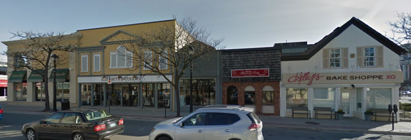
What we heard however is that the block to the south – the one that was once the Elizabeth Interiors operation – is going to be limited to 17 stories – a limit that is set out in the Downtown Core Mobility Hub that isn’t cast in stone yet.
That could be both a mistake and a missed opportunity.
We have yet to hear much in the way of negative comment on city hall as a structure. It gets referred to as “iconic” and the city planner likes the building.
Given that we are going to have high rise buildings can we not make the best of it. If the city hall is really “iconic” (I’ve yet to be convinced) then feature it.
While Burlingtonians hate Toronto being made a reference point – bear with me.
When you drive up University Avenue from Front Street and approach Adelaide there are two towers (Toronto type towers) on either side of the street. Both are Sun Life Assurance buildings meant to frame University as you go north.
Set aside that the two buildings on either side of University Avenue in Toronto loom over the street – it’s Toronto. Note the way they frame the street.
The photograph we have dropped in isn’t all that good but it makes the point. It is possible to have buildings in place that serve as a frame to what lies beyond.
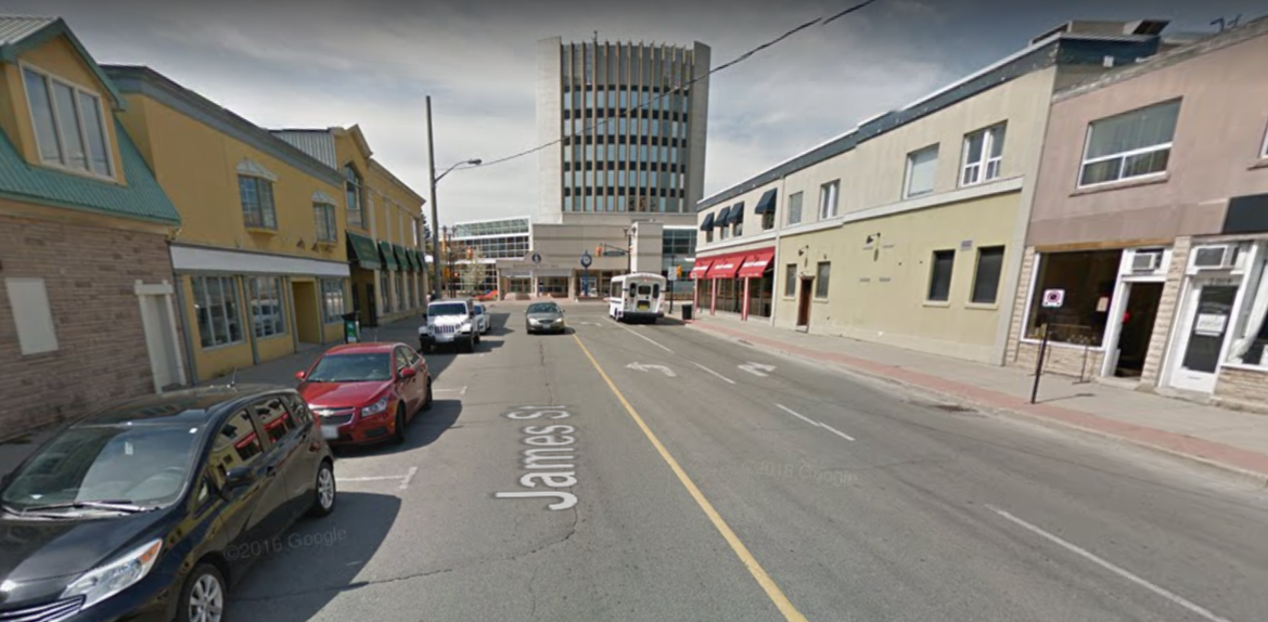
Now come back to Burlington and place yourself on James Street a block or two along the street and look towards city hall.
James Street looking west to Brant Street.
The current Carriage Gate building, on the right in the photograph, which is going to be turned into a 23 story tower. That is a done deal.
The property on the left, now the vacated Elizabeth Interiors store will fall within the rules that are going to govern the development limits for the Downtown Mobility Hub.
There is an opportunity here.
Someone with initiative and a desire to see something significant come out of the decision that has been made could pick up an idea like this and make a difference.
Why not work with Carriage Gate and Revenue Properties (the people who are assembling the block south of Brant and James) and build a better city.
Look for a design that is as close as possible to identical in design and have them rise to the same height. Same set back from the side walk; same trees, same patio set up, same sidewalk furniture.
The public art set outside each building would complement each other.
That is something that people could be proud of and perhaps change the way downtowners look upon their city. For those who need the quaint and historical the Queen’s Head and the old Russel Hotel will still be there.
Can the 421 project be more than just the first high rise tower in the downtown core?
Look at the Sun life building on University.
All this assumes that those opposed to the Carriage Gate building don’t take their beef to the OMB.
Well – we now know that there are going to be high rise – 23 floors plus – in the downtown core. That got decided at a defining city council meeting on Monday evening.
Ten years from now the city will look a lot different.
There is one development issue that could be even more critical to the development of the city, the look and feel of the downtown core.
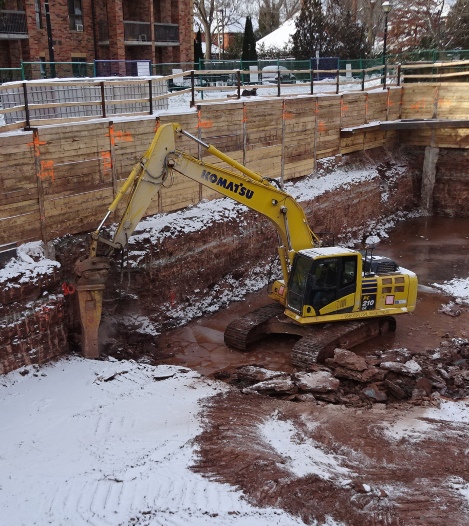
The Waterfront Hotel as we know it today is on the left – the red patch of excavation on the right is where the Bridgewater is being built.
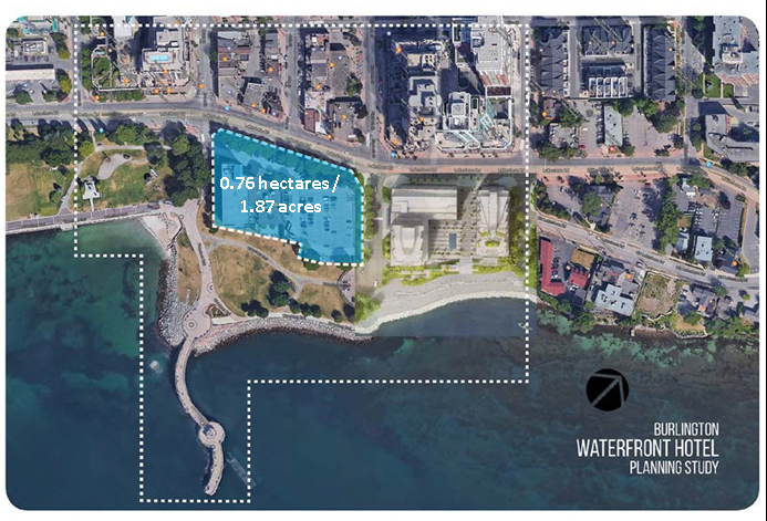
The city planners are currently working their way through a study of the re-development of the Waterfront Hotel property.
When the owner of the Waterfront hotel, Darko Vranich let the city know that he wanted to increase the density and add some height to the land there was an agreement struck that the city would hire people to come up with some design ideas. Three teams of designer/thinkers were to be assembled; two would work with the city – a third would work with the developer. And the developer would pay for all three studies.
A group of citizens have decided they are going to insert themselves into the process in a significant way. Several of the group live in the Lakeshore condos and they don’t want to see their part of the city go to the dogs.
No petitions from these people. They are hard core and they have done their homework and are putting ideas on the table.
The starting point.
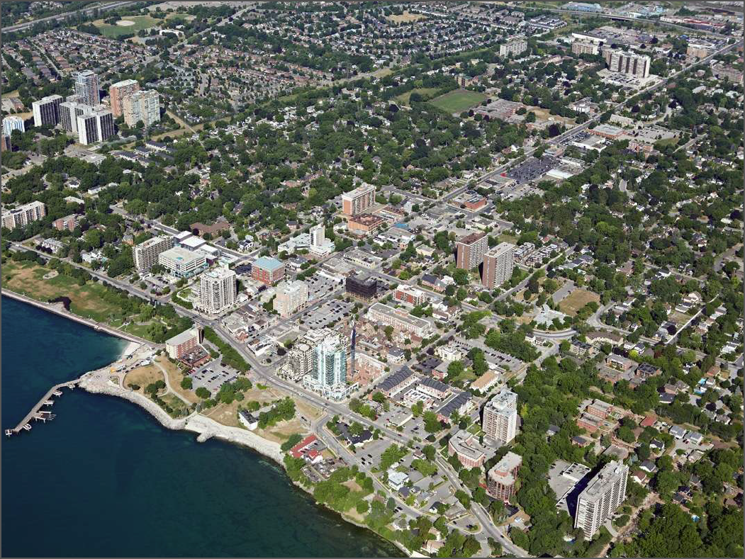
The site that is being re-developed is shown in dark blue – with a rendering of what the Bridgewater development will look like relative to the Waterfront Hotel.
The city has taken the public through an intensive community engagement process – all the meetings took place in the downtown area – what the people in Headon, the Orchard, Palmer and Alton think about what happens to the Waterfront Hotel property isn’t being recorded.
After a number of sessions where ideas were set out as sketched and then produced as rough models and made public.
The process started with three possible designs put forward: Two came from the city planning department and a third from the developer.
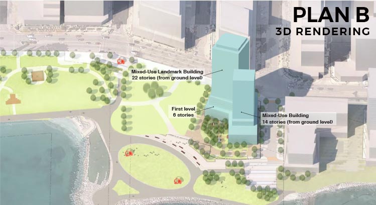
The Plan B people were not impressed – they came out with an idea of their own while the city produced what they called an “emerging concept”.
Let’s see what these all look like.
The early design concepts:
This is the first concept that came out of the Planning department. It shifts the focal point of the site from Brant Street to John Street.
This is the second concept that came out of the Planning department. It keeps Brant Street as the main road into the property but moves the towers to the eastern side of the property. Twenty and 30 floors was a surprise.
This is the design that was submitted by the property owner. It uses John Street as the entrance to the eastern end of Spencer Smith Park. The massing is to the east and west of the property. The suggestion that 40 storeys was acceptable has made many people gulp.
What the Planning department made of the three concepts.
The Planning department took the three concepts and what they liked from all the designs that came out of the community workshops and have given the public what is being called Planning Department’s Emerging Preferred Concept. The concept doesn’t suggest any building heights. The concept does make both Brant and John Street entrances. to the Park.
Not so fast say the Plan B people – more public space please and lower your sights on the height while you are at it.
The Plan B people saw it all quite a bit differently. They wanted far more space at the foot of Brant street and have the Pier show cased .
All this goes to a city meeting on November 28th.
There is an opportunity to do something spectacular – but it is going to take a city council that decides not to make the mistake made in 1995 when what is now the Bridgewater development decision was made.
What is interesting is the way many of the Waterfront Hotel re-development designs snuggle up to what is going to be the Marriott Hotel and the seven story condo at the foot of Elizabeth Street.
There are a lot of people who want to keep the quiet quaint feel of the downtown core. There isn’t going to be anything quaint about the waterfront five to six years from now. It could end up being very smart looking, swift, hip and cool. But getting to that point will be a painful process.
Ward 3 Councillor John Taylor was Ok with a 23 storey tower opposite city hall. His focus was on saving the waterfront view.
He called it the view the jewel of the city.
“The lake is the prize” he said, “we have to protect that view.”
What a view. Councillor Taylor, along with the other members of Council except Meed Ward, voted to sell it to private interests.
Taylor needs to be reminded of the position he took in 2015 when he voted to sell lakeside land to property owners whose homes abutted land the city owned.
There were several small parcels of land owned by the city and the provincial government.
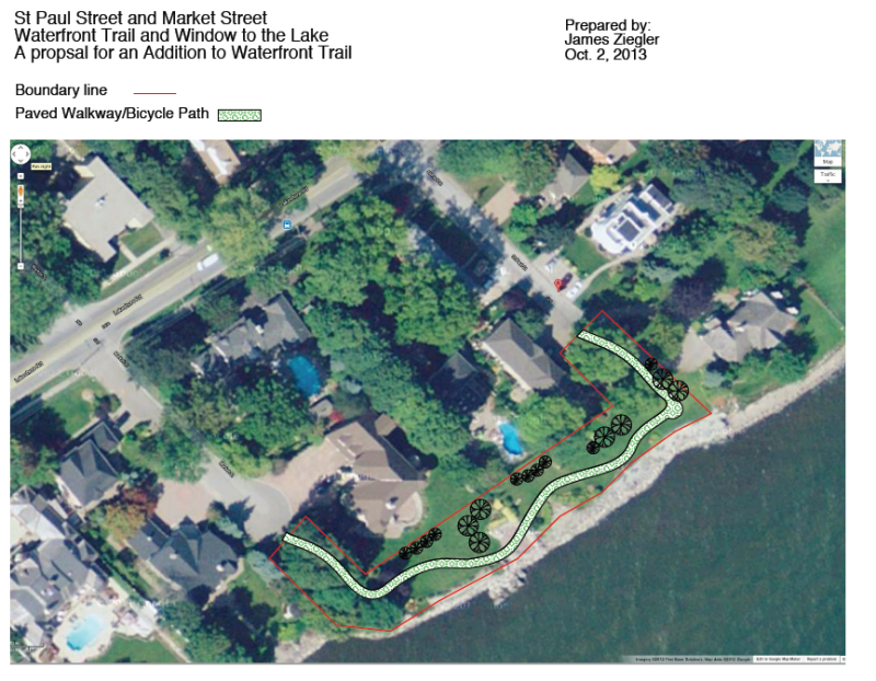
A staff report on what was to be done with property that was referred to as “windows to the lake”.
The Staff report set out three choices: Do nothing, lease the land or sell it.
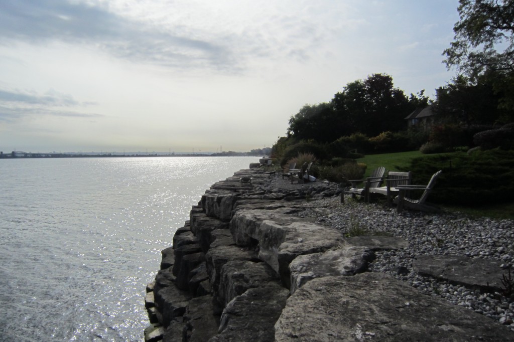
The graphic tells the story. The city owned the land inside the red boundary line. Three property owners had land that abutted the city property. The city sold the land they owned for peanuts. Taylor voted for the sale of that “prize”.
Residents whose property abutted the land saw an opportunity and moved quickly to make an offer. The succeeded in convincing the city to sell them the land and today those property owners have a superb view over the lake and no longer have to put up with the public walking past the edge of their property.
Councillor Taylor – protecting those waterfront views.
During that debate Councillor Taylor grumbled about creating new parkland saying that there was a public park less than a block away. And indeed there was a public park – Port Nelson Park – a small patch of land that has a very good view of the lake.
Taylor said at the time that the public didn’t need anymore parkland in that part of the city.
Taylor was quite right – the “lake is the prize” – then why did he go along with selling lakefront property to private interests in 2015?
We will never know – and that magnificent stretch of land will never be in the hands of the public again.
Has there ever been a citizen petition that Councillor Jack Dennison thought had some merit?
He certainly didn’t have much time for the petition Joanne Arnold presented to city council last night when the decision to approve the bylaw necessary to allow the developer to proceed with the next step as being debated.
Ward 4 Councillor Jack Dennison – not a fan of citizen petitions.
We have yet to see Councillor Dennison ever accept a petition at face value. He consistently challenges the contents of a petition – last night he asked Ms Arnold if she could verify the 144 names that were on the petition – she could not.
“Were they all from Burlington” Dennison asked. Ms Arnold said that some of the people who responded may have been out of the country and responded from wherever they were.
Dennison managed to discredit what the delegator believed was a demonstration of commitment.
He was having none of it.
So much for encouraging people to express their views. It will be sometime before Joanne Arnold chooses to appear before city council
She did what she always does – hammers away at the point she wants to make.
If there is going to be any grass near the now approved 23 storey condominium the city is going to have to lay sod in the Civic Square.
During the lengthy city council meeting Monday evening Ward 2 Councillor Marianne Meed Ward asked each of the delegations what they thought was an appropriate height for the condominium tower that has been proposed for the north east corner of Brant and John Streets – across the street from city hall.
Meed Ward knew what the answers were going to be – there wasn’t a single delegation that was for the 23 storeys that were recommended by the Planning department. The developer had asked for 27 storeys.
Councillor Sharman with his back to the camera debates with Councillor Meed Ward during Strategy Planning sessions. She doesn’t back away from a difference of opinion. Neither does he.
Meed Ward has always been opposed to height in the downtown core. She has a following and represents the views and feelings for the city that many want to retain.
The Mayor sort of shares her view – he just isn’t as good as she is at making her point and sticking to it.
Meed Ward is the only member of Council who consistently asks questions of delegations and staff.
She’s not shy about saying she doesn’t understand something. She sees her role as that of getting the answers she needs and doing the same for her constituents.
Monday evening was a disappointing night for Marianne Meed Ward on several levels – she didn’t make as much as a dent in the position four of the members of council had taken.
She is never going to get a change of mind or a change of heart from Councillors Craven or Sharman.
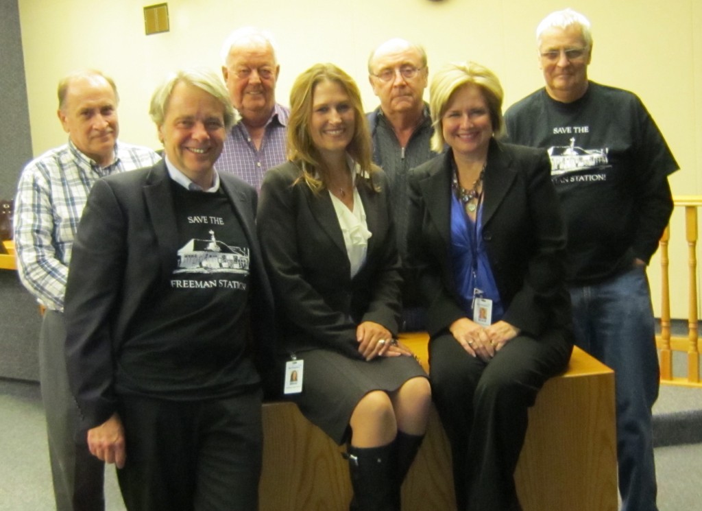
Councillors Meed Ward and Lancaster pose with five members of the Friends of Freeman Station.
She will get a smidgen of acknowledgement from Dennison. She and Councillor Lancaster have never been close – except for the exceptional work the two of them did in saving the Freeman station.
Meed Ward sits beside Councillor Taylor – if anyone was going to side with her philosophically it would have been Taylor – he didn’t budge.
So – what does Meed Ward take away from the decision? She certainly keeps her followers happy – are there enough of them to elect her as Mayor in the October 2018 election?
If Burlington is going to elect Meed Ward as Mayor they want to ensure that they elect people who share some of her views – or this city will face four years of political grid lock.
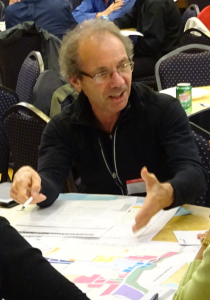
Tom Muir has been delegating to city council as long as the current members have been keeping those council seat warm. John Taylor has served the longest – close to 25 years. Muir is relentless. When he gets his teeth into a bone he just doesn’t let go.
The city is facing a point where it has to decide how it wants to grow and where that growth should take place,
The focus is on Brant Street at this point where a developer has assembled property and taken a proposal for a 27 story condominium to the city’s Planning and Development department where is was recommended but reduced to 23 storey’s. City Council’s Planning and Development committee approved the Staff recommendation on a vote of 5-2. Monday night it goes to city council where it will be approved, revised or nor approved. Here is what Muir thinks of the process so far.
Dear Councilors,
I provided written correspondence on this item to the P&D meeting of Nov. 1, but I was unable to attend that meeting personally.
At this stage in the process, with Committee approval, the conversation here is largely political. With this in mind, a quote credited to Councilor Meed Ward, summarizes accurately and succinctly a question I have been wondering about in terms of how I see this Council operating.
Whose city is it?
“Whose City is it?”
To which I must add from my own experience; Councilors, Who do you represent?
From the evidence that I have been easily able to gather, on this matter, you are, most of you, not representing the citizens that elected you. You appear to have been immunized against the opinions of your constituents.
It is their city, but you do not appear to be hearing them. They are telling you loud and clear that they don’t want these building heights/density, with the associated problems, and they want to know why you are not enforcing the existing laws.
I looked at several recent staff report sections containing public comments. Many of these comments were lengthy and reasoned.
421 Brant St. Neighborhood Meeting: 22 comments – 20 opposed 2 supportive, of which 1 was in the development business.
421 Brant St Statutory Meeting: Of 10 comments, with no exception, the original proposed height of 27 stories was unacceptable – not just a little bit, like 23 is okay, but it was a rejection. For representative examples you can see my P&D correspondence.
421 Brant St. P&D Meeting Nov. 1. There was 1 personal delegation opposed.
There were 3 letters of correspondence, of which 2 were opposed, and 1 offered support for redevelopment but wanted to see compliance with existing OP and bylaws.
So out of 36 public comments received, 33, or 92% are opposed.
And the city says the public is broadly consulted, and uses that claim to defend decisions that are clearly opposed by the public in these consultations.
So who is represented here, and whose city is it really?
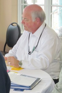
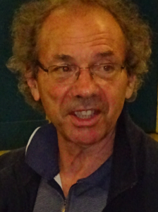
Aldershot resident Tom Muir.
Going further in my findings of public comments on current proposals, let’s consider the Molinaro proposal for 22 (or 24?) stories on Brock St.
Molinaro Brock St. Neighborhood meeting: 9 are opposed, and none spoke in support.
Molinaro Statutory Meeting of Nov. 6/17: There were 4 personal delegations and all were opposed.
There were 13 additional written comments, 12 of which are opposed, and 1 was neither clearly opposed nor supportive, but had several issues and concerns.
So on the Molinaro proposal, there are 26 public expressions of comments, of which 0 speak in support, 1 is equivocal, and 25 are opposed. So basically 100% do not support the proposal.
We can go to the Waterfront, and see the same dominant opposition to the city planners and developer proposals. Or elsewhere, and let’s not forget the ADI Martha St. proposal.
Comments are often lengthy, and basically express the same issues and problems. Consistent concerns are always height, density, no respect for bylaw limits and creeping up proposal by proposal, staff traffic, congestion, parking assertions that are completely at odds with public comment and concern and reality even, and many others you can read.
And adding insult to injury, city and Council can’t wait to hear the residents comment on what they think of the new OP, bylaws, and Mobility Hub ideas before voting to go far beyond anything in those documents for this location.
The draft plan ideas are still just that – not vetted, not discussed or debated, and have no approval and are therefore not policy relevant or legal. Given this, the Committee approval here makes a farce out of the formal consultation to come before it even happens.
To me this erases all doubt that the city, planners, and Council don’t respect or really care to hear what the public thinks of these plans, and wants for what is their city.
Muir delegates and is an active participant at community meetings.
Instead of waiting, as is legitimate and appropriate, decisions are made to go over and above even the 17 story limit proposed, but not approved, for this site in the new Mobility Hub Precinct ideas.
The existing limit is 12, the proposed is 17, but the City Manager and his planners, want 23. And Committee voted 5 to 2 in favor
Is that how Council wants to be seen as representing the people? In a way that drives cynicism?
Some of you say “tall buildings are the future” and “citizens need to get over their concerns”. Well, “tall” buildings in Burlington are anything above 11 stories. So the present permissible of 12 is tall. And certainly the 17 proposed in the Mobility Hub Brant St Precinct is tall. So we are there already.
Consider that the draft 17 is about half way between the existing 12 allowed, and the 23 proposed, perhaps that would be a satisfactory compromise, a hair-splitting solution, to meet there, half-way.
There are other buildings nearby that are tall, so perhaps, in that context, the citizens “could get over their concerns” with this height, if they saw something of their wants being heard.
The people have spoken pretty loud and clear – note the almost 1300 (as of Sunday Nov. 12 at 5:00PM) who signed the petition opposing the proposal.
My ask is this. I read that the Mayor and Councillor Meed Ward, in voting against approval at Committee, suggested that 17 stories was something they could live with, since we seem to be going in that direction in the draft, but not approved plans.
Who do they represent?
So I ask one of them to move, and the other to second, a motion to debate modifying the proposal to 17 stories, and for Council to approve that modification, and send it to staff for appropriate action.
The seven members of city council, sitting as members of the Planning and Development Standing Committee, voted to send the proposal to city council for approval.
A petition has been created for those who want to oppose the Planning and Development committee approved development.
Five of the seven council members recommended that a revised development proposal go to city council where it has to be approved if it is to go forward.
Ward 2 Councillor Marianne Meed Ward and the Mayor opposed the development. Those two are expected to run for the office of Mayor in 2018.
The people who started the petition are looking for 1500 signatures – at this point they have more than 1300. Petition
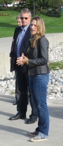
Marianne Meed Ward with the Mayor.
City council meets Monday evening at 6:30 where approval of the Standing Committee will be debated. A number of delegations are registered to speak for five minutes each.
What does a former Mayor say to the current Mayor on issues they disagree on?
Mary Munro – Burlington Mayor 1997 and 1998
Mary Munro, Burlington’s Mayor in 1977 and 1998 has said to Walter Mulkewich Mayor from 1992 to 1997 that she didn’t ever vote for a high rise on Lakeshore Road.
The Bridgewater project was approved during Mulkewich’s term as Mayor.
Now Munro wants our current Mayor to know that she isn’t particularly impressed with what he is doing either.
In a Letter Munro said:
Dear Mayor Goldring:
First of all, I was bemused the City Manager, James Ridge, led off @ what was a Planning Committee discussion of a proposed project. Also bemused by his statement of the desirable merits of the project, leaving no doubts about his support. I wonder about Ridge’s history and his planning experience, let alone the propriety of his intervening @ the outset of discussion — would it be he wanted to forestall the usual agenda, i.e. Planning Dept.’s introduction and explanations of the effects of the project? or to discourage interveners’ arguments or presentations ?
Burlington city manager James Ridge
I believe Ridge’s statements were prejudicial to the aim of the public meeting, i.e to hear from Burlington citizens their views, and to let City Councillors debate the issues without the bias, possibly formed by Ridge’s remarks.
On the merits of the project , as an active and involved Burlington resident since 1959, I somehow “blew it” by long before now, not being aware of the changes to the Official Plan and Zoning By-Laws that allow dense development on Burlington’s “Main Street “. I thought , obviously wrong, we all had a vision of Burlington following the wise moves of our sister communities on the shores of Lake Ontario to stand against density in their downtown and to promote historical and profitable enterprises in their town centres.
It seems to me, B has little likely hood of becoming more than a city of tall towers, not treasuring it’s history and wonderful attractions. More than that, it might be possible to affect change, so late in the game, by looking carefully at candidates in our next City election.
Ask yourself, do we really want reps who say “The future is in tall buildings.” Or one who called “the project fantastic”. Or one who said ” Councillors have to view everything from a high level'”.
This is your city evolved by truly dedicated people — so why not take ownership of your own interests in how we live?
Burlington is in the midst of perhaps the most significant changes it has had to deal with in 20 years. Brant Street is going to look a lot different in ten years; the waterfront will undergo some change. The way people get around the city will change. These are all complex matters. The Gazette will publish a series of articles on what is planned for the Waterfront Hotel site at the foot of Brant Street. This is the first of that series.
A number of years ago during a conversation with a resident about the planned development of a property that was once the Rivera Motel I mentioned the proposed height. The resident said: “I don’t think you have that right, the city would never allow a building that high on the south side of Lakeshore Road in the Downtown core.”
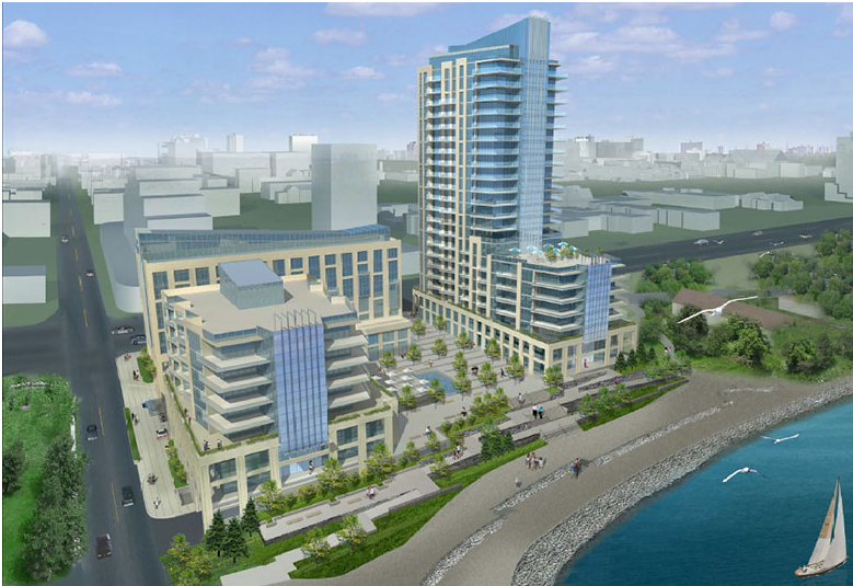
Architectural rendering of the Bridgewater project – view is from the lake. The Waterfront Hotel re-development is to the left (west) of the Bridgewater project.
Little did she know that the city had indeed approved – in 1995 – a structure that was originally going to be 30 storeys but got cut back to 22 storeys. They called it a “Legacy” development in those days.
Today it is known as the Bridgewater project: it rises higher and higher each day as the three structure development begins to change the skyline.
Progress!
Dee Dee Davies, the woman who does a lot of the legwork from the Burlington Waterfront Group sent us a note recently saying there is “Lots happening related to our waterfront.
“This relates to the hotel and private lands at the foot of Brant Street and Lakeshore Road. The city wants to get ahead of the game by determining the resident’s perspective and setting new zoning standards for the updated Official Plan.
The Waterfront Hotel is on the left – the excavated site of the Bridgewater three structure development is on the right.
Following several community workshops, where the city’s consultant appeared to be taking note of the community’s wishes, a preferred concept was presented at the final public workshops on September 14.
That preferred concept “calls for two buildings with various numbers of levels stepped down towards the lake. The west tower would be between 14 – 18 floors and the east tower between 20 – 25 floors, with a 25 metre separation between the towers as public space.
This retains the view corridor along John Street. The buildings would be commercial, residential, hotel, and public service (public washrooms) uses.
Dee Dee Davies went on to say that: “Residents have concerns over this preferred concept on so many fronts. We heard they want only buildings on the east side closest to the Bridgewater complex of less than 20 stories to maximize green space adjacent to Spencer Smith Park. We, along with some of our community partners, are working to develop a concept plan that meets residents needs and present this to city staff before they meet with Council in November.
Dee Dee Davies wants to ensure that the alternative concept put forward by the residents gets serious consideration before it is too late.
On Thursday, Sept. 14, two community workshops took place at the Burlington Performing Arts Centre. At the workshops, results from a survey that asked for input on three concepts for the site were shared and an emerging concept for the site was presented. Table group discussions also took place to obtain further input.
The city has said that “With input from the Sept. 14 meetings as well as information from additional technical studies, the emerging concept will be refined. Draft preferred concepts are expected to be presented to Burlington City Council in November 2017.”
Burlington is a different city today – what city council decided to do in 1995 for the Bridgewater project is not what they would get away with today.
Many are very upset with what they see coming out of the Mobility Hub studies. Some are apoplectic over a 23 storey tower going up across the street from city hall. That decision has been made; it was approved on a 5-2 at a Standing Committee meeting and goes to city Council on November 13th for final approval.
The darker blue area is where the Waterfront re-development is going to built. What the Bridgewater development will look like when completed is on the right.
The work being done by the Waterfront Hotel Planning Study is being led by Todd Evershed and Rosalind Minaji. Their mandate is a study that specifically addresses redevelopment options for the Waterfront Hotel site at 2020 Lakeshore Road. The team has ongoing discussion and dialogue with the planners doing the Mobility Hub planning.
The Waterfront Hotel Planning Study Stakeholder Advisory Committee includes Mayor Rick Goldring, Councillor Marianne Meed-Ward, Darko Vranich owner of the hotel, Kyle Plas, Denise Beard, Charles Priddle, Curt Benson, Lisa De Angelis, Mark Eade, Susan Morrissey and Hashem Mousavi
“The Waterfront Hotel planning study will guide the property owner in the redevelopment of the site. Located next to two of Burlington’s most significant landmarks, Spencer Smith Park and the Brant Street Pier, input from residents is needed to ensure the new development reflects a high quality of urban design that enhances the community’s access to the waterfront and the downtown.”
The Planning Study for the redevelopment of the waterfront site at Lakeshore Road and Brant Street, including the Waterfront Hotel, has been underway for some time. Some of the land south of the Waterfront Hotel is landfill which brought the Conservation Authority into the picture.
The city has known for some time that Darko Vranich owner of the hotel has wanted to increase the density on the property and construct a much larger hotel complex.
The thinking, going back at least ten years, was to re-orient the hotel and have its focus westward along what is now called the Naval Promenade. All kinds of reports and studies were commissioned.
When the owner of the Waterfront hotel let the city know that he wanted to add some height to the land there was an agreement struck that the city would hire people to come up with some design ideas. Three teams of designer/thinkers were to be assembled; two would work with the city – a third would work with the developer. And the developer would pay for all three studies.
That got us to where we are today.
But the natives are restless – they have seen where the developers want to take Brant Street and they fear that the Waterfront hotel property development will become yet another development they have no input on.
The city explains that: “The goal of the Planning Study is to establish the Strategic Framework to guide development on the site by generating and assessing Alternative Redevelopment Explorations, through a public consultation process. The result of the study will be an Official Plan Amendment and Zoning By-law Amendment.
The Brant & Lakeshore Planning Study will establish a Strategic Framework to guide development on the site.
They will develop and assess Optional Redevelopment Concepts along with any formal development applications submitted on behalf of the property owner
The redevelopment of this site must meet the City’s urban design and growth management goals, as well as enhance the adjacent public space and waterfront.
All this resulted in a series of Design Charrette sessions. Several frameworks were put in place to guide the design work – Land Use/ Built Form, Public Realm, and Mobility/Access were set out as the guiding principles.
During the design charrette sessions, led by a member of the Project Team, participants developed 8 Explorations for the study area. Four Explorations were developed in both the afternoon and evening sessions.
Each Exploration was developed within a unique framework with varying Land Use/ Built Form, Public Realm, and Mobility/Access characteristics and with the Vision Statement and Design Principles.
These concepts were posted for comment from the public, community groups, City staff, the Stakeholder Advisory Committee and The Planning Partnership team, and distilled into 4 Explorations based on the input received.
Here is what came out of those design sessions:
The ideas that came out of each Exploration session (there were four of them with afternoon and evening sessions) were displayed as a drawing and then as a visualization of the drawing.
Session 1
Exploration 1 Afternoon session
City visualization Exploration 1 afternoon session
City visualization of the Exploration 2 afternoon session
Exploration 2 evening event
City visualization of Exploration 2 evening session.
Session 2
Exploration 2 – afternoon session
Session 3
Exploration 3 – afternoon session
Exploration 3 – evening session.
Session 4
Exploration 4 evening session
City visualization of exploration 4 evening session
Out of all the work done by the design charettes two distinctly different views are now before the public.
The city planning department Preferred Concept and the design put forward by the community group – Plan B.
This is the plan that a citizen’s group wants. They have moved all the buildings on the east side of the site leaving a much more open area at the foot of Brant Street.
The city planning department has put forward what they are calling the “Emerging Preferred Concept that will have the public access at the foot of John Street and a more limited access at the foot of Brant.
The Draft of the Official Plan will be public on Friday – it runs close to 1000 pages. Those with a major interest in the contents of that document are going to have less than 20 days to respond to it.
Suzanne Mammel, the Halton Hamilton Home Builders Association (HHHBA) Executive Officer explains that Official Plans usually go through at least half a dozen versions. The current document is in its second version.
Burlingtonians complain loudly and frequently about how city council fails to uphold there Official Plan.
There are four Mobility Hub studies taking place. The city wants to get the Downtown Core Mobility Hub approved before the end of the year.
There are the plans for the redevelopment of the Waterfront Hotel property that the city is pushing with their Emerging Preferred Concept. There are citizens who don’t like what they are seeing.
What’s the rush?
The word is that James Ridge the city manager wants as much of this as possible approved by city council before they all move into major election mode.
There are citizens who want to suggest to the city manager that he lighten up and let these issues become election issues.
Back in 1995 city council approved the building of a hi-rise tower on Lakeshore Road – roughly where the Riviera Motel used to be.
It was originally going to be 30 storeys high. Shovels didn’t go into the ground until 2016 by which time the project became a three building project: 22 storey condo, 9 storey hotel and a smaller 7 storey condo.
The Bridgewater development – seen from Lakeshore Road.
Many people were surprised when they learned of the project – they felt the view of the lake was being lost.
There is now another project that threatens to lessen the view of the lake – but this time city council is not going to get as easy a ride as they did in 1995.
There is a group of citizens that want to ensure that the public has a lot to say about this project before it goes too far.
The project is the plans to re-develop the Waterfront Hotel property.
There have been numerous public workshops – registration was less than 50 people most times.
The Planners want to take their favoured concept to a city council Standing committee at the end of the month.
Not so fast is the approach a group known as Plan B who want to slow the decision making process down to allow for far more public input.
They have a petition and a survey they would like people to take part in. Here is their story.
We are circulating links to a City survey and a Petition that we hope you will complete. The Petition takes about 1 minute and the survey maybe 2. This is your chance to influence what direction the City takes with your waterfront.
You may be aware that Burlington City Staff are in the process of developing a master plan for the property on the south side of Lakeshore Road at the foot of Brant Street where the Waterfront Hotel is currently located. This is required prior to the land being redeveloped by its owner.
Staff will be taking two concepts to City Council on November 28, 2017 at 6:30 pm (City Hall). Their first, Option A was developed by a consultant after several meetings with residents. It didn’t capture what residents were asking for, so they developed Option B. Again, it doesn’t capture what citizens are asking for and in some sense could be considered worse, so they are seeking input.
On November 6, three community organizations – Plan B (Burlington Waterfront Hotel Redevelopment), Burlington Waterfront, and Burlington Green met with city staff to discuss an alternative that more closely aligns with what we have heard residents asking for at the public meetings held by City staff.
City staff have a survey on their website asking for input on their two options. Plan B has a petition asking residents to say no to City’s Option A and yes to Citizen Plan B that mitigates some of the issues of the City’s Option B.
Please open the link to the Petition first to view the Plan B proposal prior to completing the City survey so you can reply with an informed perspective.
The Burlington Waterfront organization came out of what was once the Waterfront Advisory Committee that was set up by then Mayor Cam Jackson. The 2010 city council disbanded that committee.
At the time both the Mayor and the then newly elected Ward 2 Councillor Marianne Meed Ward said they were going to set up waterfront committees. The Mayor either lost interest or was beaten to the punch by Meed Ward. She worked with interested people to get them started but never actually ran the committee.
Why didn’t the Mayor and Meed Ward work together? Not a chance – Meed Ward has wanted to be Mayor since the day she decided to run for public office.
Burlington Waterfront is now a group of people who keep their eye on the waterfront and hold informative public meetings. Part of that operation is a group called Plan B – they didn’t like what they sensed was the city was going in and they began to organize.
Ward 2 city Councillor Marianne Meed Ward has always been a strong social media maven. She understands the technology and as a television broadcaster understands the visual medium.
Marianne Meed Ward at a city council meeting.
She is strongly opposed to the approval of a 23 storey structure at the corner of James and Brant street – opposite city hall.
Council gave the building its approval at a Standing Committee a few days ago. That recommendation goes to city Council on the 13th where it gets made the law of the land. If Council votes for the recommendation that came from the Standing Committee (and given that the same people are on the Committee and city council, the expectation is that it will be passed) a bylaw is passed and that’s the end of that story.
Meed Ward has never shied away from controversy. She is described as divisive – as if there is something wrong with that.
The two votes against the project were from the Mayor and Meed Ward. In order for that committee vote to be changed at city council two of the five that voted for it will have to change their minds. It is a defining moment for the city.
Councillors Craven, Taylor, Sharman, Dennison and Lancaster voted for the development.
Meed Ward produced a video – about a minute and a half long. She doesn’t mince her words.
Check it out.
Kelly Childs, owner of Kellys Bake Shop has also done a video. Hers runs for a full 32 minutes.
Well … at least it wasn’t one of those dreaded 4-3 votes that our city council strives to avoid – it was 5-2 to approve the construction of a 23 story tower that will rise at the corner of Brant and James Street opposite city hall.
When completed it will be the tallest building in the city.
The developer had asked for 27 storeys – Planning department came back with 23 and that is where they settled.
“The future is tall buildings” said ward 1 Councillor Rick Craven who added the “citizens need to get over there concerns.”
Councillor Blair Lancaster was very impressed with the staff work – she saw all kinds of best practices. Councillor Dennison liked it – no surprise there.
Councillor Taylor said he will not support waterfront buildings but did support this one because it was not on the waterfront.
Sharman: in favour of project.
Councillor Meed Ward wanted the height limited to 17 storeys – other than the Mayor no one agreed with her.
Meed Ward was not in favour of the development. She said residents want Brant protected from tall buildings. “We must adhere to our official plan and mobility study. There is a disconnect here between staff and the public. It should be a maximum 12 stories.”
Taylor: no tall buildings on the waterfront. Will not support waterfront build but do support this one as it’s not on the waterfront.
The Mayor said the draft mobility hub plan and official plan (albeit old) should be considered and that he thought 17 stories is best. The Mayor said the city needed to protect Brant south of Caroline.
Sharman: in favour of project.
This city council has decided that they can live with what was proposed. Quite what the difference is between a 23 story structure and a 27 storey structure other than the 4 storeys escapes this writer.
The developer now needs to continue the negotiations with the city on the site plan and what there might be in the way of benefits to the city for the additional height and density.
Require the developer to put up a building that would make everyone proud.
The Mayor thought 17 floors was better and decided to vote against the staff recommendation of 23 storeys.
One observer at the meeting pointed out that the Mayor managed to wait until it was clear which direction the vote was going in and then managed to vote against the development after it was a fait accompli. “So much for his support” said the observer who added that “Marianne Meed Ward is alone on this council with regard to the tall building fight! It seems the other Councillors don’t care if it’s not in their ward.”
Lots of talk at last night’s council meeting on developing Brant street.
The thing that horrifies me is that people in support of the 23 story building or against it seem to have no idea why. Developer wants 27 stores, staff want 23 and the mayor wants 17. Average is 22.3 should we go with that? Here is how you should actually decide these things – with math.
The typical Paris apartment building – six floors – “people love them”claims Woodruff.
You never need to build buildings more than 6 floors high – ever. Skip the math if you like – down town Paris, France has a density of 210 per hectare and the buildings are limited to 6 floors – people love that place. The province requires 200 per hectare in down town Burlington. So in practice you can see an actual functional example of the density not needing to be high at all.
However for the skeptics lets go through the math and see why that is. I’m going to round these numbers for readability.
1 Hectare = 107,639 square feet 8% loss for roads/sidewalk 100,000 square feet (107,639/0.92) 50% lot coverage 50,000 square feet (100,000/2) 4/6 floors of living 200,000 square feet (50,000*4) 10% Hallway and amenity loss 180,000 square feet (200,000*0.9) Density of 200 people or jobs per hectare 900 square feet living a person. (180,000/2)
I support large flexible large family apartments so my sizes are 1 bedroom 800 and 2 bedroom 1,200 and 3 bedroom 1,600. This is 6 floor buildings with a floor of commercial at ground floor and a floor of office space and left 50% of the ground open and provided very generous apartment sizes. I still have 5,000 square feet of feet space left over assuming all 1 bed room apartments with 1 person each which is not true in practice. This means lots and lots of space to add back to open space, road/sidewalks or reduce the building to 3 floors along the street which is preferred by pedestrians.
For reference the current density of Burlington is 10 people per hectare possibly 20 per hectare in the non-green belt area. Taking the already build on area to 200 per hectare would mean 2 million people would live here. Even if Copenhagen like ‘alternative’ transportation rates – which there is no evidence at all we could get anywhere close to and have done nothing to produce – road congestion and pollution alone will have reduced this area to a terrible slum long before we get anywhere close to that. The 183 cars proposed in this development alone would stretch out more that 1km in bumper to bumper traffic. That’s half the distance from the lake to Fairview street – from one development. Put that in your pipe and smoke it.
Which gets back to the decision. We can have high buildings – if the local community gets so much for the building – they want it. Seems the only people who want this building are the developers, city staff and councilors that do not represent Ward 2.
So would I approve it – no. It can be limited to 6 floors (yes I know the zoning is 12 at present) or the developers can come back with a better offer that gets people who live down town on board. The principle is: We live here – we decide.
Buildings larger than 6 floors are not required by any provincial planning document. Target density numbers of 200 people per hectare (down town) and 150 (mobility hub) do not require sky scrapers.
People who tell you large buildings are needed to hit density numbers are either mis-informed or spouting gibberish.
Greg Woodruff
Greg Woodruff is an Aldershot resident who has a propensity for numbers and mathematics. He ran as a candidate for Chair of the Region of Halton in the 2014 election. He appears to be setting himself up for a run in the Mayoralty race in 2018. His views are his own and are published as part of a civic debate.
The city of Burlington Planning department has basically wrapped up their work on the draft of the new Official Plan – a red ribbon and a bow and it will be ready for the public. The document is going to get to the public November 10th.
When Suzanne Mammel heard that she at first gulped and then said to herself – really!
Mammel is the Executive Officer of the Hamilton Halton Home Builders Association (HHHBA); the wording of the Official Plan is critical to her membership and vital to the citizens of Burlington.
Suzanne Mammel is the Executive Officer of the Hamilton Halton Home Builder’s Association
Mammel, who at first says the current Official Plan is sadly out of date and that “if we are going to have a new Official Plan then let’s get it right” feels the most significant document the city has is being rushed through the Planning department. Why she asks.
Part of her concern with the rush that is taking place to get the document passed by city Council is that they appear to be trying to get it in place before the next municipal election. Besides being a very important document – it is also a very long document. “I spent weeks reading that document – I’m one of the few people that has read every page of it – I took it to Newfoundland and to Hawaii as I travelled.
“This document sets out policy before all the background work has been done.
“Representing my association, I met with the city planners and took them through a 30 page document that set out our concerns – we didn’t get any answers from the planners – they weren’t ready to respond.”
Mammel said she gets the impression that the planners are not going to listen to anyone.
When an Official Plan is written the document goes through several version – sometime six or seven versions – “the differences get worked out”.
Mammel was very surprised that there was not more in the way of delegations
Big rush to get the new Official Plan approved by Council – why? Can’t the city take the time to get it right the first time?
The Official Plan the public will see later this month will have gone through just two versions. Mammel is of the view that her association will not support the Plan and are prepared to take it to the Ontario Municipal Board if that becomes necessary.
“We want the city Planning department to do their job properly – let’s do it right and take the time to get it right”, said Mammel.
Where is the problem?
Mammel is of the view that the politicians “are positioning themselves for an election that is less than a year away and they want to be able to say that they have put a new Official Plan in place. The problem with that approach is that once the Plan is final the thing has no teeth to fix it.”
The city has rushed forward with the Mobility hub concept – and are pushing hard to get the Downtown Mobility Hub approved so they can put a check mark in the box and tell the public it has been done.
Mammel isn’t at all sure that the public really understands what it taking place.
People in Burlington complain bitterly that city council consistently allows developments that do not conform to the Official Plan. Mammel explains that is happening because the existing plan is so badly out of date. She sees the need for a new Official Plan and wants to ensure that the city gets it right.
Mammel is a graduate of Queen’s University where she studied music – she then studied engineering at Mohawk College and has worked in the construction sector since graduating. She has been with the HHHBA for the past three years.
Ground zero for the Downtown Mobility Hub – no one is all that clear on what the location will look like until the new owners of the site block of properties to the immediate north take their development to city hall.
While the Official Plan is at the top of her list – the Mobility hubs leave her shaking her head. The Downtown Mobility hub was to be a place where people could get public transit to wherever they wanted to go – but the planners seem to want the taller buildings to be further up Brant Street. “Wouldn’t they want the density to be as close as possible to the Downtown Hub?” she asks.
The public struggles to understand the role developers play suggests Mammel – “they build the homes we live in and they have to contend with a regulatory regime that is complex and ever changing.”
“Developers take significant risks – they have to pay for the land assembly – and we are talking about millions of dollars. They have to pay the development charges and for all the studies that have to be provided to justify a development.
“Do they do well financially? Yes they do” says Mammel but there are developers that have lost it all.
The company that is building the Bridgewater today is not the company that started the work. Right now things are very good for developers – but look back to the 80’s and the early 2000’s – it was a very very tough time then.
The block was recently sold – the developer wants to have shovels in the ground within two years – which means Kellys Bake Shoppe is looking for a new home.
The mix of housing available to the public is a challenge for the developers.
The politicians want to see what they call “affordable” housing – by which they don’t mean social housing. The difficulty is that in Burlington property assembling is very expensive. Add to that the cost of the studies that have to be done and you have a very significant investment. $350,000 homes are a thing of the past.
There are developers in this city said Mammel who have projects they want to go forward with now but the city isn’t ready. Those developers can put their efforts into some other piece of property they have assembled but very few of the developers who serve this city are in a position to move from project to project quite that easily.
Suzanne Mammel oversees the interests of the development community for both Hamilton and all of Halton.
Burlington is now attracting new developers who see the opportunities – the Elizabeth Interiors site on Brant Street attracted a number of bidders including National Homes and Reserve Properties – just two examples.
The provincial requirement that Burlington grow and the lack of very little in the way of “greenfield” space means that the growth will be in the high rise sector. The single residence housing that is the Burlington we have now is no longer possible. The cost of land and the demand for housing, explains Mammel is not what it was 10 – 15 years ago. It is a different market requiring different solutions.
While Mammel was not prepared to go on record with any comment on the municipal election that is ten months away she does wonders if the public is beginning to see the significant differences in the direction the known contenders for the office of Mayor want to take?
Building homes and condominiums and apartment buildings is a business – there are risks and for those who take those risks there are rewards. The public tends to see the rewards and shrug off the risks.
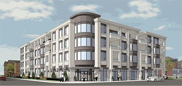
When the project was first brought to the public the project could have been five storeys – the developer decided to go with four storeys.
Will adding two additional storeys make a big difference to the look of the community?
The development was sold out before a sales office was opened. It was going to be a very high end building with every imaginable amenity,
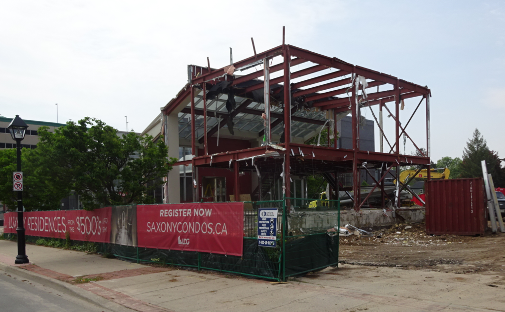
They had to tear down the Melodia restaurant that was never able to make a go of it.
Then the contractors started digging.
The design of the site went through a number of changes. In the very early stage the developer wasn’t able to acquire the restaurant site – when that changed the development changed significantly – it got bigger – now it is going to get higher.
That is when the problems started – there was water where water wasn’t expected and it took a considerable amount of time to figure out what the source was and how to stem the flow.
That problems seems to have been resolved – the cost certainly put a dent in the profitability of the proposed building.
The developer is now asking the city’s Planning department to add two additional storeys to the approved four levels.
Ward 2 Councillor Marianne Meed Ward has said that at this stage she “open to considering the request” for a little more height in that part of the city, which is a block away from the proposed 27 storey structure that Carriage Gate wants to build opposite city hall.
The builders for the Saxony 4-storey condominium at Locust and Elgin have filed an application to permit two additional storeys on the project. The application has not been approved. Staff are reviewing materials submitted by the applicant and will ultimately make a recommendation to city council to approve, refuse or modify the application. Council will ultimately vote on the request.
Meed Ward plans on holding a neighbourhood meeting to seek public input on the request.
Mark Hefferton at mark.hefferton@burlington.ca has been assigned to the file
Burlington’s proposed new Official Plan is scheduled to be released to the public on November 10th.
The document will then be explained to the public at three community meetings and then be presented to the public at a Statutory Public meeting where the public can comment.
The Plan will then go to city council where it will be approved (unanimously?).
At that point it becomes the law of the land – unless someone appeals it to the Ontario Municipal Board.
The proposed new Official Plan contains additions, deletions and modifications to the draft new Official Plan that was released in April 2017.
Feedback received from agencies, stakeholders and the public was considered in undertaking revisions to the draft new Official Plan. Also, the proposed new Official Plan will contain the proposed new Downtown Precinct Plan and associated policies resulting from the Downtown Mobility Hub Area-Specific Planning process.
Following the release of the proposed new Official Plan, the city will hold three open houses and a Statutory Public Meeting.
The Official Plan, when approved will determine just how much of this kind of development can be approved.
Open Houses
The purpose of the Open House sessions is to provide the public with the opportunity to review and discuss the proposed new Official Plan with representatives of the city. There will be no formal presentation given.
Three Open Houses are being held to support the release of the proposed new Official Plan:
Thursday November 16, 2017 6:30 – 8:30 pm Art Gallery of Burlington, Shoreline Room 1333 Lakeshore Road
Monday November 20, 2017 1:00 – 3:00 pm City Hall, Room 247, Level 2 426 Brant Street
Monday November 20, 2017 6:30 – 8:30 pm Haber Community Centre, Community Room 1 – East 3040 Tim Dobbie Drive
The city has created 13 different precincts in the city. Each will have specific Official Plan limitations and zoning attached to guide future development. Sown is the Upper Brant precinct.
There is then a Statutory Public Meeting which provides the public with the opportunity to provide comments to Council on the proposed new Official Plan. A staff report concerning the proposed new Official Plan will be available for public review on November 20th. This report will provide an overview of the key components of the new Official Plan and will include staff responses to feedback received on the draft Official Plan (April 2017).
The proposed new Official Plan will be presented to the Planning and Development Committee at a Statutory Public Meeting on:
Thursday November 30, 2017 1:00 pm and 6:30 pm City Hall, Council Chambers, Level 2 426 Brant Street
It then goes to city Council where it will pass and then sent along to the Regional Council.
The new OP is not a legal document (in force and effect) until the Region approves it.


 By Staff


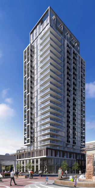 The condominium that is to be built on the corner of Brant and James Street is to rise up to 23 storeys.


 The Draft of the Official Plan will be public on Friday – it runs close to 1000 pages. Those with a major interest in the contents of that document are going to have less than 20 days to respond to it.
 There are the plans for the redevelopment of the Waterfront Hotel property that the city is pushing with their Emerging Preferred Concept. There are citizens who don’t like what they are seeing.
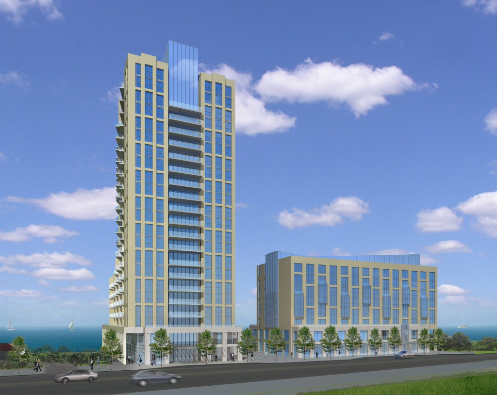
 On November 6, three community organizations – Plan B (Burlington Waterfront Hotel Redevelopment), Burlington Waterfront, and Burlington Green met with city staff to discuss an alternative that more closely aligns with what we have heard residents asking for at the public meetings held by City staff.