By Pepper Parr By Pepper Parr
September 29th, 2021
BURLINGTON, ON
It was during a meeting on that wonderful deck that runs along the north side of Lakeshore Road – across the street from Spencer Smith Park where one can see the ships heading to, or leaving, Hamilton harbour and where, what a long departed friend said, one can enjoy an Adult Libation.
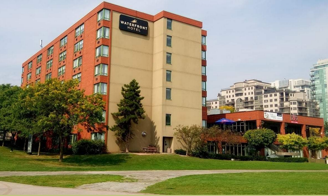
 One of the prime places to just enjoy the city is on the north side of Lakeshore looking out over the lake. Great ideas bubble to the surface while enjoying an Adult Beverage, I was meeting with a couple of friends and talking through possible options and new ideas to keep the Waterfront Hotel site in public hands rather than have a large tower go up.
At the time no one knew that the developer’s plan was for two 30 story plus towers on the site.
Many see the land south of Lakeshore Road as a “public” part of the public realm. Much of it is land that was recovered and made usable with landfill.
The owners of the hotel do have title to some of the land but surely not all the land right up to the edge of the lake.
My friends, who don’t want their names trotted out at this point – at an appropriate time they will be more public. These are men who comment intelligently on public matters.
They wondered aloud if there was not some kind of land swap that could be done.
And that was when a light bulb lit up.
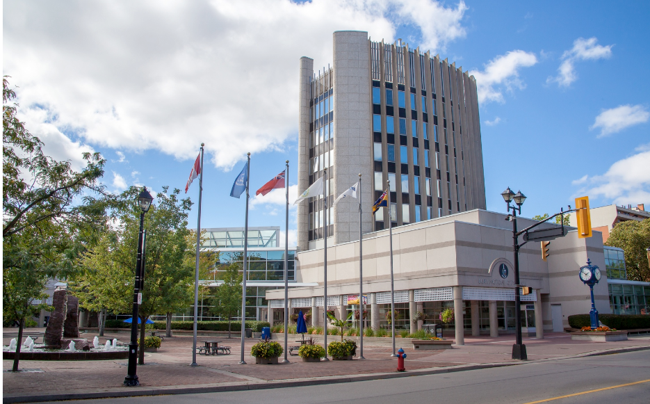
 It doesn’t function all that well as a place to work and the city is going to need a lot more space. City hall as a building is not that functional. It is past its best-before date but, because it is what we have, money is going to be spent on making the best of a bad situation.
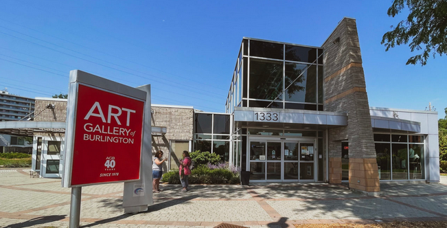
 It is an awkward building – there was no real design – additions kept being added. The entrance was once on the west side. The Art Gallery has never been a truly functional building. It is a collection of additions to a structure that were added on when there was a donor.
So – here is a swap that could be done:
 The owner wants to build and has some impressive designs – that will, if ever built, change the heart and soul of the city. There is a chance to give the developer what they want and to save what is left of Burlington. Exchange the Waterfront Hotel site for the city hall site and the Art Gallery site.
Then design a purpose built building that would house City Hall and the Art Gallery on the Waterfront Hotel site.
Include a band shell and ensure the roof of the structure is environmentally friendly. And ensure that the building is not more than four storeys.
Two for the Art Gallery and two floors for the city.
Hold a charette and commission some design ideas from architects from around the world.
Imagine for a moment: City Hall and the Art Gallery nestled at the base of the slope of the land immediately south of Lakeshore Road leaving a clear view of the Lake. Try the idea on for size the next time you are walking along the promenade and talk it up with your friends.
Parking – that is something that would have to be figured out. The Lotus Street Parking lot is used by city hall staff now – that could continue and there could be some parking beneath the four storey building.
Can’t be done you say? With the right leadership – it certainly can be done.
 Rob MacIsaac, a former Burlington Mayor, took bold steps and changed the city in a way that no one has since his time. Rob MacIsaac, a former Burlington Mayor, did it when he turned the former police station on Locust into the Performing Arts Centre, then had the building that houses a restaurant along with the tourist office on the ground floor and office for the Chamber of Commerce, the BDBA and the Economic Development Corporation on the second floor with five levels of parking above it all.
Then he got really ambitious and got a pier built as well.
So – never say it can’t be done – think about how it can be done and where the leadership is going to come from.
More on this going forward.
Salt with Pepper is the musings, reflections and opinions of the publisher of the Burlington Gazette, an online newspaper that was formed in 2010 and is a member of the National Newsmedia Council.

By Pepper Parr
September 24th, 2021
BURLINGTON, ON
Mayor Marianne Meed Ward once said that fireworks were something she heard about from residents almost as much as parking.
Parking – where do the people driving put their cars when they want to shop, or visit or dine?
Back up a bit and ask – where are all the cars coming from?
Back up a bit more – when a development application is filed with the Planning Department one of the reports that must be included is a traffic study.
Look at any number of those studies and they will all say that the number of cars that might be added to the flow of traffic in the city is “acceptable”, or words along those lines.
The people who write these reports are seen to be professionals who know their craft very well and their evidence is accepted as true.
The traffic reports get an OK from the planners.
And – the OK for that single traffic study might be very valid.
But there is a bigger picture that has to be looked at – and at this point no one is looking or asking the question.
 All the traffic from the underground garage will exist on to Elizabeth, shown on the left. To the left of the development is the site for whatever the Waterfront hotels site ends up looking like for the site The hundreds of cars coming out of the Bridgewater Development will exit the development onto Elizabeth street and then can continue north or go right or left on Lakeshore Road.
The hundreds of cars that are expected to come out of the proposed redevelopment of the Waterfront Hotel site also empty onto Elizabeth Street and then can continue north or go right or left on Lakeshore Road.
While this is, at this point in time, a Ward 2 concern it will become an issue elsewhere when the large developments along Fairview and in the east end of the city come online.
We challenge Councillor Kearns to look for a way to require traffic studies to focus on the impact the single development will have (they are already required to do that) AND to provide a report that sets out the impact their development will have on new developments already approved within a 120 metre radius.
The planners can work out the specifics; the objective is to have information that sheds light on that bigger picture.
It is the bigger picture – everything happening within a specific radius that isn’t being looked at.
The city planners don’t ask – they aren’t required to.
We don’t quite why Heather MacDonald, Chief Planner doesn’t go before council and point out that they are not asked to report on the bigger picture – and ask Council to give them a Staff Direction to do just that.
At some point someone has to get ahead of the problem and ask the bigger question.
If we don’t the phrase in the Official Plan that has Burlington as a “City that Moves” will have to add – moves very very VERY slowly.
To Lisa Kearns and Heather MacDonald – the ball is in your court.
Looking forward to listening to what you put before Council on this one.
Salt with Pepper is the musings, reflections and opinions of the publisher of the Burlington Gazette, an online newspaper that was formed in 2010 and is a member of the National Newsmedia Council.
By Pepper Parr
September 21st, 2021
BURLINGTON, ON
On the evening of September 8th, there was a virtual pre-application presentation given by Bousfields, planners for Burlington 2020 Lakeshore Inc. , which is the company expected to make the application.
It was the first look at what the property owners had in mind for the re-development of the Waterfront Hotel site.
Two things about the images shown below – we were able to show a bit of what the developers have in mind last week.
I think the design is superb.
But I don’t think that design is what the people of Burlington want. It is some distance from the slightly quaint look of the downtown core, which isn’t all that big. It is my belief that there isn’t all that much vibrancy to it. But that’s my personal view.
The decision that gets made about this development is to be made by the people of Burlington.
Unfortunately the people of Burlington didn’t get to see the presentation.
There were just over 100 people participating in the virtual presentation – of which at least a dozen were city staff.
During the Q&A part of the presentation the Gazette asked how we could get a link to the presentation which was recorded.
No one had an answer so on September 11th, I reached out to the Director of Communications Kwab Ako-adjei with the following:
Greetings
I think you will have taken in all of the pre-application virtual meeting on Wednesday.
Quite a show.
As you know it was recorded and the developer didn’t raise any objection on it being made public – what wasn’t clear was –
Thomas Walker (I erred and used the wrong last name – it is Douglas) was asked and didn’t seem to know where it would be located nor did he leave me with the sense that it would actually be put on the city web site.
Would you follow this up for us please.
I address this to you because we intend to follow how the request is handled and want to be on record as having reached out to the head of the Communications department.
Stay well
I later got a reply from Carla Marshal, who is one of the Communications Advisers with the city.
Good morning, Pepper.
Please take a look at this information, which should help to clarify the City’s role in the development application process: Understanding the Development Application Process – City of Burlington
The meeting was led by the developer so the developer owns the recording of the event. The City does not own the recording; the developer does. It is at the sole discretion of the developer, in this case, Burlington 2020 Lakeshore Inc. c/o Bousfields Inc., if and where the recording is posted; it is up to the proponent to decide whether they will post the recording online on their own website: https://bousfields.ca/
Shortly after there was a response from Suzanne Vukosavljevic, who was filling in for Marshall.. She said:
The City posts its own meeting recordings on the City site but in this specific case you are asking about, it was not a City meeting so therefore, the City is not posting the recording.
Your questions have been answered by staff below.
Thanks for your interest.
The city provided the following:
As the communications advisor for Planning, I have worked with staff to provide you with the following information:
From Thomas Douglas, Senior Planner, Community Planning:
Pre-Application Community Meetings are hosted by the proponent of a development, not the City. If/when the proponent proceeds to submit a development application to the City for their proposal, as part of their application they must provide minutes from the Pre-Application Community Meeting, a written summary of public input received at the meeting, and an explanation of how public input has been addressed and reflected in the submitted application.
In cases where a Pre-Application Community Meeting occurs virtually, this may be done using the City’s or the applicant’s teleconferencing program. When the City’s technology is used, staff will record the meeting and provide the recording to the proponent to aid them in documenting meeting minutes and public input received. The City does not post the recording on the City’s website, and it is up to the proponent to decide whether they will post the recording online on their own website.
I will inform the proponent of the 2020 Lakeshore Road development proposal that the Gazette has expressed interest in obtaining a copy of the recording.
I hope this helps!
I didn’t feel my request had been met and responded:
Actually it doesn’t help very much. I then set out more specifically what I was looking for: Carla’s responses are short – set in red.
Does the city have a copy of the event that was recorded? No
Pre-Application Community Meetings are hosted by the proponent of a development, not the City.
If not – does the city intend to obtain a copy?
No
and where will the copy be located on the city web site
The meeting recording will not be located on the City website; it is up to the proponent to decide whether they will post the recording online on their own website –
Further: whose technology was used – re: using the City’s or the applicant’s teleconferencing program. When the City’s technology is used, staff will record the meeting and provide the recording to the proponent to aid them in documenting meeting minutes and public input received.
The applicant has the recording.
Further – who would make the decision to not post the recording, should it become available on the city web site.
it is up to the proponent to decide whether they will post the recording online on their own website
I reached out to the planner Bousfields and asked where we could get a link to the presentation. And waited.
This morning there was a response from the Bousefields planner with a link to the presentation.
And later in the day there was a link from Thomas Douglas with the same link.
That’s a lot of back and forth – but we did get what we were asking for. Why the difficulty is beyond me.
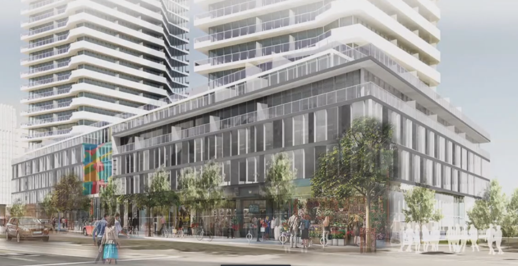
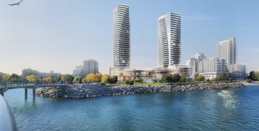
There are two images below. They are of what the building will look like from Lakeshore Road and what it will look like from the Lake.
 A rendering of what the development might look like from Lakeshore Road. Commercial space will exist at grade.
 A rendering of what the site will look like from the Lake. Each tower will sit on a four storey podium and then rise to 30 storeys and 26storeys. In part 2 – there is more in the way of visuals and comment on how the virtual event went and what was learned.
The developer can now submit an application.
When and if they do – they are expected to show how they responded to some of the issues and concerns that were raised.
Bousfields added: Note that the plans are not final and are subject to modifications as we move forward. No formal applications have been submitted at this time, and the public meeting was simply to gauge public interest and explain the proposed intent for the site prior to submission of formal planning applications.
By Pepper Parr
September 11th, 2021
BURLINGTON, ON
Saturday afternoon in the city. Weather was great but the streets in the core were quiet – patios weren’t’ all that populated and that place to be seen on the north side of Lakeshore Road west of Brant was very quiet – you could actually get a seat.
Slide down into Spencer Smith Park and head west and there were line-ups more than a block long – people waiting to get into the Food Truck Festival.
 The lineups to get into the Food Truck Festival were long but they moved very quickly. The line moved quickly – security was keeping a count on the number of people who would be let into the fenced in area. There was an entrance and an exit gate. Inside, all kinds of people – but it wasn’t packed – the objective was to make that six foot distance thing possible.
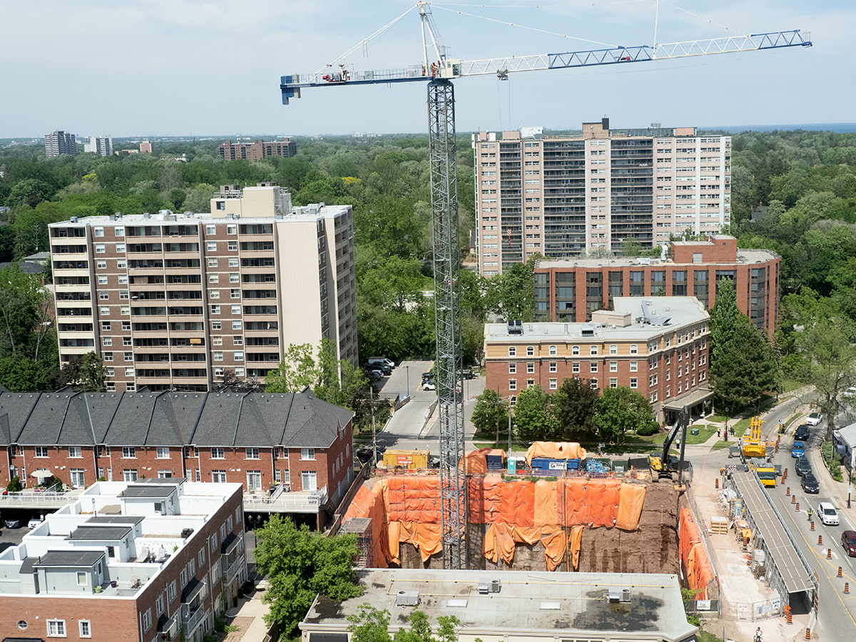
 Great crowds – but no overcrowding. Security ensured that the count was kept at a safe level. While downtown, one wants to check on the construction sites and see how the high rise developments are doing.
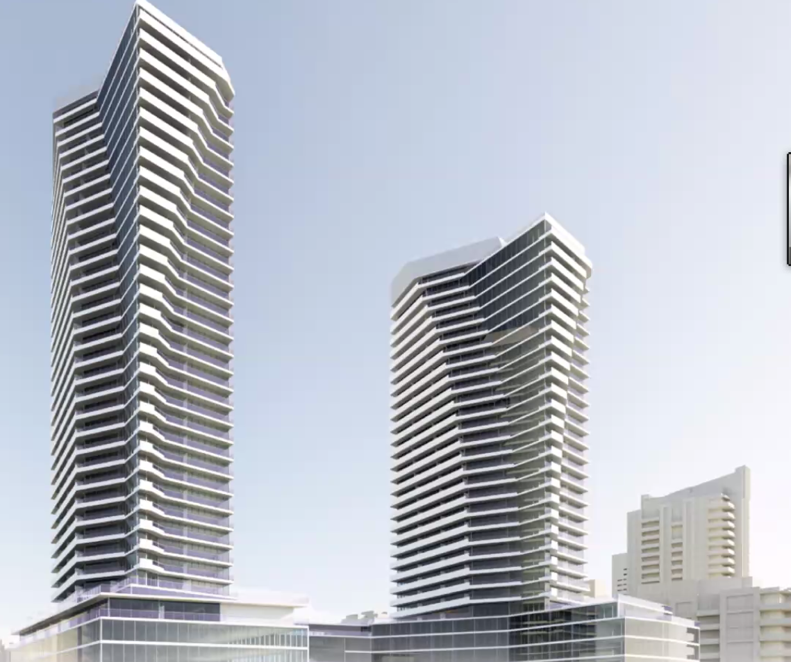
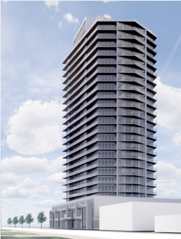
Spent a couple of minutes in front of the Waterfront Hotel site to try and get a sense as to just how close to the sidewalk those 30 and 24 story buildings would be.
The first four levels would be at about where the red arrow is on the photograph. It isn’t clear how far back on the four level podium the towers would be. Lakeshore will never be the same – you won’t be able to see or feel the lake.
If there ever was an iconic location – Spencer Smith Park and the lake are it for Burlington. Done the right way the site could put the city on the map as a destination. Few feel the ideas being floated are the right thing for the city.
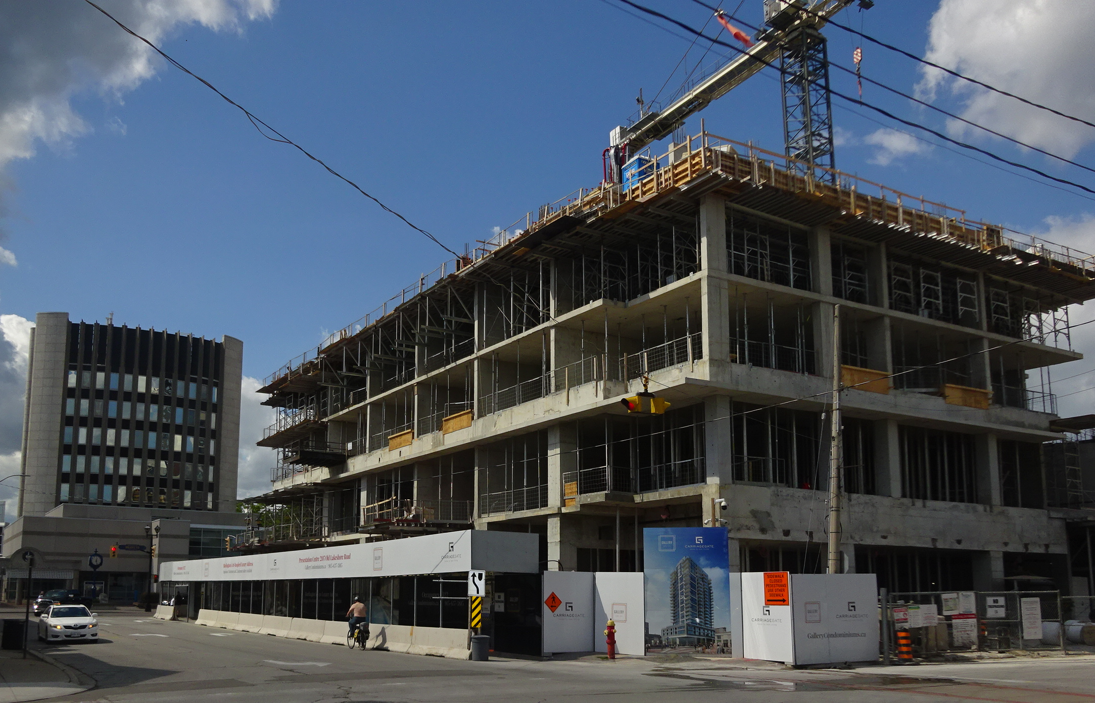
 The red line is where the north wall of the four level podium would be located. Atop the podium would be 26 storeys of housing.  Each tower would sit atop a four level podium. There would be an open space between the two towers that would be at about where John Street is – that opening would give a glimpse of the lake – the property has a steep grade – much like the one at the Bridgewater development a block to the east.  Named The Gallery – the Carriage Gate development is well underway. Four floors in place, underground garage completed – 22 more to go. The 28 storey tower Carnacelli development is growing level by level. Four levels have been poured – 22 to go. Occupancy is said to be sometime in 2022 – at that time citizens will get to know what a high rise building is and what it feels like to have one opposite city hall.
By Pepper Parr
September 9th, 2021
BURLINGTON, ON
Are we ready for this?
They will stand on Lakeshore Road between Brant and Elizabeth Streets. The required Pre-Application meeting took place virtually last night.
There was some expensive talent talking on behalf of the developer who wants to put up two towers: a 30 storey and a 24 story.
The plan is to have 23 studio apartments; 212 single bedroom apartments; 165 1 bedroom + den; 139 2 bedroom and some 3 bedroom. No mention of price.
The panel was asked if there would be any affordable units – really?
There will be a significant bike tails system – but they won’t extend out onto the Pier. – even thought they appear to do so in the report.
 View from the lake. Downtown Burlington will never be the same if this gets approved as it has been presented. During the presentation, given by people representing the developer, David Faletta attempted to convince viewers that the old Urban Growth Centre boundary would apply arguing that the Regional Official Plan affirmed the new boundary but that the Minister had yet to sign off on the Regional decision.
There is a lot more to this story. Stand by.

By Pepper Parr
September 8th, 2021
BURLINGTON, ON
There is a certain amount of satisfaction watching a political leader evolve.
They don’t all manage to grow into real leaders able to listen and to hear.
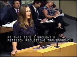
 Marianne Meed Ward was just a citizen when this picture was taken – now she is on the other side of the podium. committee. A number of years ago when Marianne Meed Ward was the council member for ward 2 she came to the realization that people were not aware of what was going on in their communities. A development was being proposed, notices were sent out but to a limited number of people. Meed Ward decided to do something about that and the practice now is to send notices to people within a 120 metre radius of a development.
During a meeting last night when there was a Statutory meeting about the Oval Court development a number of people complained that they had not received the notice of the meeting.
A staff member was asked if notices could be sent to a wider radius – he commented on possible limitations within the Planning Act.
Watching the web cast you could see the Mayor thinking it through – thinking perhaps about how she could arrange to have Statutory meeting notices sent to a larger area.
Watch for something like that in the months ahead.
Later in the same meeting as council members were preparing to wrap it up for the day – it was approaching 10:00 pm, the Mayor took a moment to comment on what things used to be like when development applications were filed..
There would be a Notice of a development application.
There was no such things as a pre-application meeting.
The application would be submitted and then things went quiet – not a word.
Then a Statutory meeting was called. The Planning Act required those meetings.
Council required a report from Staff with a recommendation on the development. They could say yes – it looks good or it is not a good development application and does not represent good planning.
What Meed Ward found amazing at the time was that the Staff Report would be submitted at the same time the Statutory meeting took place.
Whatever comments the public wanted to make during the Statutory meeting was irrelevant – the Staff report had already been written.
That said Meed Ward was the way things were done.
 Councillors had been away from the business of getting things done for six weeks – it was a slow start plagued by technical issues. Delegations to the Statutoy meeting were coming in at a surprising clip – getting the equipment to work was a challenge. Last night there was a Statutory meeting on the Oval Court development. There were some technical problems and it turned out that a lot of people wanted to delegate and found that they were not able to do so.
Again there were technical problems.
The Statutory meeting was very unsatisfactory to both the residents, staff and Council members.
But the meeting had taken place.
Mark Simeoni, Director of Community Planning, told Council that a Statutory meeting was mandated – a meeting must be held and it must be advertised and held in public.
He however added that there was nothing in the Act that said the city was limited to just one Statutory meeting.
 Mayor Marianne Meed Ward: All the ideas, all the things she wanted to do while a member of Council can now be advanced as Mayor. Expect the lawyers who were watching the web cast to be searching through their copies of the Planning Act to see if that was true.
This is a different council, breaking the practices of the past and finding new more effective ways to get things done.
Mayor Meed Ward is far from perfect – she has a lot of growing to do yet – but it is interesting to watch her as she thinks something through, makes a note and comes back to it later on.
By Staff
September 8th, 2021
BURLINGTON, ON
This is not Toronto. This is Burlington and these are the buildings that developers want to construct.
They won’t dot the skyline tomorrow but they are in the works.
 This is the oval Court development that is planned for the east end of the city. To be located on Fairview relatively close to the Fearmans pork processing plant. The 24 story tower in the right is planned for Brant Street south of the Brant Street Plaze – right next to Joe Dogs. How they build this tower and keep Joe Dogs open is more than a challenge.
 The location is very controversial. The area will be razed – Bank of Nova Scotia would go. No one had an answer on what they will do with the width of Brant Street as this point – it is currently a narrow two lane road. The location is very controversial. The area will be razed – Bank of Nova Scotia would go. No one had an answer on what they will do with the width of Brant Street as this point – it is currently a narrow two lane road.
Residents were not opposed to a development – they just didn’t like the idea of a 24 story building. The supermarket to the north will be moved closer to the street and will see a small park with a path along the edge of Rambo Creek.
There will be parking beneath the plaza.
John Street, which is to the east of Brant, will be extended north. Currently John is not classified as a street – it is a lane way.
 This is a Molinaro development planned for the Plains Road area on an odd shaped lot, If approved it will be done in two phases. It will be steps from Mapleview Mall. This is the view from the QEW
By Pepper Parr
August 30th, 2021
BURLINGTON, ON
There is a Battle Royal taking place between two community groups where the focus is on what happens to the quarry on #2 Side Road west of Guelph Line.
The quarry has been there for decades during which time it provided the aggregate needed to build Burlington.
 Nelson Aggregate has gone about as deep as they can go on the current site. The quarry has reached the point where the open pit mine is close to being mined out.
Nelson Quarry has made an application to extend the area they can mine. People in the area are opposed.
Nelson Quarry took a significantly different approach to this second application. In 2012 their application was turned down based on the impact a new mine would have on the Jefferson Salamander.
The quarry people have identified an area that is a breeding ground for the salamander that is to be set aside for just that purpose.
The CORE group are opposed and they have worked diligently to raise finds and fight the good fight.
A second community group – Parks4People want the city to accept the offer of land that will be donated to the city when the extension of the land is also mined out.
THAT eventuality is decades away.
Both Parks4People and CORE are gathering signatures. The Parks4People have 3000 plus signatures – no word on what CORE has but it is understood to be quite close to the Parks 4People number.
The Gazette has done a number of story’s on the CORE group. Their web site is at: https://www.coreburlington.com/
Parks4People put together a presentation that is online at: https://www.parks4halton.com
Their argument is that –
Our parks are already packed
They provide a map that shows park use in Halton on an average weekend. The red shows maximum capacity.
They claim “ our park resources are already stretched thin” adding that with population projections through to the 2040’s “ set to explode” – “where will our children and their children play?”
 If the data is correct – there would appear to be a problem on the horizon. They want to see a plan for how Halton will meet the growing need for green space.
Nelson Aggregates has offered to turn the land over to the city and create a 1,000 acre park.
 Turning a mined out quarry into a park is a great idea – it was done in St Mary’s Ontario and turned out to be very popular. The crunch comes when the details are made public, The Parks4People claim “the mayor has rejected the offer outright. The local councillor has said Halton “doesn’t need a big park.”
Parks4People want Regional council to vote “yes” to parks.
Healthy debate and discussion over different views is a good thing.
The final page of the People4Parks ends with a Call to Action. They want you to click on that box and support their position. Something really interesting happens if you click on the box to show your support. That’s a follow up story.
 That little box is there for you to show your support. Interesting thing happens when you do click. The final decision on this matter will be made by a Joint Tribunal that has a clear process and a time line.
By Pepper Parr
August 25th, 2021
BURLINGTON, ON
It will be as noisy as a virtual meeting can be.
The event takes place on September 8th, from from 6:30-8:30 p.m.
It is billed as a virtual pre-application community meeting hosted by Burlington 2020 Lakeshore Inc. for its proposed mixed-use redevelopment of the Waterfront Hotel.
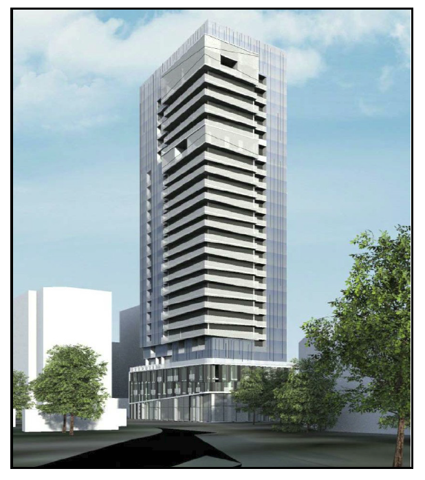
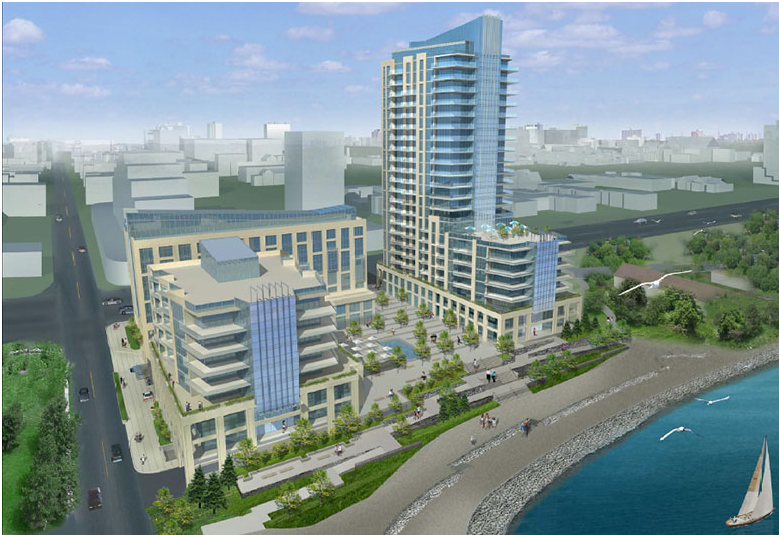
 An architectural rendering of what the owners of the Waterfront Hotel want to build on the site once the existing building is demolished. Burlington 2020 Lakeshore Inc. (the “Owner”) is hosting a virtual pre-application community meeting to discuss a proposal to demolish the existing Waterfront Hotel Burlington building and replace it with a sleek and modern mixed-use development that will accommodate retail and service commercial uses at-grade that will frame the public realm, offices, a banquet facility and restaurants, hotel, and residential apartments.
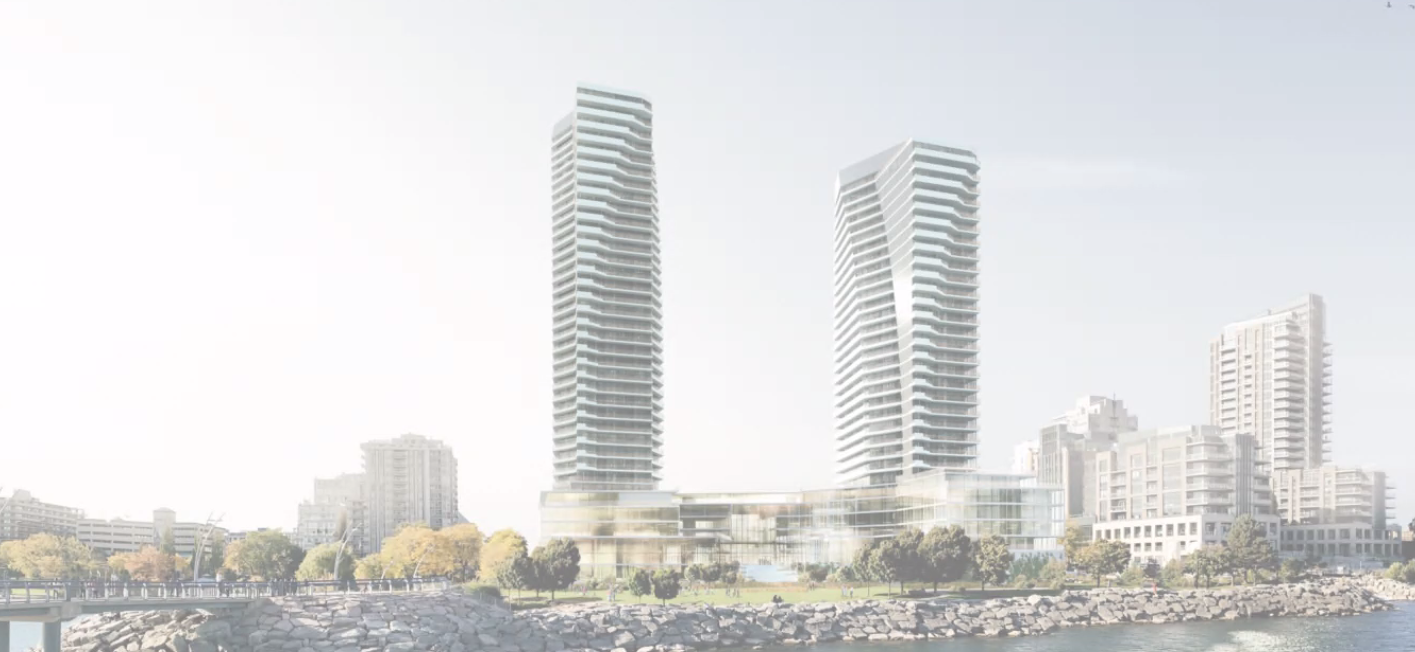
In total, the proposed redevelopment will provide 557 apartments, a 130-room hotel, as well as commercial, office and other accessory uses all within two towers (35- and 30-storeys) inclusive of a 5-storey podium.
The city has not received an application and no decision has been made by the City.
 This eight storey structure will be demolished if the developer can get his proposal for two buildings: a 30 and a 35 story structure can get past the Planning department and the Ontario Land Tribunal. What the public will see is what the owners of the property would like to build on the land.
Public comments may be directed to the applicant on September 8th,
Once a complete application has been submitted the public will be notified, and comments will be received by city staff. This Consultation meeting is the first step in a comprehensive review of the draft proposal. The purpose of the consultation meeting is for the Owner to address key questions and obtain community feedback prior to the submission of any development applications.
During the meeting, the Owner will provide an overview of the proposal and City Staff will provide an overview of the development application review process and how the public can be involved.
There will also be a question and answer component about the various aspects of the proposal and the planning process. Mayor Marianne Meed Ward and Ward 2 Councillor Lisa Kearns will be in attendance to listen to the discussion.
Meeting Agenda:
Introductory comments by Mayor Marianne Meed Ward and Ward 2 Councillor Lisa Kearns;
City Planning Staff Presentation on the Planning Process.
Review of Waterfront Hotel Study;
Owner Presentation on the Development Proposal
Comments and Questions & Answers with the public.
After the event, additional comments, questions, and feedback for the Owner can be directed to the planning consultant, Bousfields Inc., at esugden@bousfields.ca or 905-549-3005, ext. 259.
This development pre-application is separate from and not related to the City’s Waterfront Hotel Study which has established key policy directions for development on this site and is planned to continue later this year.
How to Join the Meeting
Participate On-Line via Zoom:
www.burlington.ca/2020lakeshore OR https://zoom.us/j/93677332408
Webinar ID: 936 7733 2408
Participate by Telephone:
1-647-374-4685 (audio only)
The Gazette will publish background material and just how things got to where they are today.
By Staff
August 18th, 2021
BURLINGTON, ON
The thickening of the downtown population continues.
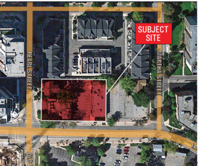
An 11 story structure that will be made up of 130 units with 157 parking spaces and 88 bike racks.
Four levels of underground parking with access of Martha
 Location is 407 Martha – well south of where James and New Streets converge. Location is 407 Martha – well south of where James and New Streets converge.
Mattamy has plans for a large tower just to the north of this proposed development. The Mattamy development is before the Ontario Land Tribunal.
A required Statutory Public meeting is to take place on September 14th at 6:30 pm.
A Staff report will be available the week of the hearing. Staff are reported to be asking for more time to complete the review of the application.
There are creek issues in the immediate area.
There is also a development application for a tower of about the same height on the opposite side of Martha Street.
 Some of the early homes were built along Martha. Some of the early homes were built along Martha.
The character and location of those homes attracted a number of local artists.
The applications propose the redevelopment of the site into an 11-storey residential building consisting of 130 units, resulting in a density of 407 units per hectare. The development proposes a total of 167 vehicle parking spaces within four levels of underground parking and 88 bicycle parking spaces, and vehicular access to the site is proposed to be from Martha Street. The application proposes indoor and outdoor common amenity area at the ground level and through terracing of the building.
By Pepper Parr
August 17th, 2021
BURLINGTON, ON
Dozens of developments are in the hands of the Planning Department and the Ontario Land Tribunal
Those at the Tribunal are related to the Interim Control Bylaw the city imposed two years ago and the 2018 edition of the Official Plan that has been adopted but is not yet in force.
 Waterfront Hotel on the right at the bottom of Brant Street. A development project that has been in various states of review and considerable public debate is the plans to re-develop the Waterfront Hotel site.
The city planners have known for more than a decade that the hotel would be demolished and something quite a bit larger put in its place. The early thinking was to look west along the Promenade and use some of the land that was created with landfill that extended the property out into the lake.
Referred to as the Waterfront Hotel Planning Study it began in March 2017 and was put on hold in June 2018.
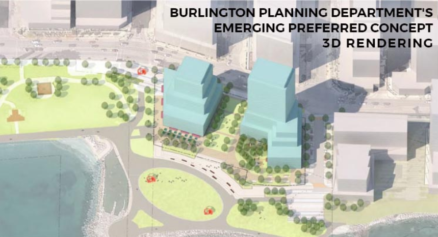
The first view the public got of the thinking going on in the Planning was called the Emerging Preferred Concept. It was not a pretty picture in the minds of a group of downtown people who labelled themselves Plan B.
 It was the two emerging concepts that resulted in the creation of Plan B. could not take place. Their view was that there had to be a line drawn beyond which development could not take place. They felt that the public had to have a clear view of the lake from Brant Street.
 There was a second Emerging Preferred concept that Plan B didn’t think was all that much better The thin red line would allow both Brant and John street to funnel into Spencer Smith Park and still leave for plenty of room for a development that would be zoned mixed use which would allow for some street level retail along the south side of Lakeshore Road.
The buildings would have lower height on the south side and not overwhelm the lake. Also – the elevation is considerable lower as you walk into the park – the height suggested would not impact Lakeshore Road. The last public communication on the status of the study came through Staff Report in May 2020.
“Staff has had preliminary discussions with the representatives for the property owner and are working to create a revised plan to complete the Waterfront Hotel Planning Study in a timely fashion. Unfortunately, the COVID-19 pandemic and other project delays have caused the timing of this work to shift farther into 2020. Staff will provide a report with a proposed revised action plan by Q4 2020.”
The city’s communications people reported that “The role (planner) responsible for leading this study is currently vacant. We are in the hiring process now, and the successful candidate will be charged with re-initiating the work as soon as possible.
The lead consulting firm is The Planning Partnership (TPP).
 This news has the Plan B people ticked, which puts it mildly. With no planner on the file – nothing gets done. This news has the Plan B people ticked, which puts it mildly. With no planner on the file – nothing gets done.
When the Plan B people saw the Emerging Preferred Concept they surveyed the community and came forward with a plan they felt would do justice the the waterfront and the view of the lake from Brant Street.
Their “red line” was crucial.
With Covid providing a good cover for no movement within the Planning Department the Plan B people want a seat at the table.
Burlington they feel has grown to the point where citizens should be in the room when the discussions take place and note just the planners, developers and the developers consultants.
There are precedents for this.
The look of the properties adjacent to Spencer Smith Park are too important to be left in the hands of the commercial interests.
Watch for some healthy public discussion that is open and really transparent.
The city hired The Planning Partnership (TPP) to conduct a number of public sessions – there wasn’t a consensus nor was there much in the way of respect for the public participation. Speakers were shut down, discussion was limited -many felt they were being pushed around by the consultants.
The studies that are being done are paid for by the developer who has input but certainly doesn’t determine the outcome.
By Pepper Parr
August 13th, 2021
BURLINGTON, ON
Burlington and development have for the past five years been in one of those awkward relationships.
The city wants development, the developers want to build – the problem has been what kind of development and where.
It became a menage a trois when the province said that we had to grow – big time. More housing for more people with not much in the way of space for the traditional single family house with a nice back yard that made Burlington what it is today.
Those that live in the southern part of the city didn’t want to see dozens of high rise towers taking over.
The developers wanted their buildings to be in the downtown core where the pricey condos were being built.
The argument got intense from about 2015 to the 2018 election when the issue was the boundary for the Urban Growth Centre.
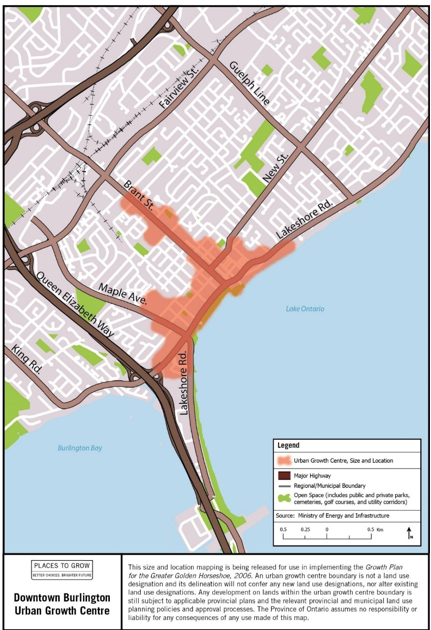
Set out below is the boundary that was in place when the current city council was elected.
 The Urban Growth Boundary that is in the Official Plan that is in force now went through a number of changes. The colours define the different precincts the city is divided into. A precinct is an area that has zoning and development rules unique to that area. Marianne Meed Ward convinced people that she could get hat boundary changed and while the fight isn’t over yet – there are new Urban Growth Centre boundaries in place and once the Official Plan gets completely approved – it is currently in the hands of the Ministry of Housing and Municipal Affairs – where it is expected to be approved – all it has to do is get through the appeals process – there are 40 some odd organizations appealing – it becomes the law of the land.
Meed Ward was adamant from day 1 – the boundary has to be changed.
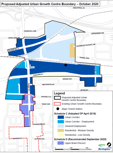
This is what the Urban Growth Centre boundary is going to look like.
Boundaries for the Urban Growth Centre that are part of the approved but not in force Official Plan. Now slide back up and look at what was in place before a new city council set out to make a change
A huge difference – and the credit for much of it belongs to the Mayor. She was thee one who pushed and pushed and did her best not to budge an inch.
It was no small feat.
Meed Ward did not do this alone – what she did was lead the five newcomers to council, who for the most part were on her side when they were first elected, and then supported what she was setting out to do.
The Gazette has a number of differences with how this first term Mayor has handled and portrayed herself; Lord Acton had it right when he said: “Power tends to corrupt, and absolute power corrupts absolutely.” Time will tell if Marianne Meed Ward can catch herself before she falls. None of this should take away from what she did in getting that Urban Growth Boundary moved north,
Salt with Pepper is the musings, reflections and opinions of the publisher of the Burlington Gazette, an online newspaper that was formed in 2010 and is a member of the National Newsmedia Council.
By Staff
August 12th, 2021
BURLINGTON, ON
While the provision of housing, no matter what the price or rental rate, is not part of the mandate the city has – it is a Regional responsibility – Burlington is nevertheless developing a Housing Strategy be housing people is a top priority in the current city council.
 All those white spaces represent new apartment buildings that are in the planning stage. Will people be able to afford to live in them? The objective is to provide current and future residents with more housing options. The Housing Strategy is an opportunity to develop creative and innovative solutions for housing issues in Burlington that will build on and support the Region’s Housing Strategy.
The City is looking for resident feedback to help understand your experience finding a suitable, affordable, safe and accessible housing in Burlington through an online survey HERE
The survey is open now until Sept. 3, 2021. It provides an opportunity to share your experiences, challenges and ideas to enhance understanding of housing in Burlington.
The information collected by this survey will be used to support statistical information, like the Statistics Canada’s Census, to help the City to identify housing issues, gaps and the housing needs of Burlington residents to support the development of a Housing Strategy.
 Some of the data collected in the first survey This is the second survey in the Housing Strategy project. In March 2021, as part of the Housing Strategy Launch, the first Housing Strategy survey was released. This initial survey collected information about housing concerns in Burlington and sought feedback on how stakeholders would like to be engaged throughout the Housing Strategy Project.
The feedback from the first Housing Strategy survey helped us understand people’s interest in housing issues in Burlington. The feedback from the first survey is summarized in the Housing Survey Launch Feedback Report presented to Council in April 2021. This information was used to inform the Housing Strategy project’s Engagement Plan.
Mark Simeoni, Director of Community Planning, Regulation and Mobility is one of the more attuned to the community and its needs than most of the other Directors on the payroll. Burlington poached him from Oakville. The man listens and hears what people say. He will be a strong participant in the development of whatever the city comes up with.
Expect the Mayor to talk about the need for more affordable and attainable housing during the 2022 election campaign – that assumes she will be challenged. Mayor Marianne Meed Ward has made housing both affordable and attainable an issue you can expect her to focus on during the forthcoming election campaign next year. That assumes she is challenged.
“Affordable housing is one of the biggest crises of our time. That’s partly because affordability is no longer linked to income, and supply is taken up by investments. Everyone deserves a safe and affordable place to call home. We will do our part in Burlington using the tools we have. We will also need all hands on- deck, from other levels of government, the private sector, and the non-profit sector.
“No one entity, public or private, can solve the housing crisis alone. Our local Housing Strategy carves out the City’s role to ensure we do our part to the fullest. Our strategy will also identify partners and stakeholders critical to success, ensuring we don’t leave a single stone unturned in helping our current and future residents make one of the most important decisions of their lives and that’s finding a place to live.”
 Mark Simeoni, Director of Community Planning, Regulation and Mobility Mark Simeoni, Director of Community Planning, Regulation and Mobility is one of the more attuned to the community and its needs than most of the other Directors on the payroll. Burlington poached him from Oakville. The man listens and hears what people say. He will be a strong participant in the development of whatever the city comes up with.
By Ryan O’Dowd, Local Journalism Initiative reporter
August 8th, 2021
BURLINGTON, ON
The Member of the Ontario Land Tribunal and the 40+ people and organizations appealing the adopted but not in force Official plan wanted to see time frames and firm commitments from the City of Burlington and Region of Halton in order tom bring the appeals to a conclusion.
 How much of the Burlington that people want to keep will make it through the Ontario Land Tribunal where developers are looking for heights above the 25 storey level. There is considerable doubt that this will happen.
Member is the title of the person presiding over a hearing. On occasion a Member may “seize” a case which means they are the presiding member every time the appeal is heard.
On most occasions the presiding member is whoever is available.
Counsel for the city and an assistant city solicitor balked at having to go through 54 pages of issues that are part of the ongoing appeals. There are two sets of appeals; those appealing the Interim Control Bylaw that was put in place two years ago and the appeals against the new adopted but not yet in force Official Plan.
Two examples of issues are set out below:
 This was an early version of the thinking coming out of the Planning department for the Waterfront Hotel site more than five years ago. A serious loss at the Tribunal might permit something like this. Vrancorp asked:
5. Does the revised Downtown Urban Growth Centre (the “UGC”) boundary identified in the New OP conform to the direction of the provincialGrowth Plan (2019) and the mapping provided by the Province, as required by section 3(5) of the Planning Act?
6. Does the revised Downtown Burlington UGC boundary identified in the New OP conform to the direction of the Halton Region Official Plan (1995) and related mapping?
 The developer offered to keep the Carriage Gate restaurant in place – believing it would be seen as a plus by the public. Another example asked by Core FSC Lakeshore GP Incorporated, the developer who wants to put up a 25 + storey development in the football shaped space between Lakeshore Road and Old Lakeshore Road.
8. Are the policies establishing maximum heights, densities, stepbacks, setbacks, view corridors, transitions, dedication requirements, environmental policies, separation distances for tall buildings, and other performance standards in the Old Lakeshore Precinct:
a. excessively rigid and contrary to the Growth Plan (2019), the Provincial Policy Statement (2020), and fail to give regard to matters of provincial interest?
b. incorporate and impose guidelines, policy and study requirements that have either not received final approval or which represent an overstep of the City’s authority to administer these requirements?
c. have appropriate regard for the amount of parkland that the City can require to be dedicated as set out in the Planning Act, and are these policies ultra vires Section 42 of the Planning Act?
d. given an adequate review or consideration by the City before adoption?
e. Is it appropriate for the City to pass off its study of these policies to applicants?
These are not minor matters – the decision that will eventually be made by the OLT will be determined by how strong the city case is.
So far the city and the Region are looking irresponsible and showing little regard for the timelines and requirement to deliver information in a reasonable amount of time.
The city has to answer the questions and there are hundreds of them.
The city and region were supposed to provide a consolidated list of issues related to the new Official Plan by July 23rd, but they failed to do so. In the Case Management Conference meeting held last Wednesday morning City and Regional staff said it simply was not possible to meet the July 23rd deadline.
The list of consolidated issues is now expected on September 8th and will be discussed at the next case management conference in October, a timeframe the Member deemed relatively expeditious – not everyone saw it that way.
The city had offered to lift portions of the Interim Control Bylaw that had been put in place – that bylaw effectively put a hard stop to any progress on the numerous development applications that had been filed with the city planning department that were within the proposed new Urban Growth centre boundary.
The bylaw froze everything for one year with the option to extend the freeze for an additional year.
The city then took the position that they could not lift the freeze until all the appeals related to that Interim by law were resolved.
At the Wednesday meeting the city said it was prepared to lift the freeze on some of the development projects.
Much of the disagreement was about the delay in bringing the ICBL before the tribunal for appeal. The current interim control by-law “freezes” development around the MTSA (Major Transit Service Area) and within the Urban Growth Centre (UGC).
The old, and currently in force, UGC was focused on the downtown core.
The new UGC is focused on the Burlington GO station area.
The profits on development around the GO station are not as rich as those in the Caroline down to Lakeshore Road part of the city.
The Urban Growth Centre boundary is now much further north than it was when the 2014-18 Council changed the Official Plan. For their part the city’s legal counsel said they would work toward lifting the freeze on areas unaffected by the new zoning by-laws, they expected this to please the developers – this also proved unsatisfactory.
Counsel for West End Home Builders Association (WEHBA) Denise Baker said the appeals process keeps getting “punted down the road.”
Representatives challenged the city’s suggestion of lifting the freeze as vague, lacking substance and a time frame.
Baker was critical of the city failing to schedule a hearing on interim control by-laws.
 The ADI Nautique development got approved when a lawyer managed make a link between a bus terminal and the kind of development that was needed. Denise Baker, some will recall, was counsel for the ADI Development Group when they appealed the decision on the property at Lakeshore and Martha Street where a 26 storey tower is in the process of going up.
Baker was brilliant when she argued that the bus terminal on John Street was an MTSA – which is the designation it had been given even though it is a room that wouldn’t hold 10 people.
The presiding member at the hearing bought the argument and that was enough to approve the ADI development even though they were asking for height on Lakeshore the city had never seen before.
Baker argued on Wednesday that: “At some point, we have a right to have a hearing on the appeals that have now been outstanding for an extended period of time.
She added that “It is absolutely within the tribunal’s jurisdiction to schedule hearings. The “only two months” was part of the ruling on January 14th, and the “only three months” was part of the ruling on April 26th to get to the August 4th date was just not acceptable to Baker who didn’t want to settle for another “only two more months” when it will be dealt with expeditiously.
“ I don’t have a commitment from the city that they will in fact be bringing such a motion” said Baker who added: “They just said they received some instructions to lift the freeze, but no commitment on how they are going to do it or when they’re going to do it.”
The OLT met largely to determine if all the matters the ICBL and the new Official Plan would be heard together. The best that came out of the meeting to push to get the city asnd the Region to get a wiggle on and produce a document that consolidates the 70 pages of concerns and complaints from the development community that is necessary before the actual hearings can begin.
Whenever the hearings do take place it will be quite a zoo if it has to take place virtually.
Burlington has always claimed that it seldom got a fair shake at these tribunal hearings.
The failure to meet deadlines and to move the files forward is not helping.
With Council on a six week vacation there has been no word from the Mayor, who is usually quick to make a comment through at least one of her 17 communication platforms.
One has to wonder as well if there are conversations between the City Manager Tim Commisso and the City Solicitor on just what the problem is.
Ryan O’Dowd is a Sheridan College journalism student who is part of a federally funded Local Journalism Initiative that will have him reporting for the Gazette well into 2022. He is a Burlington native who plays the guitar.
By Pepper Parr
August 7th, 2021
BURLINGTON, ON
There are public hearings taking place at the Ontario Land Tribunal.
Before a full hearing can take place what are known as Case Management Conferences are held that set up the data and sworn statements that will become part of the actual hearing.
At this point in time there are appeals to the ICBL (Interim Control Bylaw) that shut down development in parts of the city for more than two years and the Approved but not in force city Official Plan.
The creation of a new Official Plan is a big deal – the changes the council elected in 2018 put in place were hugely different than the plan the 2014-2018 Council approved.
There are major dollars on the table – opportunities for eye popping profits for the developers and buildings that will change the look, feel and character of the city for decades.
Many people don’t pay all that much attention to these matters – they often don’t understand what is really complex stuff and wonder what difference their voice would make.
Then when they see a 26 storey tower that comes right out to the property line leaving them feel like they are in downtown Toronto they ask: How did this happen?
The picture below is a look at what it at stake.
 The cultural and historical heart of the city has been bought up by developers who want to put up high rise towers reach close close to 30 storeys. Each circle represents a development underway of property on which a development application has been filed.
By Staff
August 4th, 2021
BURLINGTON, ON
The Ontario Land Tribunal held a Case Management Conference this morning that lasted just a little over an hour.
They didn’t get all that much done.
 The City and the Region were required to provide time frames and firm commitments so that the 40+ appeals of the city’s adopted but not in force Official Plan could proceed. The City and the Region were required to provide time frames and firm commitments so that the 40+ appeals of the city’s adopted but not in force Official Plan could proceed.
Representatives from the city and the Region were supposed to provide a consolidated list of issues related to the appeals to the new official plan by July 23rd, they failed to provide this.
 The city’s legal team expressed surprise at the 54 pages of issues received, adding it simply was not possible to meet the deadline. The city’s legal team expressed surprise at the 54 pages of issues received, adding it simply was not possible to meet the deadline.
The list of consolidated issues is now expected to be ready by the 8th of September and will be discussed at the next Case Management Conference in October;, a time-frame the Commissioner hearing the appeals said seemed relatively expeditious- not everyone saw it that way.
Denise Baker, representing the former Hamilton Halton Home Builders Association suggested the city was “punting” this matter down the road.
The city’s legal counsel said they would work toward lifting the Interim Control Bylaw on areas unaffected by the new zoning by-laws, they expected this to content parties – this also proved unsatisfactory.
Representatives challenged the promise to lift the freeze as vague, ambiguous, and without a time frame.
More later today on this breaking story.
By Staff
August 4th, 2021
BURLINGTON, ON
When there is construction work being done within hearing distance from where you sleep – you end up being a very unhappy camper.
Some time ago the city created a policy – Construction and Mobility Management Policy, to address the issue.
 In the past the city has held public meetings and asked the developer of a site to explain to the audience how they will manage the CMMP. Those stand are from the ADI Development Group. The contractors had to submit a plan on how they were going to handle the movement of equipment and construction materials to the site and how they would manage the movement of pedestrian and vehicular traffic around the site.
For the people on Martha Street near Lakeshore a Construction and Mobility Management plan hasn’t made much difference – what has lessened the quality of their lives is the provincial policy that lets workers start at 7 am.
Nothing the city can do about provincial policies – except to maybe write a tart letter.
The city now wants feedback to help refine the policy to address construction impacts on sidewalks, cycling facilities, parking and streets.
This aerial view of the Nautique construction site sets out the problem; the traffic limitations on a very bust road, the sound and construction dust problems. The Construction and Mobility Management Policy, (CMMP) first approved by Council in the fall of 2019 provides guidelines to:
• Minimize impacts to sidewalks, cycling lanes, parking and streets during construction of new developments;
• Provide consistency in the City’s review and approval of proposed developments;
 The Nautique: it was controversial when it was an idea. Some things never change. • Successfully manage multiple developments, potentially in close proximity, while maintaining an active city for residents and businesses; and
• Coordinate private development with planned construction by the City, Halton Region and Utility companies on public roads.
In June 2020, staff proposed an amendment to the original Construction and Mobility Management Policy to establish additional guidelines for the approval and management of low-density residential construction activities, to minimize impacts to public health and safety, amenities, traffic and the environment in the area. Council approved this amendment on June 22, 2020.
Staff is now looking for feedback from residents about how construction has impacted them both before and after the City implemented the CMMP.
How to Participate
Residents and others interested in the Construction and Mobility Management Policy are encouraged to:
1. Visit GetInvolvedBurlington.ca/CMMP to learn more about the policy
2. Take the survey
An online survey will be available until Aug. 27, 2021 at GetInvolvedBurlington.ca/CMMP for residents to share input about how the policy has affected construction around Burlington to date and what the future of the policy might look like.
You might want to use the Gazette search engine to pull up past stories on construction site problems.
By Pepper Parr
July 30th, 2021
BURLINGTON, ON
Rick Craven’s opinion piece was sent to a number of close associates and to other media in the area. The Gazette is not on his media list
Former Ward 1 Councilor Rick Craven put out a small piece earlier today – it may have appeared in the local website he writes for.
Craven takes the position that: “Mayor Marianne Meed Ward’s claim that the Minister of Municipal Affairs and Housing has already approved a boundary change for the Downtown Urban Growth Centre (UGC) may be wrong.
At a press conference on June 15th the Minister did say that he supported the change.
In his article Craven wrote: “The Mayor then publicly claimed victory. “The Province has approved our request to adjust the boundaries of the Urban Growth Centre.”
Not so fast.
“In an oral ruling during an appeal this month, an Ontario Land Tribunal Hearings Officer (OLT) concluded that until the Minister actually signs off on the new boundary, the existing boundary remains in place and would be used to adjudicate the case before him, possibly creating an advantage for the developer.”
Not so fast yourself, Rick.
The Minister of Municipal Affairs and Housing doesn’t just stand up and say – ‘this is the way it is’. He did indeed make a statement on June 15th saying he supported the change in the Urban Growth Boundary.
What he was doing in June was telegraphing what his position was going to be.
Last week the Regional government passed their ROPA 48 (Regional Official Plan Amendment). That document approved the change to the Burlington Urban Growth Boundary and took away that ridiculous MTSA designation given to the John Street bus terminal; a structure that couldn’t hold ten people standing up.
That MTSA (Major Transit Service Area) was let stand during the period of time that Craven was a Councillor – put that burning rubber tire around his neck. It was the existence of the designation that let the ADI Development Group get (what was then) OMB approval for the 26 story Nautique structure on Lakeshore Road.
Craven writes: “The City’s lawyer tried to convince the Hearings Officer otherwise, but without success.
The existing UGC boundary includes areas on both sides of Brant Street to the waterfront. It was set up years ago by the Province to encourage significant intensification.”
 Existing UGC Boundary Craven is totally correct on the province being the people who created the original UGC boundary – where they blew it is in not asking the province to move it.
It was the demand that the UGC boundary be moved that won the election for Meed Ward – something Rick Craven has never been able to come to terms with.
Craven wrote: “Local developers have used this boundary to justify tall building proposals at or near the waterfront including the twenty-nine storey proposal discussed at the Hearing.
The existing UGC boundary includes areas on both sides of Brant Street all the way down to the waterfront.
“Burlington politicians never liked the Province’s UGC boundary. Reacting to downtown opposition to tall buildings, City Council proposed re-drawing the boundary to move it farther north, away from the waterfront. They knew that it would still require Provincial approval.
“It appears now that approval of Council’s change remains somewhere in the wilderness of the Provincial government, contrary to Meed Ward’s public pronouncement.
“Local developers are salivating at what the Hearing Officer’s ruling might mean. Since the City’s proposed boundary is tied to an amendment of the Region’s Official Plan, some believe it may be a long time before it is actually approved.
“The City meanwhile faces a number of appeals and prospective appeals by developers who could potentially benefit from still being located within the Urban Growth Centre. There are outstanding proposals for new buildings as high as thirty-five storeys along the waterfront.
“Developers are also speculating about exactly what the Minister may eventually approve. Will he approve what City Council wants or tweak it, and will his decision be retroactive?
 City’s Proposed New UGC Boundary “In spite of the Hearing Officer’s ruling Meed Ward remains confident.
“We will continue every effort to ensure reasonable growth that accords with community, council and staff vision for the downtown”.
Downtown Councillor Lisa Kearns remains calm amid the uncertainty.
“It would be premature to speculate on the implications of the Tribunal’s oral ruling, or its implications for other downtown proposals, as the details of the reasons reflected in the written decision will need to be considered by the City.”
“The Hearing, during which the ruling occurred, is scheduled to wrap up today. It was about the Carriage Gate Homes proposal for a twenty-nine storey tower at the corner of Pearl Street and Lakeshore.
“In a surprising development the City indicated during the Hearing that it was willing to accept twenty-two storeys, which would be contrary to its own Official Plan and may upset some constituents.
 Site of the Carriage Gate development – asking for 29 storeys – city seems prepared to live with 22. Used to be the site of the Pearl Street Cafe. “If you were hoping for the Mayor and Council to control the growth of new high rises downtown, their position at the OLT to support 22 storeys at Pearl and Lakeshore will be quite a shock”, according to one Facebook comment.
“It may still be months before a final OLT decision on the Carriage Gate matter is announced.
 Former city Councillor Rick Craven “All this may prove particularly uncomfortable for Mayor Meed Ward who has promised for over a decade to “SAVE OUR WATERFRONT” and ran in the 2018 election advocating lower heights in the downtown.”
Craven is out there stirring the pot – exactly what any journalist should do. But he chose to forget the process. What he seems to want is for a judge to make a decision in the middle of the trial – it doesn’t work that way, Rick – and you know that.
Related news story:
Councillor dumps on Meed Ward
By Pepper Parr
July 27th, 2021
BURLINGTON, ON
It is worth going back and reviewing where things were before the current city council was elected and recalling what the issues and objectives were when a study was to be done on how the Waterfront Hotel site was to be developed.
At the time, June 2018, “a clear consensus on direction had not yet been achieved.” An election was about to take place which put a lot of work on hold.
The Planning department wanted some direction from Council and asked for a Staff Direction.
The Gazette reported at the time that:
The Waterfront Hotel planning study will guide the property owner in the redevelopment of this site. Located next to two of Burlington’s most significant landmarks, Spencer Smith Park and the Brant Street Pier, input from residents is needed to ensure the new development reflects a high quality of urban design that enhances the community’s access to the waterfront and the downtown.
The planning staff had asked council to “endorse the key policy directions”. Those directions are set out below:
Extensive engagement was done through three community workshops (a total of six sessions), the Planning and Development Committee held on November 28, 2017, and significant contributions from the Vrancor Group and the Plan B Citizen Group were relied upon to create key policy directions to move forward.
Waterfront concept 1
 Concept 1 from the city planning department: – the buildings are much closer to Lakeshore and the height will disturb a lot of people. The key policy directions for the Waterfront Hotel site are intended to align with the vision statement, accommodate an iconic landmark building, and reinforce the site’s unique location as a major gateway to the waterfront.
Waterfront – Concept 2
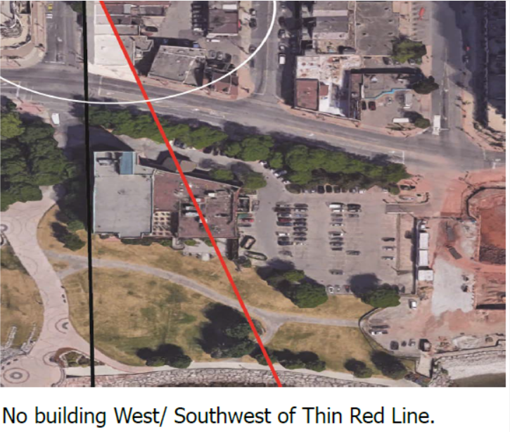
 Concept 2 from the city planning department shifts everything to the right creating a much more open approach to The Pier. The city produced two concepts, neither of which gained all that much traction. A small group who live in the downtown core didn’t like the way the city was handling public participation – they came up with ideas of their own that have shifted some of the thinking being done by the planners. PLAN B, the name of the citizen’s group, took a much different approach suggesting that a red Line starting at the NE corner of Brant and Lakeshore become the demarcation from which there are no building West/ Southwest of the red line.
 The objective of the citizen group thinking was to create a clear generous view from Brant and Lakeshore out to the lake. Don Fletcher, spokesperson for the group, explained the concerns that included:
the adopted OP for downtown and the intensification designations will impact the application and approval of the Waterfront Hotel redevelopment
The participation that Fletcher saw at the Citizen Action Labs sessions caused the Plan B people additional concern about the process and that both City Concepts 1 & 2 seem designed to meet same intensification goals as former Adopted OP – LPAT defensible.
– Tall buildings permitted in Lakeshore Mixed Use Concept 1 at both NE corner w/Brant & NW corner w/Locust transition poorly to neighbouring precincts, but yield higher density
– Podium setback in Lakeshore Mixed Use Concept 2 of only 3m is to compensate for lower density of mid rise building
Fletcher believes that the electorate voted on Oct. 22nd, 2018 for fundamental change to intensification levels and the enforce-ability of the Official Plan.
He concludes that key OP policies should:
– Preserve connections & views to the waterfront
– House mid- to low-rise buildings downtown with taller ones toward Fairview
– Maintain small town character and preserve heritage
– Reflect the community’s vision for the area
Fletcher argued that many attendees at Citizen Action Labs viewed Concepts 1 & 2 as different versions of same over-development and added that a different result from the 2018 Adopted OP demands a different approach.
Citizens’ PLAN B proposes that the city continue to refine recommended Concept (1+2)
Create an alternate What-if Concept to support growth downtown, without Mobility Hub/ MTSA and Urban Growth Center designations and accelerate Land Use Study and publish the report.
Some of what Fletcher wanted has come to pass – the bus terminal is just that – not a Major Transit Station Area (MTSA) and the Urban Growth Centre boundary has been moved north.
Policy Directions
The key policy directions have been organized around the study’s three frameworks and guiding design principles of Land Use and Built Form, Public Realm, and Mobility and Access, as follows:
Land Use and Built Form
1) Create building frontages along Lakeshore Road and Elizabeth Street with building placement that establishes a defining street wall and frames the street zone.
2) Provide active uses at grade along Lakeshore Road and Elizabeth Street.
3) Achieve active and animated edges adjacent to Spencer Smith Park, with a requirement for retail and service commercial uses at grade:
a. Built form next to the south property line shall activate and animate this edge, respect the existing grade, and be scaled to the waterfront trail with higher levels stepping back as necessary.
b. Built form next to the west property line shall activate and animate this edge, respect the existing grade, and be scaled to Spencer Smith Park with higher levels stepping back as necessary.
4) Require a minimum of two uses within buildings and where feasible, encourage three uses.
5) Establish an iconic landmark building on the site subject to the following:
a. A new public, pedestrian space is provided at the foot of Brant Street where public views to the Lake and Pier are enhanced;
b. The iconic landmark building must contain a destination use or function;
c. The iconic landmark building shall enhance the City of Burlington’s image/identity.
6) Require design excellence in all matters of architecture, landscape architecture, sustainable and urban design and require that all public and private development proposals on or adjacent to the site be evaluated/reviewed by the Burlington Urban Design Advisory Panel.
 At one point what was called an “Emerging Concept” was on the table. Wow – that s one whack of development. Public Realm
7) Protect public view corridors to Lake Ontario from Brant and Elizabeth Streets, and, where possible, John Street.
8) Enhance the Brant Street view corridor to frame views to the Brant Street Pier, and require a significant building setback from the west property line.
9) Create new and enhanced publicly accessible green/open space, which would include new north-south pedestrian connections between Lakeshore Road and Spencer Smith Park (mid-block and along the site’s edges).
10) Minimize changes to the existing grade along the southern edge of the site and enhance the interface with Spencer Smith Park.
11) Integrate a public washroom within the future redevelopment; with an entrance that is accessible, highly visible and within close proximity to Spencer Smith Park.
12) Identify opportunities for the placement of public art on, and adjacent to, the site.
13) Vehicle access shall be from Elizabeth Street.
14) Vehicle access from Brant Street will be closed and converted to a pedestrian orientated gateway to the waterfront.
15) All required on-site parking shall be provided underground (parking structures shall not be visible from the public streets and park).
Council is going to be consumed with coming up with a budget that the taxpayers don’t choke on. As they get into 2022 their focus will become more political and their energy will go into getting elected.
Will any attention be paid to getting a decision in place on just what is to happen to the Waterfront Hotel site before Councillors go into re-election mode?
The Ontario Land Tribunal might have something to say on that.
By Pepper Parr
July 26th, 2021
BURLINGTON, ON
Revisions have been made to this story since it was first published.
There appear to be two Facebook based news outlets – both with the name Burlington News.
There also appears to be some significant hearings taking place at what we used to know as Local Planning Act Tribunal now called the OLT – Ontario Land Tribunal.
 The Burlington News logo has a green logo and is the site we have drawn material from. It is popular. WE have not been able to identify the owners of this site. The Burlington News logo has a green logo and is the site we have drawn material from. It is popular. WE have not been able to identify the owners of this site.
 The Burlington News with the red logo has been around a long time – no one knows who is behind that one but there are members of Council who follow what they publish. The Burlington News with the red logo has been around a long time – no one knows who is behind that one but there are members of Council who follow what they publish.
There is yet another web site that was set up by former Mayor Rick Goldring. Former Councillor Craven writes for this site along with former city general manager Kim Phillips.
During an OLT meeting that was focused on the Carnacelli development on the corner of Pearl and Lakeshore Road the argument was over the 29 storeys the developer wanted and the 17 storeys most people believed the city could live with.
The Waterfront Hotel stands at six storeys – plans have been in the works for more than a decade to replace it with a series of structures that would be closer to the water’s edge and more to the east. During that meeting in July, David Bronskill, speaking for the Waterfront Hotel owners is reported to have said the following:
“… our client has concerns with the proposed implementation of this intensification potential. In particular, the ongoing delay in planning for the Property is of serious concern and can no longer be accepted by our client. The Property has not been included within the scope of review related to the new official plan, despite our client having invested approximately two hundred and fifty thousand dollars over five years ago to assist the City in determining the appropriate form of redevelopment for the Property. It would appear that this study is now further delayed with a report on a proposed revise action plan suggested for Q4 2020.”
“During a discussion about height in the downtown, a pending application for the redevelopment of the Waterfront Hotel was revealed. The acknowledgment of a proposed 35 storey development on the Waterfront Hotel site was surprising as there is no information available on the City’s web site, and the lack of transparency regarding the possible future of our waterfront is astounding.
“This proposal will not be a surprise to City staff, the Mayor or Council as they would have known about a pending application as far back as Sept. 2020 when a letter from the landowners representative, David Bronskill advised them of their client’s concerns regarding the City’s delay and their intentions to seek approval of their proposal were made clear.
Bronskill said: “This is unacceptable to our client. We can no longer wait for the City and our client’s intention is to proceed to finalize the study on its own and submit an application to secure approvals for the Property in an expedited fashion.”
“As the city learned with the Interim Control By law, (ICBL) planning and development does not stop and wait for the Mayor and Council. It continues and is considered within the approved policy framework that is in force at the time of the submission of the applications.
” It is not clear if this application has been submitted yet or if it will be in the next few weeks however, there is clearly very little, if any, transparency regarding the status of the Waterfront Hotel redevelopment.”
What would a 35 storey building on the edge of the Lake look like? The Bridgewater condominium is 22 storeys high.
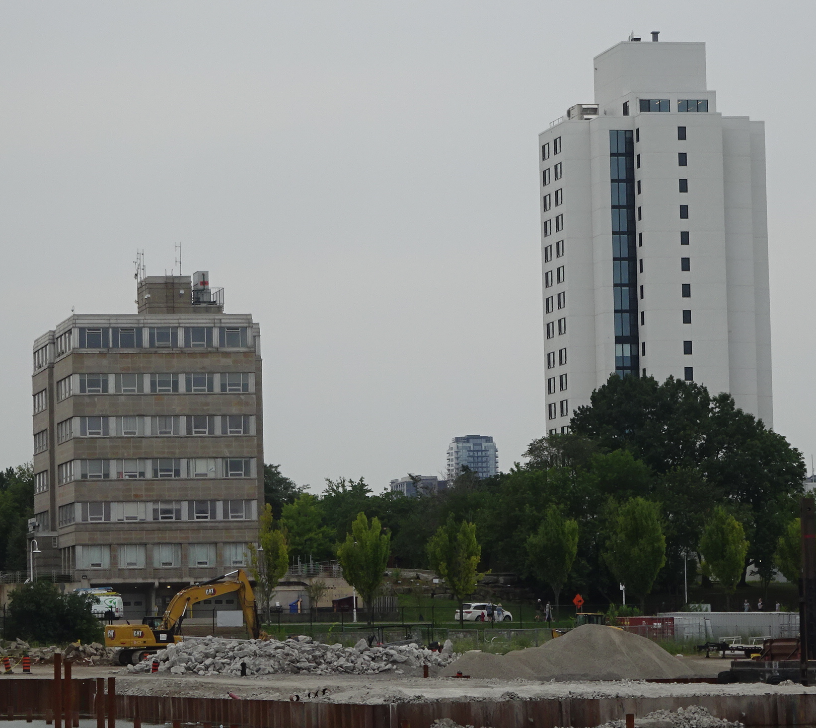
To give you a sense of the height we took a photograph of the Harbour Commission building in Hamilton that is six storeys with a 17 storey building beside it.
 Hamilton Harbour Commission on the left – six storeys; apartment building to the right – 17 storeys. The proposal for the waterfront is 35 storeys -twice the height of the apartment building. What is being talked about is 35 storeys where the current Waterfront Hotel is located.
What the Burlington Local News does not tell is the working arrangement that has been in place for close to a decade, one that had the developer putting up a significant amount of money to pay for a study on how any replacement of the Waterfront would relate to the Naval Promenade.
The lawyers do what they are paid to do at OLT hearings – what is surprising is that the Waterfront Hotel re-development is not before the Planning department yet – there is no word on just where the study is – but legal counsel for the developer has gotten their number on the table.
Related news stories:
Plan B
Is Plan B getting the attention it deserves?
|
|


 By Pepper Parr

 By Pepper Parr


 By Pepper Parr

 By Staff
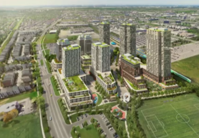
 The location is very controversial. The area will be razed – Bank of Nova Scotia would go. No one had an answer on what they will do with the width of Brant Street as this point – it is currently a narrow two lane road.
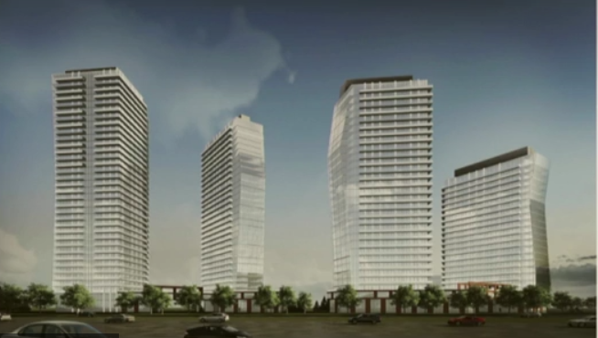
 By Pepper Parr
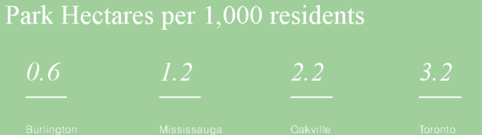
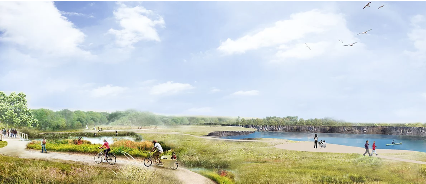
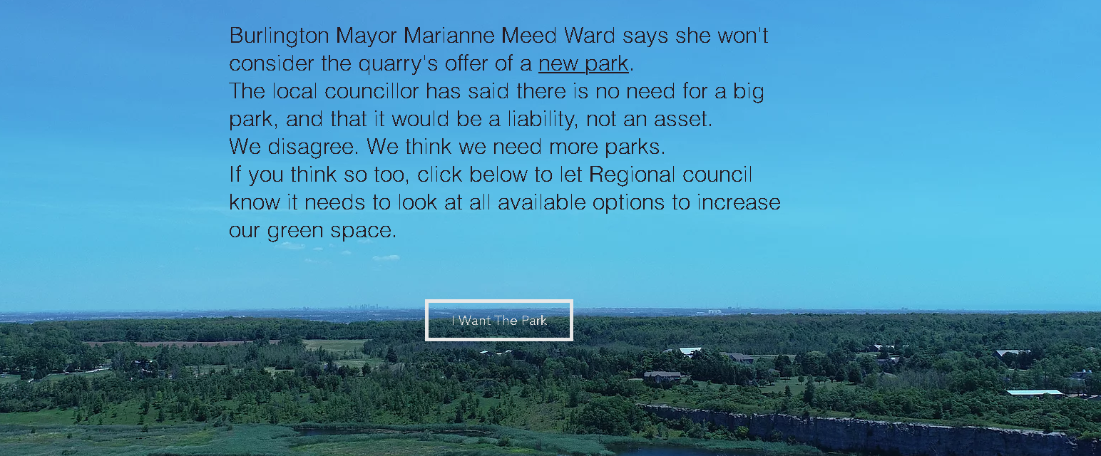
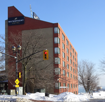
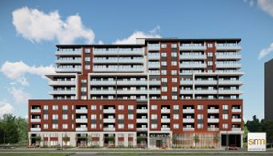 Location is 407 Martha – well south of where James and New Streets converge.
 Some of the early homes were built along Martha.
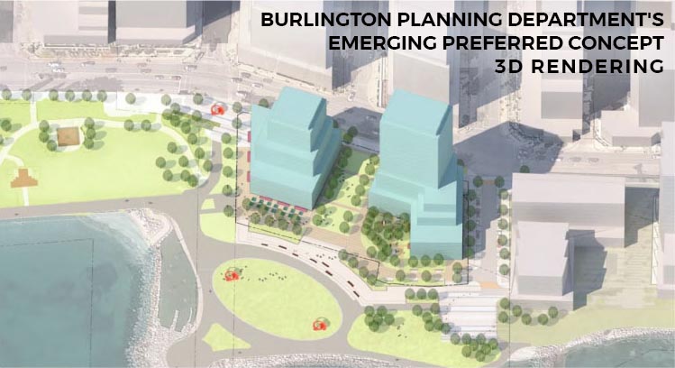
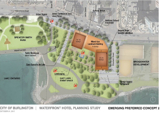
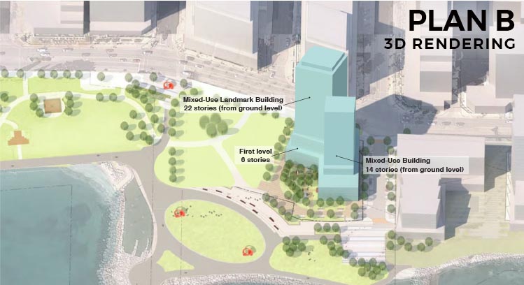
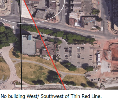 This news has the Plan B people ticked, which puts it mildly. With no planner on the file – nothing gets done.
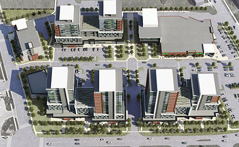
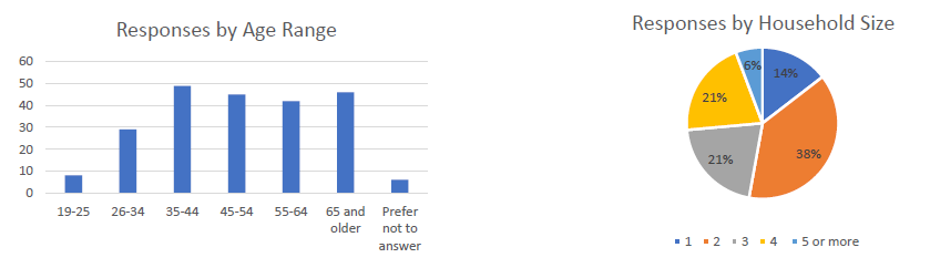
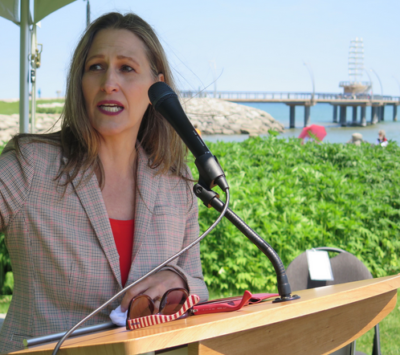
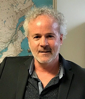
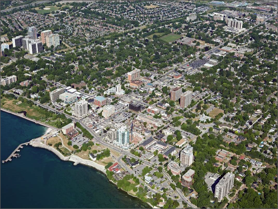


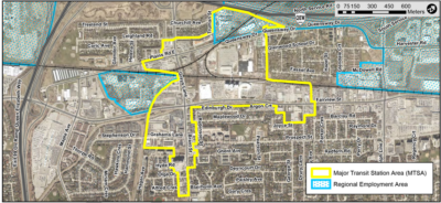

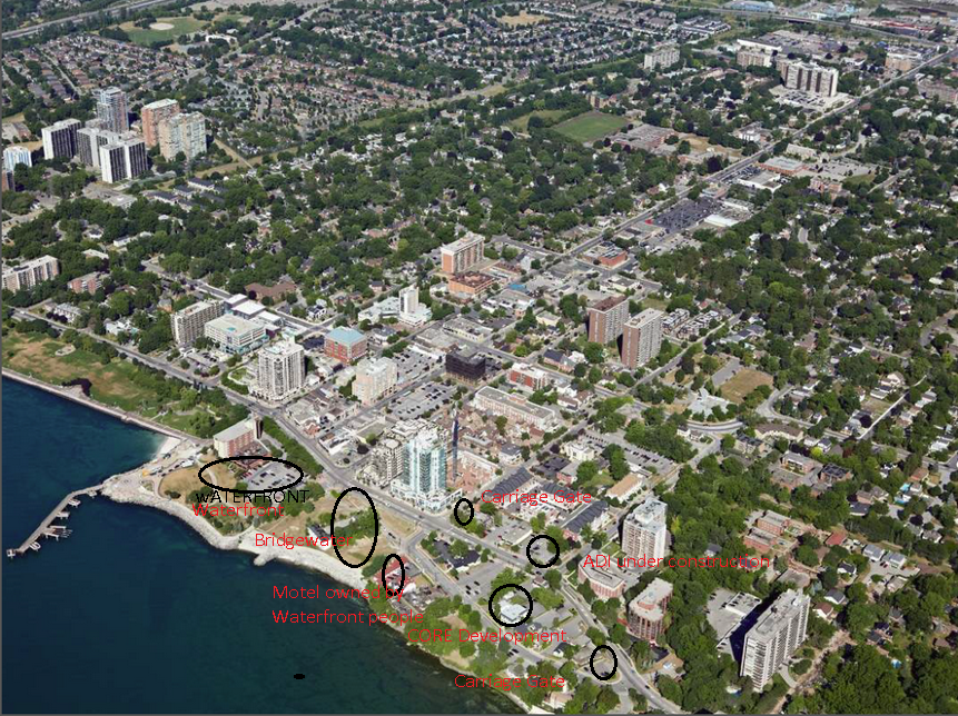
 The City and the Region were required to provide time frames and firm commitments so that the 40+ appeals of the city’s adopted but not in force Official Plan could proceed.
 The city’s legal team expressed surprise at the 54 pages of issues received, adding it simply was not possible to meet the deadline.