 By Staff By Staff
January 26th, 2022
BURLINGTON, ON
Marcello Alaimo, operator of Exquisite Living released some comment on the draft of the Housing Task Force that is expected to release the report and its 58 recommendation at the end of the month.
The task force that was asked to find ways to make Ontario housing more affordable wants to do away with rules that entrench single-family homes as the main option in many residential neighbourhoods, according to a draft report.
The nine-member Housing Affordability Task Force, chaired by Scotiabank CEO Jake Lawrence, wants to “create a more permissive land use, planning, and approvals systems” and throw out rules that stifle change or growth — including ones that protect the “character” of neighbourhoods across the province.
The wide-ranging 31-page draft report, which is making the rounds in municipal planning circles and could look much different when it’s officially released Jan. 31, makes 58 recommendations.
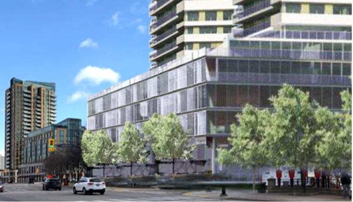
 Zoned commercial, spitting distance to the QEW, minutes from downtown – owner wants to rezone and make it residential. It includes discussions on speeding up approval processes, waiving development charges for infill projects, allowing vacant commercial property owners to transition to residential units, and letting urban boundaries expand “efficiently and effectively.”
It also calls for all municipalities — and building code regulations — not to make it just easier for homeowners to add secondary suites, garden homes, and laneway houses to their properties, but also to increase height, size and density along “all major and minor arterials and transit corridors” in the form of condo and apartment towers.
© Kate Porter/CBC One of the task force’s recommendations is to create rules that would bypass community opposition to adding density in existing neighbourhoods. 4-storey complexes in all neighbourhoods.
But perhaps the most controversial recommendation is the one to virtually do away with so-called exclusionary zoning, which allows only a single-family detached home to be built on a property.
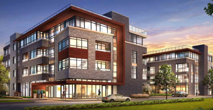 Built by the ADI Group – this four storey could be placed anywhere in the city if the Housing Task Force makes it through the legislature. Instead, the task force recommends that in municipalities with a population of more than 100,000, the province should “allow any type of residential housing up to four storeys and four units on a single residential lot,” subject to urban design guidance that’s yet to be defined.
According to the report, Ontario lags behind many other G7 countries when it comes to the number of dwellings per capita. And housing advocates have long argued that more modest-projects — duplexes, triplexes, tiny homes and townhouses — are needed in established neighbourhoods, especially if the environmental and infrastructure costs of sprawl are to be avoided.
But neighbourhood infill and intensification is often a hard political sell.
“While everyone might agree that we have a housing crisis, that we have a climate emergency, nobody wants to see their neighbourhoods change,” said Coun. Glen Gower, who co-chairs Ottawa’s planning committee. “So that’s really the challenge that we’re dealing with in Ottawa and in Ontario.”
After last week’s housing summit with Ontario’s big city mayors, reporters repeatedly asked Municipal Affairs and Housing Minister Steve Clark if he supported doing away with zoning for single-detached homes, as other jurisdictions like Edmonton and major New Zealand cities have done.
Clark said he’d heard the idea but did not give a direct answer one way or the other.
© CBC Coun. Glen Gower is the co-chair of Ottawa council’s planning committee. He welcomes the discussion about housing affordability in the task force report, but concedes that allowing four-storey, four-unit dwellings in every neighbourhood could be a hard sell.
Reduce construction barriers, approval requirements
Many of the recommendations revolve around making it easier and faster for builders to construct homes.
According to the draft report, not only would a streamlined process allow dwellings to get on the market faster, but reducing approval times would also save developers money which, in theory, could be passed onto residents.
The report cites an Ontario Association of Architects study from 2018 showing that costs for a 100-unit condo building increase by $193,000 for every month the project is delayed.
That’s why, for example, the task force is recommending that any “underutilized or redundant commercial properties” be allowed to be converted to residential units without municipal approvals.
The draft report also calls for quasi-automatic approval for projects up to 10 units that conform to existing official plans and zoning, and goes so far to recommend that municipalities “disallow public consultations” for these applications.
The report speaks to reducing what the task force characterizes as “NIMBY” factors in planning decisions, recommending the province set Ontario-wide standards for specifics like setbacks, shadow rules and front doors, while excluding details like exterior colour and building materials from the approval process.
The task force would even eliminate minimum parking requirements for new projects.
Politicians say more than just supply needed
The report touches on a number of subjects it believes unnecessarily delay the building of new homes, including how plans approved by city councils can be appealed.
It recommends the province restore the right of developers to appeal official plans — a power that was removed by the previous Liberal government.
And in an effort to eliminate what it calls “nuisance” appeals, the task force recommends that the fee a third party — such as a community group — pays to appeal projects to the Ontario Land Tribunal should be increased from the current $400 to $10,000.
© CBC NDP housing critic Jessica Bell supports doing away with exclusionary zoning, but says many more measures, including building more affordable homes, are needed.
That doesn’t sit well with NDP MPP Jessica Bell, the party’s housing critic. who said “My initial take is that any attempt to make the land tribunal even more difficult for residents to access is concerning,” said Bell, adding the NDP is asking stakeholders and community members for feedback.
The tribunal can overturn a municipal council’s “democratically decided law,” she said, “and I would be pretty concerned if it costs $10,000 for a third party to go to the land tribunal and bring up some valid evidence.”
While she was pleased to see the task force address zoning reform to encourage the construction of town homes, duplexes and triplexes in existing neighbourhoods — the so-called “missing middle” between single-family homes and condo towers — Bell said increasing supply is not enough to improve housing for all Ontarians.
 “We need government investment in affordable housing,” she said. “We need better protections for renters, and we need measures to clamp down on speculation in the housing market … We need a more holistic and comprehensive approach than what we are seeing in this draft report right now.” “We need government investment in affordable housing,” she said. “We need better protections for renters, and we need measures to clamp down on speculation in the housing market … We need a more holistic and comprehensive approach than what we are seeing in this draft report right now.”
(While the task force was directed by the province to focus on increasing the housing supply through private builders, it acknowledges in the report that “Ontario’s affordable housing shortfall was raised in almost every conversation” with stakeholders.)
© CBCGreen Party of Ontario Leader Mike Schreiner says he’s opposed to the task force’s recommendation to allow urban boundaries to expand.
Expanding urban boundaries another concern
From his first reading of the report, Ontario Green Party leader Mike Schreiner agreed with the zoning recommendations but said streamlined processes need to be balanced with maintaining public consultations and heritage designations. “One of my concerns with my very quick read of the draft report is that it talks about expanding urban boundaries … and I’m opposed to that,” he told CBC.
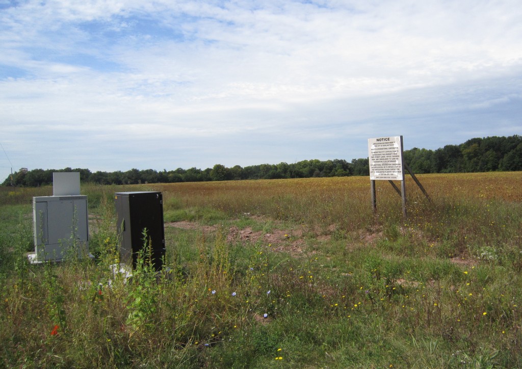
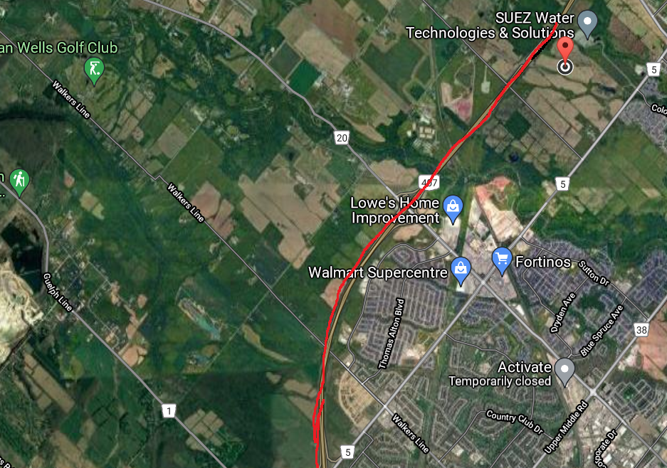 Everything to the left of the red line along Hwy 407 and Dundas are part of the rural boundary. “We simply can’t keep paving over the farmland that feeds us, the wetlands that clean our drinking water [and] protect us from flooding, especially when we already have about 88,000 acres within existing urban boundaries in southern Ontario available for development,” he said.
Schreiner said he’s also “deeply concerned” that the report discusses aligning housing development with the province’s plan for Highway 413 in the GTA. “I simply don’t think we can spend over $10 billion to build a highway that will supercharge climate pollution, supercharge sprawl, making life less affordable for people and paving over 2,000 acres of farmland

 By Pepper Parr By Pepper Parr
January 20th, 2022
BURLINGTON, ON
This report sets out the very awkward situation in which the Planning department finds itself.
If you love your city and you care about what it is going to look like in five years, read on. The report is lengthy.
The city has had a Waterfront Planning Study in the works since 2015. At one point the Planning Department advised that they did not have a planner assigned to the file.
Most people thought progress was being made – turns out everyone was wrong. Nothing (at best very little) was being done.
 The boundary for the Waterfront Study area was clear. The study was paid for by the developer who got tired of waiting and decided to move on with his long term plans While city planners were asleep at the switch the owner of the property wasn’t.
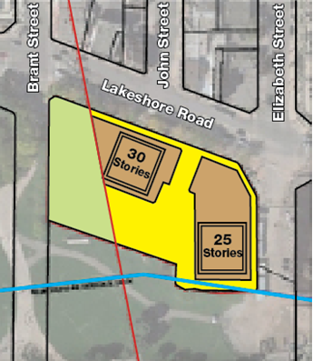
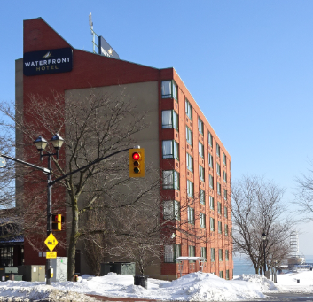
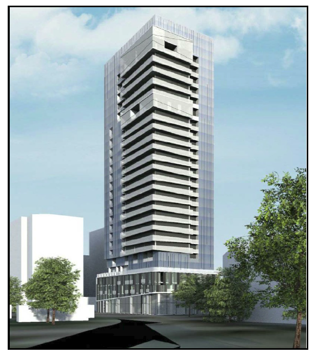
 Darko Vranich, has significant property interests in Hamilton and Burlington which include the adult entertainment site Solid Gold in Aldershot and that small motel immediately east of Bridgewater and doors away from Emma’s Back Porch. The Waterfront Hotel is owned by Darko Vranich, who owns Burlington 2020 Lakeshore Road Inc., the site of the hotel he wants to demolish and put up a two tower development – one at 35 storeys, the other at 30 storeys – both would sit atop a five level podium.
Back in April 28, 2021, the consulting firm, Bousfields (leading the development application team), met with staff in the Planning Department to determine the requirements for a complete development application.
The developer wanted to amend the City’s Official Plan and Zoning By-law to facilitate the owner’s proposal to redevelop the site with a mixed-use development that does not conform to in-effect Official Plan policies or Zoning By-law regulations.
That meeting should have triggered some action on completing the Waterfront Study – apparently it didn’t.
The city provided the developer and their representatives with a preconsultation package (by email – May 5, 2021).
The preconsultation package outlines the following;
Types of applications required (Official Plan Amendment and Zoning By-law Amendment);
Application fees required;
Requirement to hold a Pre-Application Public Consultation Meeting prior to submitting an application;
Required Information for Complete Application.
In accordance with the requirements set out in the preconsultation package, the applicant consulted the Burlington Urban Design (BUD) Panel regarding their proposed development on August 19, 2021. At a meeting less than a week ago the Director of Community Planning, Mark Simeone, was not aware that a meeting with BUD had taken place.
Another example of senior city staff not being fully briefed on everything which was now in play. Staff were fully aware of the scale, size and scope of what the developer had in mind. The public didn’t have a clue until a virtual Pre-Application Consultation Meeting was held via via Zoom September 8, 2021.
Lisa Kearns, the Ward Councillor and Mayor Meed Ward attended and took part – the news was not new to them.
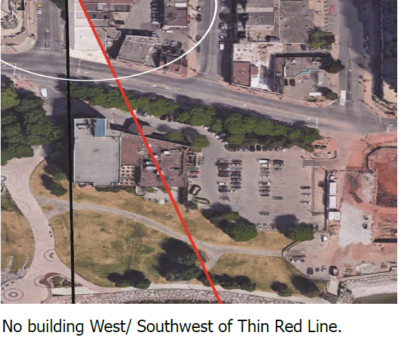 Years before the pre-consultation meeting at which the public got to see what the developer had in mind, a group of citizens believed there was a better way to develop the Waterfront Hotel site and they formed Plan B and created the idea of a thin red line beyond which there would be no development. Years before the pre-consultation meeting at which the public got to see what the developer had in mind, a group of citizens believed there was a better way to develop the Waterfront Hotel site and they formed Plan B and created the idea of a thin red line beyond which there would be no development.
The city, in the meantime, had hired a group to hold public meetings at which different concepts were developed. The Plan B people were never really sure if they were being heard by the city planners. When the graphic below became public it was pretty close to what the Plan B people were prepared to settle for. Was it close enough to the three concepts the city made public? And, by the way, what are the current concepts the city planners have for the site? Nothing anywhere that sets out the city’s position.
You can bet real money that the developer knows what they want – at this point all we have is what they presented last September – and that wasn’t a pretty sight.
 The green area is what Plan B wants left open allowing a clear view to the lake from Brant Street.
On October 22, 2021, City staff received a submission package from the applicant requesting amendments to the City’s Official Plan and Zoning By-law to permit the proposed development at 2020 Lakeshore Road.
On October 26, 2021 the City received the application fees set out in the preconsultation package. City staff confirmed receipt of these materials and fees as of October 26 and initiated a completeness review to determine whether the required information and material, as identified in the preconsultation package, had been provided.
The Planning Department, at first, took the position that the development application was not complete but sometime after the January 13 council meeting at which the development application was deemed incomplete the matter was on the January 18th council meeting as an Urgent Business matter. At that time the application was deemed to be complete.
Sometime on the Friday between the 13th and the 18th meetings new information from someone (either the city planning staff or the consultant for the developer or the city’s outside legal counsel) was provided resulted in the application being deemed complete.
The development application that was deemed incomplete did not have the the following required information:
1. Phase Two Environmental Site Assessment;
2. Park Concept Plan;
3. Angular Plane Study.
Staff notified the applicant that their application had been deemed incomplete.
Subsequently the applicant submitted a request to the Ontario Land Tribunal (OLT) for a motion date to determine if the application was in fact in complete. The OLT never did schedule a date for such a motion to be heard.
On December 17, 2021, the applicant provided the following additional materials to the City in relation to their applications:
1. Phase Two Environmental Site Assessment;
2. Park Concept Plan;
3. Angular Plane Study.
Sometime before January 18th, City staff reviewed the additional materials provided and determined that with the receipt of additional materials described the development application was deemed to be complete December 17, 2021.
The clock was now ticking – starting December 17th, 2021 the city had 120 days to produce a Staff report on the development.
The immediate impact was the loss of about 30 days that could have been used to review the development application to be in a position to complete a review of a very big and a very complex file dumped on a department that was understaffed and had very recently added 15+ planners to staff who had to work in an office environment dictated by the Covid-19 pandemic.
Sometime in February, 2022 the city will hold a required statutory public meeting at Council Committee to consider the development applications. It is expected that the statutory meeting will be virtual, which will crimp the number of delegations made at Council.
Sometime in April, 2022 a Staff recommendation report will be sent to Committee followed by a special Council meeting.
The city has three options:
Approve the application
Approve the application with required changes
Refuse the application setting out the reasons for the refusal
If refused the developer will take the case to the Ontario Land Tribunal
That is not the whole story.
 The night Marianne Meed Ward was elected Mayor of Burlington. When Marianne Meed Ward ran for Mayor in 2018 she told the citizens of Burlington that she wanted the Urban Growth Centre (UGC) to be moved north – to where the Burlington GO station was located.
It took a lot of energy and political guts to take that position but as Mayor, Marianne Meed Ward pushed and pushed and pushed.
And the Minister of Municipal Affairs and Housing eventually agreed and the UGC boundary was moved north with the southern boundary pushed north from Lakeshore Road to about Prospect.
Unfortunately, in the same decision, the Minister grandfathered a number of development sites and said they would fall under the rules of the old UGC – which ran right to the lake. Right where the Waterfront Hotel development is to take place.
The decision didn’t help.
Council passed a motion last week that included an amendment.
Deem, in accordance with sections 22.1, 22(5) and 34(10.2) of the Planning Act, that applications submitted by Burlington 2020 Lakeshore Inc. to amend the Official Plan and Zoning By-law for lands at 2020 Lakeshore Road as made and complete on December 17, 2021, as the required information and materials were provided on that date; and
Direct the Director of Community Planning to notify Burlington 2020 Lakeshore Inc. that the required information and material have been provided for the applications to amend the Official Plan and Zoning By-law for lands at 2020 Lakeshore Road, in accordance with sections 22(6.1) and 34(10.4) of the Planning Act.
The amendment:
Direct the Director of Community Planning to complete the processing of the application to amend the Official Plan and Zoning By-law for lands at 2020 Lakeshore Road within the statutory time frames, and bring forward a recommendation to Council and the Community to provide input and a decision before the statutory review period expires.
So what now?
There is a very senior planner on the file and an all hands on deck attitude is infusing staff – many who are working remotely. Not the best situation to create the sense of team needed to get the very best out of people who have been pushed to the limit for more than 20 months.
To add to the troubled situation, Heather MacDonald, the chief planner as well as an Executive Director with the city, advised the city manager that she was going to retire. This apparently was not a surprise to the city manager.
Members of Council are limited on what they can say about a development that has yet to be put before Council with a Staff recommendation. As a result there hasn’t been as much as a peep from any of them.
 What was Councillor Galbraith opposed to? We do know that Ward 1 Councillor Kelvin Galbraith was not very excited about what took place in those Closed sessions. He didn’t vote for the decision to direct Burlington’s legal counsel to proceed that came out of the Closed session. Because it was a Closed session the public will never know what Galbraith was opposed to.
Way back in 2010 Marianne Meed Ward ran for Council as the ward 2 candidate running on a platform to Save the Waterfront. Burlington may be about to see shovels in the ground by the end of the year putting a dagger in the heart of what Meed Ward set out to do
The Plan B group that wanted the western edge of any development on the hotel site to be limited by what they called a “thin red line.
At one point the Planning department appeared to be onside – no one is sure at this point if the thin red line concept will be applied.
What we do know is that the Planning department is working hard at completing their report that will go to city council and that sometime before it goes to Council there will be a required Statutory meeting at which the developer can tell their story (they are not required to take part) and citizens can delegate on what they don’t like.
It will be quite a meeting.
 Lovely design with great architectural features – but is this what the citizens of the city want in the downtown core?
 Is this the new look of the city skyline?  Is this what the entrance to Spencer Smith Park going to look like?
By Pepper Parr
January 17th, 2022
BURLINGTON, ON
Council has been holding a number of Closed session meetings – all kinds of litigation taking place.
What perplexes a number of people is the way the City Clerk words the motions that are used to make holding a Closed session legal. That is shown in the agenda as: “Confidential update on a litigation matter”; a polite question would be – which litigation matter? – the public has no idea which matter they are talking about.
Providing the address of the property isn’t giving away any secrets and the public at least knows something is taking place.
All the public learns is that: Pursuant to section 239(2)(e) of the Municipal Act, litigation or potential litigation, including matters before administrative tribunals, affecting the municipality or local board.
 This is what you have now ….. Of current concern are the plans for the redevelopment of the Waterfront Hotel site, 2020 Lakeshore Road. This is a very contentious development – quite why the members of city council go along with the city legal Counsel and the Clerk holding their cards so close to their chest, at the same time telling the world that they have the best community engagement record in the country, is what is referred to as talking out of both sides of your mouth. This of course gets done with the blessing of the city manager who appears to like things that way.
The practice is for Council to come out of Closed session and announce a Staff Direction which goes something like this: the Executive Director of Legal Services is directed to do what was agreed upon in the closed session.
Sometimes, rarely, Council will then go into Open session and there will be discussion about what took place in the Closed session.
 …this is what the developer has in mind. They have submitted their development application – city planners say it isn’t complete. As a reporter, I’ve always wondered why the Chairs of the Standing Committees don’t have the courage to stand up and report to the public what took place.
Last week, after lengthy Closed session (it started at 1:00 pm and ended at 6:35 pm) Council reverted to an Open session and for a moment it looked as if they were going to say something publicly about what had taken place. Mayor Meed Ward certainly expected something would be made public and something to the effect that the motion was written to allow something to be said.
Councillor Galbraith and the Committee Clerk didn’t have the same understanding – the Mayor said she would let it go to the Council meeting later in the month.
So we will hear what is happening to the development application for 2020 Lakeshore Road, the Waterfront Hotel Development site, that has been sent to the Planning department, at the next council meeting.
Meanwhile, the clock is ticking on the amount of time the city has to respond to the development application. If they don’t do so within the required time-frame the matter goes to the Ontario Land Tribunal – and we all know what happens there.
.
By Paul Sharman
January 14th, 2022
BURLINGTON, ON
The following response to residents of Burlington who have emailed City Council members regarding the potential increase in urban boundaries in Milton and Halton Hills.
Thank you for your email regarding release of land for housing in the new Region Official Plan leading to 2051. I respect and understand your concerns. I and my Burlington Council colleagues have received hundreds of emails from Halton residents in response to the campaign initiated concerned residents. I am only addressing this subject from the perspective of Burlington in this response.
 Nothing in the Region will be able to open up – maybe next week. Both Region and City members of Council are committed to maintain rural Burlington as it is. There are no plans to allow housing in our rural lands other than as is currently permitted. Release of land is proposed by the Region in Milton and the Halton Hills only, not Burlington.
Official Plans (OP) have extensive analysis and regulations to ensure existing protection remains in place. You will find OP details for Burlington here https://www.burlington.ca/en/services-for-you/Official-Plan.asp
This is a challenging issue for us all. There are a number of factors that have to be considered:
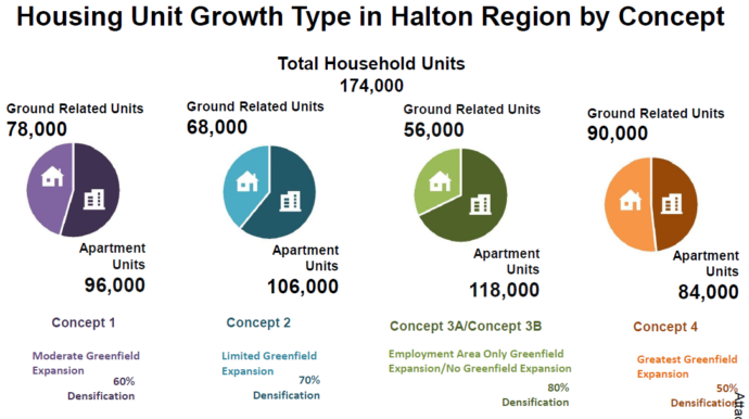
The first is that the Region of Halton is obliged to craft a plan that satisfies the province’s 1.1m population requirement by 2051.
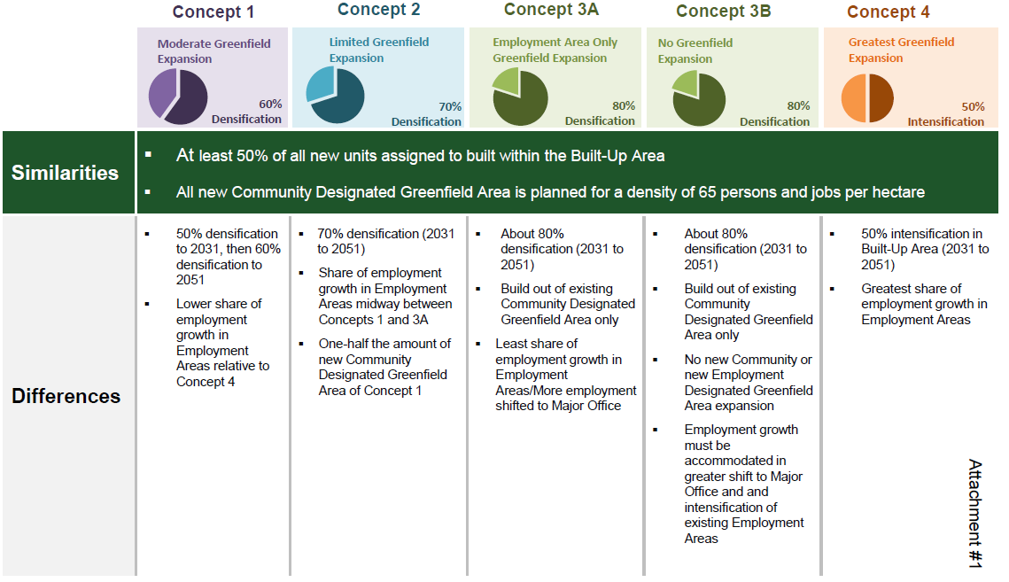
The second is that the Region must provide substantiation that the plan will satisfy market demand. Scenarios 3a and 3b, which have been considered, provided for significantly greater % of apartment units and very few ground oriented homes than other scenarios and could not satisfy the market test. Indeed, the recent preferred scenario is barely representative of anticipated demand. Keep in mind that Canadian dream is to live in a house with a garage and a yard, as you will understand. The preferred solution is a compromise.
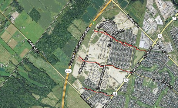 Hwy 407 and Dundas Street are the northern boundaries for development in Burlington. The Alton community would never have come into being were it not for the building of the 407 highway. That decision opened up land that was part of rural Burlington. Alton Village is bounded by the 407, Walkers Line on the west and Appleby Line on the east with Dundas making up the southern boundary. The third is that because Burlington is essentially built out, we receive all residual population growth that cannot be accommodated in Oakville, Milton and Halton Hills in what ever scenario is selected. In scenario 3a and 3b, that would mean in excess of 80,000 new residents moving into Burlington by 2051, like it or not.
Because Burlington is essentially already built out, under scenario 3b, Burlington will have no other choice but to to accommodate about 90% of new residents in 200/300 mid to high rise apartment buildings.
That would happen in 5 strategic growth areas of Appleby GO, Burlington GO, Aldershot GO, Up Town (Upper Middle Road and Appleby Line) and Downtown Burlington. We do not know what the distribution of those apartment buildings will be yet, but it certainly means significant densification of all five locations. It creates a tenuous outlook for all five, including downtown, by the standards of most Burlington residents.
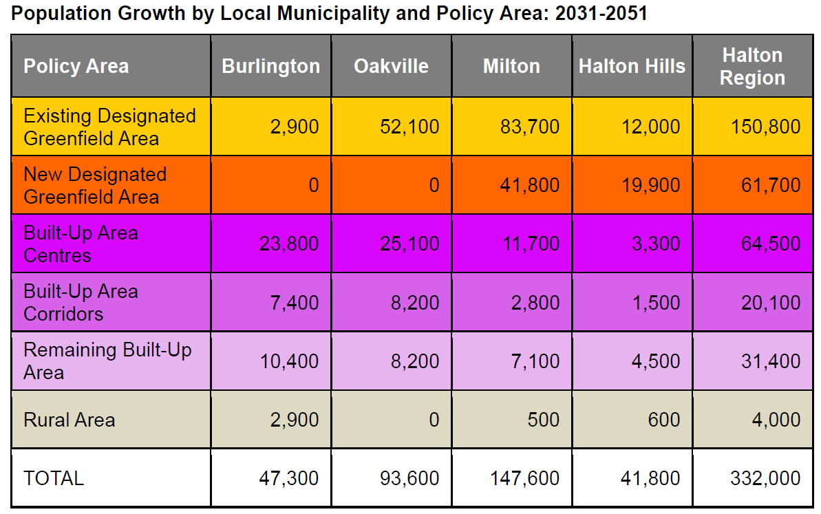
The preferred scenario; 1) satisfies Provincial tests to accommodate foreseeable market demand, providing homes for a small number of families who wish to live in a home with a backyard and a garage. That means the Province will likely approve the plan, but not 3a or 3b; 2) increases the number of people who will live in newly constructed apartments representing about 60% across the Region, but more like 90% in the City of Burlington, which is essentially what you are advocating for. Reducing the Burlington allocation to 70,200 population lowers the number of apartment buildings by 25 to 37.5 buildings, providing a bit of a breather to the community. Please take a moment to visualize what the Burlington skyline, living conditions and congestion is likely to become, even under the preferred scenario.
 Keep in mind, this plan follows the 2018 election when the people of Burlington spoke out clearly that they do not wish to see “over intensification” of their hometown. It is not what anyone wanted. Keep in mind, this plan follows the 2018 election when the people of Burlington spoke out clearly that they do not wish to see “over intensification” of their hometown. It is not what anyone wanted.
In any event, the City will experience increasing numbers of apartments not only between now and 2051 but even more for years too come. The same will be true for the other Halton municipalities. The preferred scenario simply delays inevitable further densification of Halton.
I will be pleased to discuss this with you if that will help.
 By Don Fletcher By Don Fletcher
January 13th, 2022
BURLINGTON, ON
An earlier version of this article included illustration that were out-dated. The illustrations have been revised.
We are pleased to learn from this update that Phase 4 of this study has restarted, and to understand somewhat why the study was placed on hold in mid-2018. Given that we’ve suffered through a pandemic over the last few years, it’s understandable why it wasn’t resumed earlier.
 A study on the best way to develop this area began in 2015. The delay in completing the Waterfront Hotel Planning Study as originally planned is still potentially problematic. In Section 3.3 of Bousfields’ Planning & Urban Design Rationale that was part of the Burlington 2020 Lakeshore Inc.’s development application submitted on October 26th, 2021, their rationale for requesting the removal of Policy 5.5.9.2(l) of the in-force Burlington OP, as amended, was that this study had an “indeterminate deadline” with a further characterization that it “has never been completed, indefinitely sterilizes the subject site from redevelopment and from achieving its highest and best use potential”. It is not clear to us whether the property owner ultimately plans to ignore the guidance of the Waterfront Hotel Planning Study, but it is clear that completing it on a highly accelerated basis must be a top priority.
Citizens’ PLAN B remains committed to the extension of Spencer Smith Park and the enhancement of the Brant Street gateway to Lake Ontario, through the application of the ‘Thin Red Line’ design principle related to the Waterfront Hotel Redevelopment. Yes, we understand the changing context of the NE corner of Brant Street & Lakeshore Road with respect to the origins of the ‘Thin Red Line’, but it still has great utility in its’ application to achieve what most residents want in the redevelopment of the Waterfront Hotel property and remains a simple concept that resonates with everyone.
A citizens group – Plan B – introduced the concept of a thin red line. Will it be enough and will it ever be adhered to? We understand that City staff with support of project consultant, The Planning Partnership, will resume the work plan where it left off in 2018. This update references Section 3 of Report PB-23-18, which contains 16 key policy directions, as one of those milestones that can be built upon.
PLAN B fully supports PB-23-18.
Application of the ‘Thin Red Line’ will help fulfill Public Realm policy directions 5a, 7, 8 and 9, which in our opinion are not achieved in the current development application.
One deliverable that was not mentioned in this report but should also serve to expedite completion of the project is Emerging Preferred Concept #3. I have attached a Planning Partnership Jan/ Feb 2018 Overview/ Snapshot of its’ evolution for your reference, with some of the rationale for selecting EPC #3 noted there re-iterated below:
Achieves the Urban Design objectives for the Downtown
Achieves a Floor Area Ratio (FAR) that balances the base permissions of 5.0 with the Developer’s Current Concept of 7.5 FAR
Buildings located east of the ‘Thin Red Line’, representing the view corridor south of Lakeshore Road, proposed by the Downtown Mobility Hub Study. A new significant open space defined by the ‘Thin Red Line’ located on the west portion of the property, contiguous with the waterfront park
Buildings that provide a clear landmark visible from the park, Brant Street, John Street, Lakeshore Road & Lake Ontario
A potential development yield that is viable and provides some incentives for redevelopment.
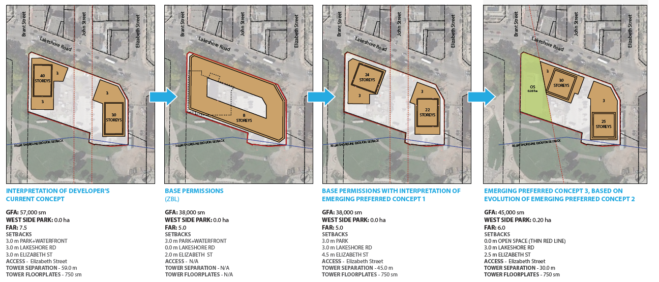 Panel 1 is what the developer originally proposed, panel 2 is what is permitted on the site, panel 3 is one of the alternatives that didn’t include any resident input panel 4 is the last iteration of concepts being considered in the planning study. This was the last iteration of conceptual designs that we were party to, and while we fundamentally supported it, we through Ramsay Planning Inc. submitted a few minor improvement suggestions. We are unaware of Vrancor’s feedback.
We acknowledge and respect the current property owner’s right to profit from his investment, and that this will necessitate a “reasonable” amount of massing and building height. We also believe passionately that the impact of this development will be felt by many future generations of Burlington residents & visitors, and collectively we must get it right. Citizens’ PLAN B is completely open to work with all stakeholders to help make this a “win-win” scenario.
Follow Plan B at: www.planbwaterfrontredevelopment.ca
Related news stories:
What about a land swap?
Plan B has been pressing city council for years
By Pepper Parr
January 10th, 2020
BURLINGTON, ON
Council is going to hear a report this week on the The Waterfront Hotel Planning Study that was undertaken to comprehensively plan the waterfront site at 2020 Lakeshore Road and guide the landowner in its redevelopment.
Given that the site has been referred to as Ground Zero for Burlington an in-depth study made a lot of sense.
The Waterfront Hotel Planning Study will inform an implementing Official Plan Amendment. Once approved, that amendment will form part of the City’s Official Plan and provide a strategic framework to guide the redevelopment of the subject property.
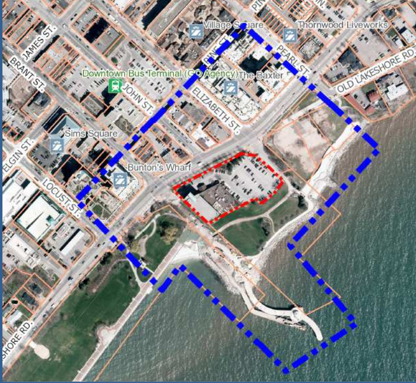
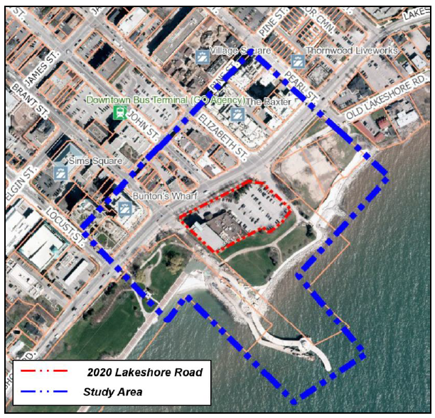 Notice the space between the southern part of the dotted red line and the edge of the lake. Who owns that property? Is it part of the hotel land or is it controlled by Conservation Halton? That’s an important question. The Study began in early 2017 and included three public meetings/community workshops (a total of six sessions) and two community surveys. In November 2017, an update on the status and progress of the study was presented to Council at the Planning and Development Committee Meeting. This community and stakeholder engagement phase first explored eight design ideas, which were then refined to three preliminary design concepts, and then two emerging concepts.
As a result of additional community and stakeholder input in early 2018, a staff report was brought to the Planning and Development Committee in June 2018. At that time, a set of key policy directions to guide the development of a final concept were endorsed by City Council. These key policy directions were organized around the design principles of Land Use and Built Form, Public Realm, and Mobility and Access.
In mid-2018 the Study was placed on hold due to other various priorities in the Community Planning Department such as the New Official Plan process and for staff to re-visit the Study workplan while considering the set of key policy directions endorsed by Council in June 2018.
While all the futzing and putzing was going on the developer beavered away at doing the design work and taking part in a pre-consultation meeting required to submit a development application.
 The design is world class – the architects have made excellent use of the different views that will be available. That application was submitted, but deemed to be incomplete by the planning department.
So what is the point of returning to the Study – the developer has wind in his sails and is on his way.
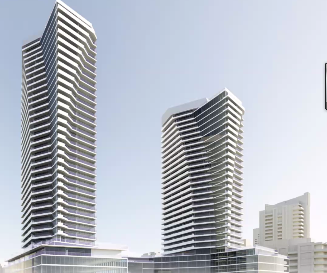
The Staff report makes mention of “height not to exceed three (3) storeys within 20 metres of Brant Street and Lakeshore Road and eleven (11) storeys adjacent to John Street and beyond 20 metres of Brant Street and Lakeshore Road” while the developer presents a plan for two towers that are very close to the southern edge of Lakeshore Road and soar 35 storeys high. The second tower is just 30 stories high. Both sit on a five storey podium.
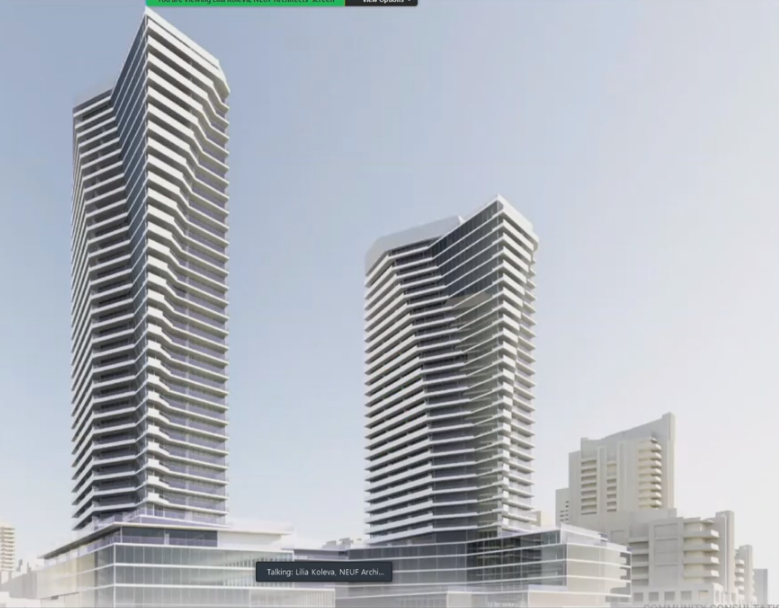
The design of the buildings is superb, these are very smart looking buildings that would be a delight to live in. The plan puts them in the wrong place. One wag described the development as “out of proportion; out of place and should be outa here”
 The northern edge of the site is very close to the edge of Lakeshore Road. The five storey podium will loom over the street – with no view to the lake. The entrance to the east end of Spencer Smith Park will be through an opening in the podium. The surrounding context of the Waterfront Hotel Planning Study Area including changes to the northeast corner made through the scoped re-examination of the New Official Plan Project, will be considered in the development of the preferred concept for the Subject Property.
This will also include a review of the key policy directions endorsed by Council in June 2018, including the amended key policy direction #8 which was modified by Council to include the following language in bold text:
 Enhance the Brant Street view corridor to frame views to the Brant Street Pier, and require a significant building setback from the west property line and define and consider a building setback from the thin red line and maximize the new and enhanced publicly accessible green/open space. Enhance the Brant Street view corridor to frame views to the Brant Street Pier, and require a significant building setback from the west property line and define and consider a building setback from the thin red line and maximize the new and enhanced publicly accessible green/open space.
That “thin red line” concept came from the Plan B, a group of citizens that believe something much better can be done with the hotel site.
It was a solid idea but the city planners found a way to get rid of the idea. At the January 23, 2018 Planning and Development Committee a council motion was carried to modify the block shown at the northeast corner of Brant Street and Lakeshore Road located in the proposed Cannery Precinct (22-storeys) to the Downtown Core Precinct with a maximum building height of 17-storeys including community benefits.
As a result of Council’s modification, the basis for the expanded public realm at the corner and enhanced setback limit was eliminated.
On April 26, 2018 City Council adopted a new Burlington Official Plan. On December 4, 2018, the Region of Halton issued a Notice of Non-Conformity to the City, which had the effect of extending the Region’s review process until such time as the Region determined that the non-conformity was rectified. While collaborating extensively with Regional staff on the issues of non-conformity the City undertook the scoped re-examination of the adopted Official Plan. This process took place while the Waterfront Hotel Planning Study was on hold.
Through the scoped re-examination of the New Official Plan Project in 2019-2020, the adopted Official Plan policies for the Downtown were studied. As part of that work the north-east corner of Brant Street and Lakeshore Road was revisited and was included within the Brant Main Street Precinct. The purpose of this precinct was to serve as a unique retail destination within the Downtown and city-wide.
The precinct provides a wide range of policies to guide development within the precinct. Specifically, related to built form, this precinct requires height not to exceed three (3) storeys within 20 metres of Brant Street and Lakeshore Road and eleven (11) storeys adjacent to John Street and beyond 20 metres of Brant Street and Lakeshore Road. In November 2020 the Region of Halton approved Burlington’s New Official Plan, which is currently under appeal.
The Subject Property was not included in the scoped re-examination of the New Official Plan Project and the new Official Plan did not change the existing land use designation and permitted building height for the Waterfront Hotel property located at 2020 Lakeshore Road.
 Former city Councillor John Taylor in discussion with Linda Davies and Dee Dee Davies during one of the six public sessions that were held shortly after this Council was elected. The Gazette was asked to leave the room, at the instructions of the Mayor, when the conversation between the stakeholders was taking place. Next Steps
With the re-examination of the New Official Plan (Taking a Closer Look at the Downtown) Project completed, approval of the new Official Plan (under appeal), as well as the Minster of Municipal Affairs and Housing’s approval, with modifications, of the Regional Official Plan Amendment 48 it is the appropriate time to resume the Waterfront Hotel Planning Study.
City staff with support from the project consultant, The Planning Partnership, the group that is leading the consultation process will resume the workplan where it left off in 2018 to complete the study. The work is anticipated to take 16-17 weeks and will be completed within the original project budget. The resumption of the study will build upon and advance the previous work and community input to-date to develop a final preferred concept.
There is a much better solution on what can be done with the hotel site.
A small group is working at building public support for a different look at the waterfront hotel site that includes possible land swaps and building a new city hall on the property; something that would be four or five storeys high and include a purpose built Art Gallery.
Burlington can do better than the application before the Planning department. There are limits on what developers should be able to do.
This is a story that is going to be around for some time. It is your city.
Related news stories:
More on Plan B
Some ideas on what is possible
 By Pepper Parr By Pepper Parr
January 4th, 2020
BURLINGTON, ON
The three things the city wants to focus on in 2022
Fractious council
Losing the football
Waterfront Hotel
With nothing but virtual Council meetings for just about two years now it is difficult to read just what is taking place.
 Councillor Kearns is missing the Standing Committee Clerk and the City Manager are included If you know the players a little you can pick up some of the discord – and there is certainly discord but this council works very hard to ensure that very little of it gets seen by the public.
The hope that many Burlingtonians had, including this reporter and the Gazette, when Marianne Meed Ward bent her head forward as the Chain of Office was placed around her neck is not today what it was that December evening in 2018. The hope hasn’t entirely disappeared but there is discord and differences.
Council is split into two factions: The Mayor who will be supported by Rory Nisan until the day he is no longer in office and Kelvin Galbraith who likes the way the Mayor accepts his – let’s build stuff approach to being a ward Councillor.
One the other side, Ward 2 Councillor Lisa Kearns, Ward 4 Councillor Shawna Stolte and Ward 5 Councillor Paul Sharman are usually on the same page – and it is seldom the same page as the Mayor.
The factions are not cast in stone with Nisan being the exception.
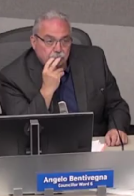 The swing vote – didn’t see that coming in 2018 The swing vote is ward 6 Councillor Angelo Bentivegna (who’d thought this is how things would work out) who has taken to developing his own view on those matters he understands. And while he is frequently with the Mayor – not as much as he used to be.
Five of the seven members of Council have now been in office for three years and are gearing up for re-election. With one exception the expectation is that all seven will seek re-election. And no – I am not prepared to say who the exception is at this point.
The important things is the the newbies have found most of their footing – they have developed a good working relationships with their constituents; feel comfortable with most of the issues and are tiring of the way the Mayor treats them. Lisa Kearns thought she would like to serve on the Police Services Board and chose to put her name forward. The Mayor did not support Kearns – and the seat went to a Council member from Oakville.
Traditionally members of a Council support each other when they have something they want to do outside of Council. Meed Ward may have had some very good reasons for supporting someone else for the Police Services Board but common courtesy called for her to talk to Kearns and explain her position. Kearns was apparently blind-sided by the Mayor.
 Without a doubt the quickest and the fastest mind on Council; a workhorse as well – does her homework Kearns, by the way, would have been an excellent Police Serve Board member – she does her homework (better than anyone else on Council) she would have kept the Board members on their toes.
 Councillor Stolte looking for some clarity. When Councillor Stolte isn’t asking for additional clarification on a matter she struggles to get around the interference the Mayor pushes in front of her.
If Stolte has an event going on and invites the Mayor – it becomes the Mayor’s event.
The differences in approach and philosophy became glaringly obvious when the Mayor could not find a way to get the tax increase number she felt she needed going into an election in October.
Her thinking had merit – it deserves an explanation and some analysis and in the fullness of time we will get that to you.
Meed Ward had a well thought out position – the other council members just didn’t buy it. This Council came very close to being in a position where they were not able to agree on a budget which would have put the creating of a budget in the hands of staff – which City Manager Tim Commisso advised would “not be a pretty picture”.
There are times when the Mayor bends over backwards to get her colleagues to “collaborate” with her. The city does not have someone serving as Deputy Mayor because the members of Council could not agree on just what the job would entail.
When the Burlington Land Partnership was set up every member of Council wanted to be on it – wasn’t something the city manager wanted so no one sits on the BLP – which by the way is a significant venture that the general public knows very little about.
 Transparency became her middle name – she draped it around her like a flag In 2010 there were three new members on Council. Meed Ward, newly elected had a lot of time in as probably the leading delegate as a citizen knew the ropes. Paul Sharman had a lot of senior executive experience in the private sector and knew his way around process and financial reports. The only really new ember in 2010 was Blair Lancaster. There wasn’t nearly as much learning on the job for the newbies.
And Rick Goldring who had become Mayor had a good feel for what the job was about – which is not the same thing as being able to actually do the job.
 Normally wears a winning smile. Meed Ward is now in a similar situation. She is Mayor but has yet to create the set of skills needed to make it happen. Politics is the art of the possible with grey being the dominant colour – black or white doesn’t work. Meed Ward doesn’t do grey.
Listening intently and being able to read the wind as well as the tea leaves in a cup are vital. It is an art with an understanding of the little bit of science that matters.
What a Councillor is made of should be evident by the end of the third year of the term – and with Meed Ward it is evident but it isn’t all that useful.
 Expensive but well worth the price – great legal counsel solved a problem for the ADI Group – shovels are in the ground and the cranes are hauling concrete. There have been some major wins. The Mayor managed to get rid of the Planner in place when she was elected. She did get the Urban Growth Centre moved north and proved that the a bus terminal that is the size of the average kitchen is not an MTSA – despite what sharp legal counsel was able to convince an OMB hearing that it was. That was a big win for the ADI Group
Meed Ward seems adrift when it comes to solving the football, almost missing in action on the redevelopment plans for the Waterfront Hotel.
She gave Black Lives Matter the coverage it needs and then got totally silly with her drive to put Rainbow Crosswalks in every ward while learning to live with a budget that needed some time in a Weight Watchers class.
In 2018 the Gazette said Meed Ward was the best of the three people running for the job. We expected her to grow into the job – that hasn’t happened and unless she has a horse shoe in her purse that can be put to good use, or knows how to pull a rabbit out of the hat, she is in trouble.
 Rick Goldring seldom wore his chain of Office outside Council Chambers So much so that Rick Goldring is understood to be looking at his chances of once again wearing the Chain of Office.
 Ward 5 Councillor Paul Sharman is usually very direct, tends to want to see data that is verifiable and expects to get his way. Are there other candidates that might want to reach for that brass ring? There are – but they are nowhere near ready to show their hand.
As for the members of Council Meed Ward will have the support of at least two – one of which may not win his seat come October 2020.
The problem with the football and the strange situation with the Waterfront re-development project will follow.
Salt with Pepper is the musings, reflections and opinions of the publisher of the Burlington Gazette, an online newspaper that was formed in 2010 and is a member of the National Newsmedia Council.
|
| By Staff
January 4th, 2022
BURLINGTON, ON
WE are about to get a first look at what has come out of the meetings that were to determine what the development at the GO stations could look like.
A 250 page report has been released and will be debated at the January 11th Community Planning, Regulation and Mobility Committee Meeting.
Council will consider ‘in-principle’ endorsement of the Recommend Preferred Precinct Plans for Burlington’s Major Transportation Areas.
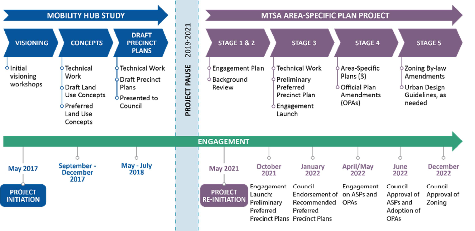 The time line that is currently in place Council’s endorsement is a critical check point in the project that will enable staff to move forward to the next stage of the project which involves the creation of area-specific plans and supporting Official Plan Amendments for each of the MTSAs.
The Interim Report prepared by Dillon Consulting provides:
- The project background and context
- The policy and legislative context for MTSAs
- The work underpinning the MTSA ASP Project and the Preliminary Preferred Precinct Plans including key growth assumptions and complete community elements
- A discussion about how public engagement informed the Preliminary Preferred Precinct Plans
- A summary of the technical work required to support the project and a status update on each
- An outline of the changes made to the Preliminary Preferred Precinct Plans resulting in the Recommended Preferred Precinct Plans and the underlying policy directions to support them and the future area specific planning process
- Next steps and conclusions
The staff-prepared Fall 2021 Feedback Report outlines each of the tactics undertaken during October and November to engage with the public around the Preliminary Preferred Precinct Plans and includes the methodologies used, the results of the engagement or feedback received as well as some of the lessons learned.
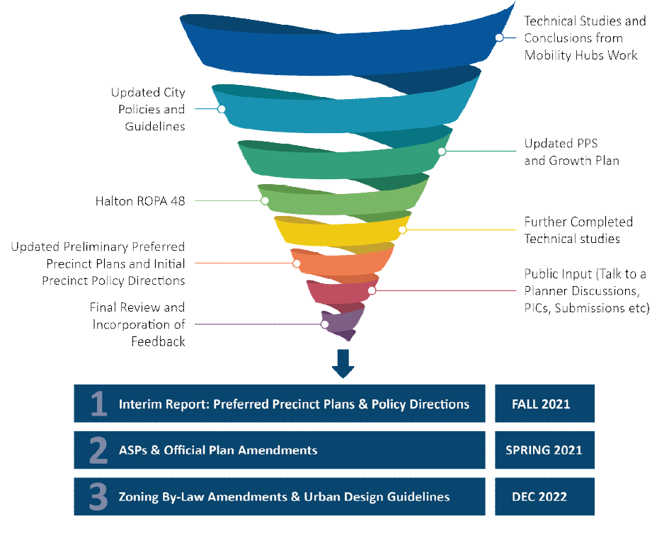 The steps that have to be taken to arrive ast an Area Specif Plan. There will be one for each of the GO Station MTSA’s Further changes to the Recommended Preferred Precinct Plans are expected and will be required as a result of technical studies underway, as well as other inputs including Council and stakeholder feedback and further project work.
The very unfortunate part of the process is the severe limitations COVID19 will put on genuine public participation and serious delegation.
The number of delegations that have been heard has been reduced significantly.
 Alison Enns watching a group of participants on a walking tour. Also – the opportunity to read a 250 page report a week before it is debated at council isn’t being fair to the public that is going to live with whatever is decided upon for decades.
The Gazette will read the document and report on its contents and provide some analysis.
This is difficult for staff as well. They have worked very hard on this project; they know how significant the final decision will be and everyone on the team would love to hear some sound community response. |
|
|
|
By Pepper Parr
January 1st, 2022
BURLINGTON, ON
Sticky bit of news came out the last few weeks of last year. It will probably be the top story between now and the municipal election this October.
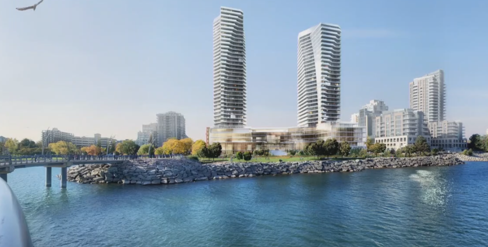
The hotel is set back from the street, does not loom over the road, gives a clear line of site to the Pier On a site referred to by the planner for the developer as Burlington’s Ground Zero, there are plans to demolish the existing Waterfront Hotel and build two towers: one 35 storeys, the other 30 storeys.
What makes it sticky is some of the politics. The city has created a new Official Plan that still has a few steps to go before it is THE Official Plan.
There were changes in where growth was to take place in the plan. More than 40 organizations have filed appeals against different parts of the Official Plan – which is not all that unusual.
The podium will butt up against the street and have the two towers on top What was unusual is the grandfathering of a development application that city council has said is not complete.
For the average Burlingtonian all this politicking doesn’t get much attention – however the eventual results will have a very significant impact on Spencer Smith Park which is seen as the jewel in the crown that is the city’s waterfront.
A small group of people formed Plan B – which sets out what the downtown lake edge and the core of the city could look like – if only there were real citizen input.
Plan B really wants your help.
They are arguing that it is your city and you deserve the right to have input on decisions made.
On the political side the provincial Minister of Housing announced that the incomplete application to redevelop the Waterfront Hotel site would be grandfathered, that it will come under the old Urban Growth centre.
 From this – the site as it is today…
... to this. The planning proposal currently before the city. You may have heard that the application for the Waterfront Hotel redevelopment was submitted to Steve Clark, Ontario Minister Of Municipal Affairs & Housing, on November 10th, effectively eliminating two intensification arguments (MTSA & UGC designations) used by developers trying to justify increasingly high condo developments downtown.
That’s all true… but did you know that the City in a 7-0 unanimous vote of Council supported the Planning Department’s recommendation to deem the application incomplete.
It seemed logical to the PLAN B group that this application should be re-submitted when it was complete.
For those who care about how the downtown core of the city is developed and what happens to Spencer Smith Park the Plan B people ask you to “Stay tuned, because things have just gotten a lot more interesting!”
Follow what they are up to on their Facebook page. Click HERE
Related news stories:
There are other options
 By Ryan O’Dowd: Local Journalism Initiative Reporter By Ryan O’Dowd: Local Journalism Initiative Reporter
December 29th, 2021
BURLINGTON, ON
The worst of the pandemic was over, for the time being, or so we thought – July was a month of a cultural boom for Burlington.
A dark cloud hung over Canada Day as the national zeitgeist remained contemplative over Canadian identity and its relationship to residential schools and a broader problematic history with Indigenous peoples.
Nevertheless, Burlington pressed onwards. The Sound of Music put on a virtual show featuring some of our top local talent. It wasn’t the same as spending a weekend at a rapturous, muddy Spencer Smith Park enjoying the spectacle but the event was a solid effort to entertain Burlington in a safe, socially distanced way.
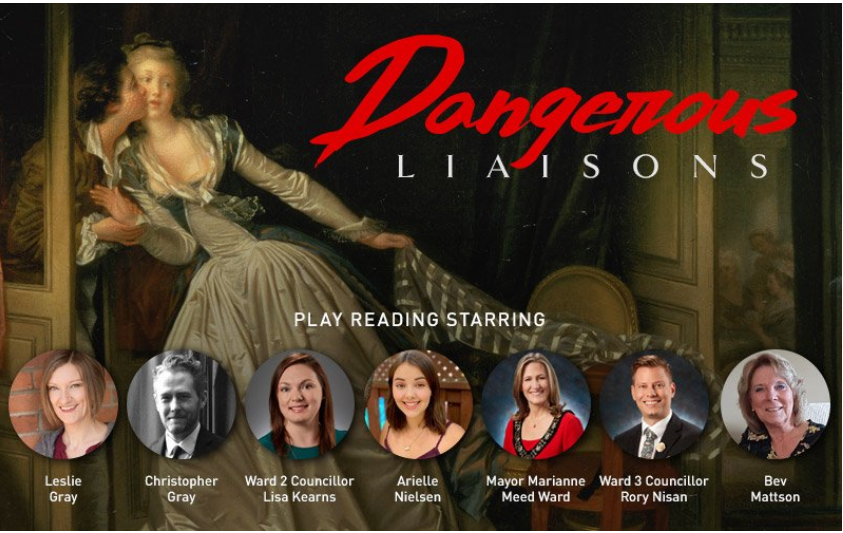 The Mayor and a city Councillor were featured in an online reading rendition of Dangerous Liaisons. By the end of the previous month, online entertainment in Burlington consisted of City Staff and the Mayor starring in productions of Dangerous Liaisons and The Odd Couple. This reporter is sure they did a fine job but is equally as sure they were happy to see the professional entertainers back. The Sound of Music featured Indigenous speakers but as a Gazette contributor pointed out they didn’t showcase any Indigenous artists, a missed opportunity, all things considered.
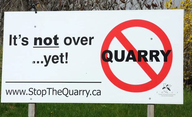 Citizens Group continues with a long drawn out protest over plans for an enlargement of the Nelson quarry. Education-based events came out of the Performing Arts Centre, which hosted a mid-July Musical Theatre Week. The Burlington Public Library added items to their lending program to encourage outdoor fun, including bikes, games, and hobby items (such as bird watching kits and archery sets).
The library was a great source of entertainment throughout the pandemic, seeing a 103% increase in eCheckouts of books (they also expanded their collection) after closing their doors. Brant Museum re-opened featuring a space exhibit. Elsewhere, the community was beginning to be able to organize again, a bedrock of a functional democracy.
CORE Burlington (Conserving our Rural Ecosystems) hosted their first event since the start of the pandemic to oppose Nelson Aggregate’s Mount Nemo quarry expansion application.
The City of Burlington invested $25,200 into the 2021 Neighbourhood Community Matching Fund recipients. The community investment went towards three community projects, focused on enhancing infrastructure amenities within parks, gardens, and buildings on public lands or on lands that are accessible to the public. The winners were Grow for Change Urban Farm Community Therapeutic Programs, The Orchard Community Garden Project, and Community Garden in Roseland.
City Council prepared to break for the summer but still had their share of business. They began work on the 2022 budget, more on this in the final quarter – an early figure included a city tax increase of 5.57%.
 On July 6th Laura Boyd, Executive Director of Human Resources, gave a presentation to staff on the problems the City is facing to attract needed staff, and to keep the staff they had. Despite heading into summer break the City remained in a declared State of Emergency which put the day-to-day running of the city in the hands of the Emergency Control Group (ECG). As a result, Council gave the city manager delegated authority to spend $250,000 without referring to the council before getting the cheque signed in case of an urgent matter, he just had to tell them how many times he spent $250,000. On July 6th Laura Boyd, Executive Director of Human Resources, gave a presentation to staff on the problems the City is facing to attract needed staff, and to keep the staff they had. Despite heading into summer break the City remained in a declared State of Emergency which put the day-to-day running of the city in the hands of the Emergency Control Group (ECG). As a result, Council gave the city manager delegated authority to spend $250,000 without referring to the council before getting the cheque signed in case of an urgent matter, he just had to tell them how many times he spent $250,000.
On July 12th the City had to pony up $165,000 to get parking sensors in downtown Burlington that were accurate, this was a fix to a problem in the completion of a project allotted $525,000 in 2017. Gazette readers wondered if we needed sensors tabulating the number of cars in a parking lot and expressed frustration over the growing costs. The City of Burlington announced the appointment of Maciej Jurczyk as the City Auditor starting August 16, who, arriving at a tumultuous financial time, would surely have his work cut out for him.
 The Rainbow Crosswalks were a story that destined to have a long run. Expect them to be an election issue at the end of the year we are going into. Elsewhere, the Gazette continued to follow the rainbow crosswalks story, aside from the vote on location (right in front of the Halton Catholic School Board office), another story was brewing. The Gazette reported belief from observers that Marianne Meed Ward threw three of her council colleagues under the bus when they voted against the Mayor to have six additional rainbow crosswalks done as soon as possible, rather than the more fiscally prudent approach of adding one each year. The Mayor wanted to again raid reserve funds to pay for the additional six – Kearns, Stolte, and Sharman had no problem with the crosswalks – just not all at the same time. The Mayor tweeted out thanks to her councillors other than Kearns, Stolte, and Sharman, which some took as a suggestion they didn’t support the 2SLGBTQIA+ community, which was not the case.
As for regional growth plans, big problems for the city were on the horizon. That sentence is quite literal as big developments in downtown Burlington, begun under the former Major Transit Station Area and Urban Growth Center designations, looked impossible to stop. The Gazette congratulated the Mayor and Council on their achievement in shifting these designations to keep high-rises out of downtown Burlington but some of them were poised to be grandfathered in while the City’s Official Plan stalled. After all the fights, including some successful ones the City waged with the Region, downtown Burlington was fated to be forever changed. The City won but lost.
Halton Regional Police Services announced their use of the Brave App, designed to connect people at risk of overdose with the help they need: an ally they can talk to, a human supporter to help them stay safe, and digital monitoring technology to help them when they’re in danger. The app connects them with a community of overdose responders, and/or professional emergency first responders. The use of the app was in response to what they called an overdose crisis in the community.
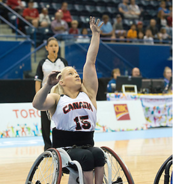 Local wheelchair basket player Melanie Hawtin joined the Canadian Team representing Canada at the Tokyo 2021 Paralympics. On July 20th , a local wheelchair basket player, Melanie Hawtin, was announced to join the Canadian Team representing Canada at the Tokyo 2021 Paralympics.
Rumblings of a federal election call began early in August. In preparation, the Green Party announced their candidate, a young man named Christian Cullis, on August 10th. On August 12th the Gazette began investigating rumours of a Burlington People’s Party candidate, who was revealed to be Michael Bator shortly thereafter.
On August 15th the Gazette reported on some conveniently timed Burlington investment announcements by MP and Cabinet Minister Karina Gould who used the Rock Garden in Hamilton to announce that the federal government had come up with $579, 000 from the Great Lakes Action Plan V – Great Lakes Sustainability Fund for the RBG’s Wetland Rehabilitation Program and the City of Burlington’s Grindstone Creek Erosion Control Planning. The RBG would be receiving $425,000 for their program, while the City will be receiving $154,000.
Ahead of the election call Gazette field reporters surveyed Burlingtonians about their feelings on the election, most felt it was unnecessary, irresponsible, even a dereliction of duty by the federal government in some cases.
Others shrugged it off, believing whoever was in power would make a similar gambit if they liked their chances to re-election. Nevertheless, the election was called on August 15th, that it was called at all would remain a defining election issue.
The Gazette began profiling the players, starting with every major party candidate in Burlington and spoke to those candidates who were interested. In August the Gazette profiled Gould, who championed the $10 a day child care program as the cause dearest to her (upon re-election she would be named Minister of Families, Children, and Social Development). NDP candidate, Nick Page, and the Green Party’s Cullis, shared similar visions of a more equitable society and saw emerging from the pandemic as the opportune moment to consider some foundational changes.
Page and Cullis were so closely aligned that when the NDP candidate pitched proportional representation his pitch was that the Green Party would have a bigger voice in influencing climate change. It was an example that had our editor run a piece with the question “huh?” in the headline. The Gazette’s fruitless efforts to speak to Conservative candidate, Emily Brown, were well documented. They had to be after the first piece on Brown sent readers into a tizzy.
 Emily Brown, federal Conservative candidate for Burlington is ranked as a sharp shooter – missed the bulls-eye during the election. Brown neglected to engage with the media herself so the Gazette dug into what information was available, at the heart of her platform was protecting gun owner’s rights. It was an issue Brown was extremely passionate about, she is an accomplished shooter and held several positions within local shooting groups. For whatever reason Brown supporters didn’t like this, a self-identified, core tenant of her campaign being highlighted, they objected greatly to any Brown article without any factual objections.
 NDP sign defaced during the federal election. Early in the campaign, Oakville/North Burlington NDP candidate Lenaee Dupuis had a lawn sign vandalized with the words “No Commies” spray-painted on it, which would prove to set a regrettable tone for the campaign. The race was afoot and would continue into September.
With City Hall off for the summer municipal affairs in Burlington went mostly quiet, but regional development disputes continued to pile up. Mayor Meed Ward had thus far succeeded – there are new Urban Growth Centre boundaries in place and once the Official Plan gets completely approved – it was in the hands of the Ministry of Housing and Municipal Affairs –all it had to do was get through the 40 some odd organizations appealing – to become the law of the land. But business at Ontario Land Tribunal (OLT) moves glacially. The 40+ people and organizations appealing the adopted but not in force Official Plan wanted to see time frames and firm commitments from the City of Burlington and Region of Halton in order to bring the appeals to a conclusion.
Instead, proceedings got kicked further down the road when the city and region failed to provide a consolidated list of issues by the assigned deadline. The future of development in Burlington hung in the balance and it seemed like the OLT met every couple of months just to schedule their next meeting and break for lunch.
In other city news, staff would be required to be vaccinated. On August 24th an application was made for a holiday market on the Elgin promenade, with no word on who made the application, this story would develop as the year went on.
 The walkway at Crawford Lake was a popular destination once people were able to get out. For most of Burlington not too deeply entrenched in the mire of politicking, August was another promising month. Hassaan Basit, President, and CEO of Conservation Halton said that from January until August, their parks saw around 850,000 visitors, which is a 30 to 40 percent increase from last year. People were getting out in droves, more people were being vaccinated, more businesses were open, the comparatively rosy COVID-19 outlook in July continued in August, as opposed to the taking one step forward and two back we’d grown accustomed to.
The Gift of Giving Back operated an event different from what it was best known for. From its inaugural 2007 event up until 2019 the Gift of Giving Back would pack gymnasiums full of food bins with the help of community sports teams and students.
COVID-19 put a halt to their traditional food collection method in 2020, but they still found ways to contribute.
The Royal Botanical Gardens hosted an Enchanted Garden Tour, a full kilometer long, leading through the Rock Gardens and hosting six different stations for kids to learn about this year’s theme, the monarch butterfly. Kids clad in fairy wings as colourful as the monarch butterflies themselves were giddy on the tour. Burlington Artscape showed off local artists who lent their time to create paintings on leaf canvases sold in support of the Joseph Brant Hospital Foundation.
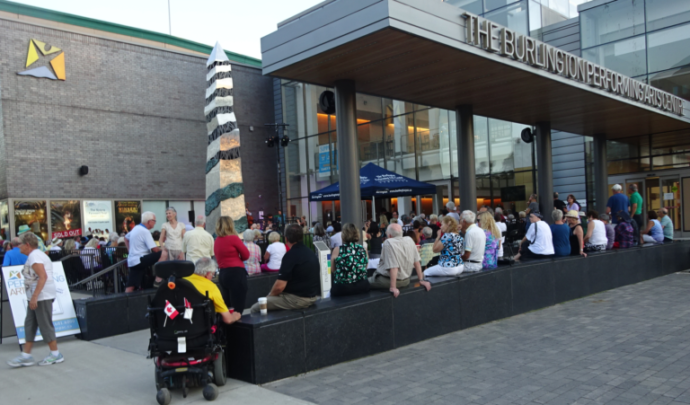 Respecting the social distancing rules was easier said than done at the August outdoor patio jazz event at the Performing Arts Centre The Performing Art Center put on sold-out jazz shows on patios, not a computer screen, patios sat with real live people in the flesh. Live shows were put on by Bling International at the pier. The live music events were in recognition and celebration of Black, African, Caribbean, Canadian appreciation month.
The federal election dominated much of September. The Gazette interviewed candidates across Burlington’s three constituencies and by the time ballots were cast most major party candidates had participated. Emerging issues among all candidates included COVID-19 recovery and vaccine passports, housing, cost of living, climate change, reconciliation with Indigenous communities, and that the election itself was taking place at all.
Environmental debates took place, which Conservative candidates in Burlington and Oakville/North Burlington opted to avoid causing latecomer Oakville/North Burlington Green Party candidate, Bruno Sousa, to slam their absences as “infuriating.”
As election night approached, Gazette reporters took to the streets to get a sense of the biggest issues on the public’s mind, there was much overlap with the candidates there. The majority of those surveyed still didn’t want an election to take place, but it had shrunk to a slight majority with nearly half of respondents split between being in favour of the election happening or not counting it among their priorities issue-wise. The Canadian Coalition for Firearm Rights arrived in Burlington just before the election. In a note to their members, they said they were there so “voters can learn the truth about the Liberal party. The mainstream media will never give voters an honest overview of a future under more Liberal government.” It’s the kind of fringe language that might’ve done more harm than good but at this juncture, this kind of discourse had been a reality of the campaign.
 Burlington MP Karina Gould wearing her campaign colours campaigned harder than she had ever campaigned before – and won – again. Same with van Koeverden, v and Pam Damoff. It was a clean sweep for the Liberals in the Burlington, Oakville and Milton ridings.   The ballots were cast, Gould, van Koeverden, and Damoff retained their seats in the Burlington ridings. Nationally the country ended up with a Liberal minority government. The ballots were cast, Gould, van Koeverden, and Damoff retained their seats in the Burlington ridings. Nationally the country ended up with a Liberal minority government.
What lingered was the hostility of it all. Several candidates called the campaign the nastiest they’d seen. The Gazette editor posted a similar reflection regarding bitterness in the election comment sections when the dust settled.
During this same month, Burlington’s Community Leaders had to release a statement speaking out against harmful messages, harassment, and misinformation targeted against our medical and healthcare professionals. It is behaviour as deplorable as it is misguided, front line workers do not make policy, and reflected the hostility that defined an ugly election season.
In less vitriolic election coverage news, three-quarters of a million students took part in a mock election, 5,478 schools across Canada participated and votes were cast in all 338 federal ridings. A good step in getting students acclimatized to the voting process.
If actually built – these two towers would be at what the developer called “ground zero” for Burlington. Towers were to be 35 and 30 storeys. On September 8th a virtual Pre-Application meeting took place for two towers: a 30 storey and a 24 story on Lakeshore Road between Brant and Elizabeth Street. During the presentation, given by people representing the developer, David Faletta attempted to convince viewers that the old Urban Growth Centre boundary would apply.
The City approved the Holiday Market proposal to run between December 9th and 12th with little in the way of public input and mixed reaction from downtown retailers. What’s more, they seemed to have signed off on the market as an annual event.
Creeping towards normalcy, Ward 2 Councillor Lisa Kearns held her first in-person ward meeting since the beginning of the pandemic – eight people attended. An additional 35 took part virtually.
September saw quintessential Burlington events like the Terry Fox Run at Spencer Smith Park. Team Casey’s Terry Fox Event followed suit, in honour of the late Casey Cosgrove, a man described as remarkable and an inspiring community champion, who too suffered from cancer. They played a baseball game wearing t-shirts with the following quote: “This disease will not take away my disability and wish to inspire,” Casey, 2017.
 Rib-Fest returned with a drive-thru BBQ event at Burlington Centre, a Food Truck festival took place at Spencer Smith Park, the month was full of activities. Rib-Fest returned with a drive-thru BBQ event at Burlington Centre, a Food Truck festival took place at Spencer Smith Park, the month was full of activities.
On September 30th Burlington hosted the Every Child Matters Truth and Reconciliation Day gathering at Spencer Smith Park. Organized by Amber Ruthart, a local Indigenous music studio owner, the event was informative, moving, and a celebration of Indigenous culture with song and dance.
“I hope that education continues and is not just a trend. Also, we hope to be doing more indigenous awareness social events in the future here in Burlington,” said Ruthart.
Speaking to the Gazette, Ruthart reiterated the need for reconciliation to be a constant consideration and not a trend. Event organizer Ruthart, said her native name translated into “loud voice,” her message was loud and clear.
By Pepper Parr
December 26th, 2021
BURLINGTON, ON
Trying for a quieter day,
Two stories – both development related, for Burlington is in full development mode. With 40+ development applications either with, or on their way to, the Planning department and about the same number of appeals of the adopted but not yet legal Official Plan before the Ontario Land Tribunal – the year ahead is going to be 10 months of arm wrestling before there is a municipal election – and who knows who the winners will be at that level.
Ward 2 Councillor Lisa Kearns sent out a piece she put up on her Facebook page with a link to the Plan B Facebook page.
The Councillor feels restricted on just how supportive she can be about what the Plan B people would like to see done with the Waterfront Hotel site that is the object of a development proposal for a two tower development that will set a new height level for the downtown core – a 35 and a 30 storey tower.
Named 2020 Lakeshore, the site is owned by Vrancor the owners of Solid Gold, an adult entertainment location in Aldershot, and the former Ascot Motel to the immediate east of the Bridgewater development.
The development application submitted to the Planning Department has been described as incomplete.
 The downtown core of the city would undergo a radical change if these two towers were built. Burlington as people know it today would disappear. What Kearns has managed to do is give the Plan B some much needed exposure. If what they have in mind is to gain any traction they need a lot more in the way of public support for something radically different than the two towers to be built.
 How hard can a ward Councillor fight to prevent a development. They are limited in what they can say about a development that has not yet been presented to Council In her Facebook page Kearns writes:
Are you passionate about Burlington’s Waterfront?
Can you lend your expertise & energy to a community group?
Here’s an opportunity to join a local growing movement to Add Your Voice To Help Save Burlington’s Heritage Waterfront.
Check out PLAN B. Waterfront Hotel Redevelopment
 PLAN B is a group of engaged Burlington volunteers solely focused on ensuring that any redevelopment of the Waterfront Hotel enhances the Brant Street gateway to Lake Ontario and extends Spencer Smith Park. She includes a link to the Plan B Facebook page. PLAN B is a group of engaged Burlington volunteers solely focused on ensuring that any redevelopment of the Waterfront Hotel enhances the Brant Street gateway to Lake Ontario and extends Spencer Smith Park. She includes a link to the Plan B Facebook page.
Related news stories:
Why Plan B is critical to saving what Burlington is
Citizens wanted input at the beginning – not after the planners have made their decision.
There are options and opportunities to be creative and serve the citizens and not the vested interests.
By Staff
November 30th, 2021
BURLINGTON, ON
With the provincial election more ta six months away – the political parties are getting serious and beginning to jockey for position.
 Ontario Premier Doug Ford – has always been business focused. The Liberals to say announced they would scrap the Ministerial Zoning Orders to Progressive Conservative government has used to permit development that municipalities may not want.
The Liberal media release, released this morning said: “Under the cover of a pandemic, Doug Ford has been abusing his powers and recklessly using MZOs to push through a list of rewards for his rich buddies over environmentally-sensitive land.
“Today, Ontario Liberals are releasing their plan to eliminate MZOs and bring in strict rules to ban Doug Ford’s abuses of power.
“Doug Ford has weaponized MZOs and is abusing his power to attack our environment and reward the well-connected few,” stated Ontario Liberal Leader, Steven Del Duca. “Ontario Liberals will scrap MZOs and bring in strict rules to protect our environment while responsibly building communities.”
 Ontario Liberal Leader, Steven Del Duca. does not have a seat in the provincial legislature. He was Minister of Transportation in the last Liberal government. Ontario Liberals would only allow fast-tracking of critical provincial projects, like affordable housing, employment lands/projects, and not-for-profit nursing homes to provide better care for our loved ones in communities across Ontario, or expansions to protected greenspace. Ontario Liberals would also add transparency measures, like required consultations and judicial reviews, to make sure projects respect environmental protections and aren’t being recklessly forced on communities like Doug Ford is doing now. The government would no longer be able to steamroll local communities to force through rewards for well-connected friends.
In just over three years, Doug Ford has issued 57 MZOs — more than triple the number that the last Liberal government issued over 15 years, and he expanded his powers three times. Ontario Liberals would give that power back to communities, making sure they are consulted on any critical projects the government advances.
“We desperately need to build more housing in Ontario,” added Del Duca. “Today’s announcement is about building more affordable housing, not-for-profit nursing homes, and creating jobs without attacking our environment. It’s about sustainable growth to build a better future for all of us.”
November 24th, 2021
BURLINGTON, ON
Some time ago a new online newspaper was created. Former ward 1 Councillor Rick Craven was a contributor. When we dug a little we learned that Rick Goldring was the person behind the creation of what is known as the Burlington News.
The following lengthy article on the Waterfront Hotel, is certainly detailed and both interesting and relevant to those who follow local politics.
There is no byline on the article.
Expect Rick Goldring to run for the office of Mayor in 2022. At this point, it certainly looks like he is positioning himself for a run against Mayor Meed Ward.
It has been confirmed: an application has been received by the City of Burlington proposing the redevelopment of the Waterfront Hotel, a 30- and 35-storey development to replace the existing hotel.
This application will now be considered following the usual planning process and is just one of the seven developments that remain to be considered using the city’s in-force Official Plan and policies in place prior to the approval of Regional Official Plan Amendment 48 (ROPA 48).
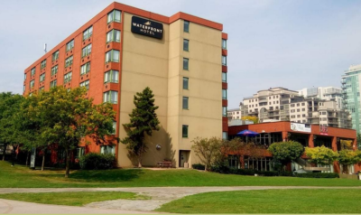 Its days are numbered – what replaces the hotel is the issue. There are a number of options. The Waterfront Hotel Study began in earnest several years ago, spanned two different mayors and has yet to be completed.
A little background to provide some context: in 2005 and 2006, the city approached the landowner to consider redevelopment of the Waterfront Hotel site (municipally known as 2020 Lakeshore Road). This was in response to a series of reports in 2005 and 2006 that considered the redevelopment of these lands and the important role they play in the downtown and the waterfront. City staff and the landowner at that time explored the advancement of a joint planning study process. A beginning of a planning review framework for the redevelopment of the site was developed and approved by council in fall 2006.
On February 23, 2015, council approved the terms of reference for the Waterfront Hotel Lands Planning Study, which is a comprehensive land-use and urban design study focused on the subject site and surrounding lands, including Spencer Smith Park. The Waterfront Hotel Planning Study was publicly launched, beginning with a pair of visioning workshops, in May 2017.
The boundary for the study and the boundary of the hotel property. The subject site’s significance was affirmed at the Planning and Development Committee meeting of November 28, 2017, evidenced by several delegations that presented a varied set of interests and development concepts. Since that time, staff, with support from the project consultants from the Planning Partnership that were hired by the City of Burlington, has undertaken additional consultation with stakeholders. This additional consultation was done in response to council’s direction to continue a dialogue with the developer/landowner Vrancor Group and local citizens group Plan B. Additionally, input has been collected from the public at large through a second online survey regarding the emerging redevelopment concepts.
Two committees were set up to administer the Waterfront Hotel Planning Study. A steering committee was formed to oversee the consulting team to ensure steady progress and to discuss any questions that might arise. A stakeholder advisory committee consisting of other key city departments was established, including the mayor, Ward 2 councillor, the landowner, representatives from Halton Region, the Burlington Downtown Business Association, and two citizen representatives.
City staff built upon the consultation work done through the three community workshops that included (a total of six sessions) the Planning and Development Committee meeting held on November 28, 2017, to consider all of the work that had been completed and the significant contributions from the Vrancor and the Plan B citizen group.
Despite extensive engagement opportunities, a clear consensus on direction had not yet been achieved.
The work completed to date through the Waterfront Hotel Planning Study has been funded 100% by the landowner, controlled and administered by the City of Burlington.
All of this occurred prior to the last municipal election and understandably the staff report in June 2018 resulted in staff being directed to continue some background work over the upcoming months and in early 2019, re-start the process during the new term of council.
Following the election and with a new mayor and council in place, the Waterfront Hotel Study ground to a halt.
John Taylor, centre, ward 3 Councillor at the time talks to Linda Davies (right) owner of the leading condo sales operation in the city. Deedee Davies is on the left. Since the election in October 2018, the redevelopment study faced delay after delay as our new mayor and council implemented an Interim Control By- Law, including the Waterfront Hotel study area, and focused their attention on re-examining the Official Plan, in particular, the downtown policies.
Despite imposing an Interim Control By-Law (ICBL) that temporarily froze any development in the Waterfront Hotel study area, the lands were not included as part of that study. Council was also clear the Waterfront Hotel Study would not be within the scope of work happening as part of the re-examination of the adopted Official Plan.
Why council chose not to consider the Waterfront Hotel as part of either study has never been made clear, nor has council explained why they chose not to restart the Waterfront Hotel Study to further engage residents and build on the work already completed.
The hotel xxx One possible explanation for excluding the Waterfront Hotel from the re-examination of the adopted Official Plan is found in a staff report from 2019, where they advise the mayor and council, stating: “Given the Memorandum of Understanding (MOU) in place with the owner of this property in order to complete a study to respond to an existing Official Plan policy, it would not be appropriate to include this site within the scope of work proposed and would impact the ability to deliver the project by March 2020.”
A staff report was due back to the Planning and Development Committee in Q2 2020 with an augmented work plan, including details on timelines, a new public engagement plan, and any additional budget required to support the work. However, that report was further delayed to Q4 2020.
Council’s delay of almost two years after the pause for the 2018 election resulted in a letter, dated Sept. 28, 2020, from the legal representatives of the Waterfront Hotel. The mayor and council were advised that further delays were no longer acceptable, and they intended to complete the study independently and seek approvals of their redevelopment plans.
The following are excerpts from that letter: “However, our client has concerns with the proposed implementation of this intensification potential. In particular, the ongoing delay in planning for the Property is of serious concern and can no longer be accepted by our client. The Property has not been included within the scope of review related to the new official plan, despite our client having invested approximately two hundred and fifty thousand dollars over five years ago to assist the City in determining the appropriate form of redevelopment for the Property. It would appear that this study is now further delayed with a report on a proposed revise action plan suggested for Q4 2020.” ([Lawyer] David Bronskill.) “This is unacceptable to our client. We can no longer wait for the City and our client’s intention is to proceed to finalize the study on its own and submit an application to secure approvals for the Property in an expedited fashion.” (David Bronskill.)
2020 gave way to 2021 and the Waterfront Hotel Study remained in limbo until Sep 8, 2021, when the owners moved the process forward and hosted a pre-application meeting to share their vision of the redevelopment of the existing hotel.
 The public was stunned when it learned that there would be two towers: 30 and 35 stories The city has not specified an exact date, however, applications have been submitted to the city proposing a development of two towers, 30 and 35 storeys. These applications were submitted prior to Nov. 10, 2021, and prior to the approval of Regional Official Plan Amendment 48.
November 10, 2021, is a relevant date as it was the date that the Minister of Municipal Affairs and Housing, Steve Clark, officially approved Regional Official Plan Amendment 48 (ROPA 48), establishing the cut-off date for applications to be considered using the existing policies and for new applications moving forward. Not an unusual decision, Burlington council established a cut-off date for development applications when they approved the Interim Control By-Law.
The mayor and council have now advised they are expecting a staff report in Q1 of 2022 that should provide the work plan, including details on timelines, a new public engagement plan, and any additional budget required to support the work. Essentially the same report that was expected and delayed since Q2 of 2020, almost two years ago.
After the progress and extensive public engagement in 2017–18, the study was paused during the election in 2018 and never restarted and won’t be until sometime in 2022.
When restarted, the study is now complicated as the focus within the study area (the Waterfront Hotel) has a proposed development working its way through the planning process.
To further complicate the study and consideration of the proposal, 2022 is a municipal election year, when traditionally, decisions of this magnitude or even less contentious decisions are delayed, kicked down the road.
This mayor and council are no different, however, they should be careful not to forfeit the city’s right to make planning decisions by not meeting their regulatory obligations on what is arguably the city’s most important and significant waterfront property. That has happened far too often — count the appeals at the Ontario Land Tribunal that are funded by Burlington taxpayers because of council’s failure to make a decision.
The conversation regarding the Waterfront Hotel Study has changed and will include the applications for a 30- and 35-storey development. Has council’s three-year delay to restart the Waterfront Hotel Study resulted in a missed opportunity for the city and residents to influence the outcome?
Editor’s comment: You can thank me later, Rick, for the boost to your readership
By Ryan O’Dowd: Local Initiative Journalism Reporter
November 22, 2021
BURLINGTON, ON
About 50 people gathered in downtown Burlington to join Ward 2 Councillor Lisa Kearns, on a walkabout through new development sites on a chilly Saturday afternoon. The story she had to tell was dismal.
Early in the event Kearns outlined what the tour was and wasn’t. It certainly wasn’t: an optimistic growth story but rather that of a city trying to keep its vision of a downtown intact.
 “I want to be clear” said Kearns, “about what this is and what this isn’t. I want you to be able to visualize and have a contextual sense of what these developments mean for you, the way that you will live here, and what you would rather see or like to see. What I cannot do is completely stop them.” “I want to be clear” said Kearns, “about what this is and what this isn’t. I want you to be able to visualize and have a contextual sense of what these developments mean for you, the way that you will live here, and what you would rather see or like to see. What I cannot do is completely stop them.”
Much of Saturday’s walking tour consisted of Kearns contextualizing city decisions. She discussed the Urban Growth Center (UGC) designation in the downtown core, saying it did its job to direct investments and infrastructure to downtown, but is no longer needed.
The city worked for some time to move the UGC north to the Burlington GO station area and have the Major Transit Station Area (MTSA) designation removed from the bus terminal on John Street.
The Hon. Steve Clark, Minister of Municipal Affairs and Housing agreed and on November 10th issued a statement saying the UGC boundary would be moved . Kearns stated the city couldn’t request the change in UGC boundaries until they had an approved Official Plan. The altered boundary came disastrously late for many of city council’s ambitions to limit high rise development.
Kearns suggested council would have only been able to get the altered UGC designation moved at their first opportunity by approving the official plan tabled in 2018, one the newly elected council could not align themselves with. (Editor: we’re not at all sure that statement is correct.)
The authority to approve a boundary change rested with the Minister; when he agreed to the change he also grandfathered seven developments; five of which were in the downtown core.
The walk around was a tour of what many saw as the damage to a dream and a close to total evisceration of an Official Plan.
Kearns stressed she was there to explain the framework in which the city has to operate with the Ontario Land Tribunal(OLT), which continuously make decisions the city doesn’t want, making it difficult for the municipal administration to usher in their planning vision.
 Kearns at the site of the ADI development. It was the first to break through above the 25 storey level. “The MTSA designation given to the bus terminal on John Street was the same as that given at Union Station and Pearson Airport. I don’t know about you guys but the John Street terminal is not Union Station. It’s warm and it has a toilet but it is not Union Station.
“What that did was allow a 26-storey tower using the argument that with the John Street bus terminal being an MTSA a 26 storey tower was appropriate. So of course 26-storeys made sense. Well, what happens is when you have 26-storeys there, every single application that follows will say, ‘well look this is absolutely applicable’,” said Kearns.
Kearns made it clear the city is not averse to growth, they know it needs to happen, but they are looking for something more compact and sensible than what the OLT has been permitting.
 Ground zero – Lakeshore and Brant – entrance to Spencer Smith Park and the location of a development that will have two towers: one at 30 and the other at 35 storeys Stopping at 2069-2079 Lakeshore Rd. and 383-385 Pearl St., Kearns said a recent OLT decision is emblematic of the direction development is taking.
“We lost big time at the tribunal,” said Kearns.
The city wanted to develop a 17-storey building on the land but begrudgingly settled for a cutoff of 22-storeys only for the OLT to decide on a 29-storey building. The OLT refused to recognize the city’s plans and threw out years of work and background information.
“That’s it. So everything people said, if anybody from here remembers a very cold blustery December day at the art gallery where everyone put up their hands to say they were against the development, all of that is forgotten. And the only thing that’s heard is the lawyers and the technical experts on the day with the rules in place on the day.”
It was the kind of sobering refrain heard during the chilly walkaround of a changing city. At one point some in the crowd asked: how someone got appointed to the OLT, Kearns joked “I’m sure they won’t be asking me anytime soon.” The citizen mumbled, “there’s a lot of us here.” And there were lots of them, some fifty all told. But Kearns’ walkabout felt less like a rallying call than an autopsy of Burlington’s existing downtown core.
There were few calls to action, no signs of optimism, just an exacerbated, if passionate, Kearns telling Burlington she and the rest of City Council did everything they could.
The city is continuing to spend tax dollars looking through its options with external lawyers for reconsideration or a judicial review
“It matters to the community that we’re getting at least close to what the council can stomach, and closer to the Official Plan which is the vision for downtown, then what the Tribunal is handing us. We think it is very disheartening. I will say I will put it more than anybody else. I think it is very very disheartening that the adjudicators did not recognize the work that we have done on the Official Plan. So while the bus station was a major deciding factor to the 26-storey building next to it, they suddenly didn’t look at that anymore. But then they were like, ‘oh, let’s just use no plan.’ So it’s really difficult to try to play cat and mouse and keep catching up to whatever reasons are being used to undermine our local planning,“ said Kearns.
Congestion concerns and Lakeshore Road access were raised by some in attendance, there were scarce murmurs of the developments potentially buoying downtown retailers but overall the crowd shared Kearns concern. Kearns didn’t field many questions, she said she couldn’t due to time constraints. However, one wonders if after the described dealings with the tribunal if the councilor and the city writ large aren’t left with more questions than answers themselves.
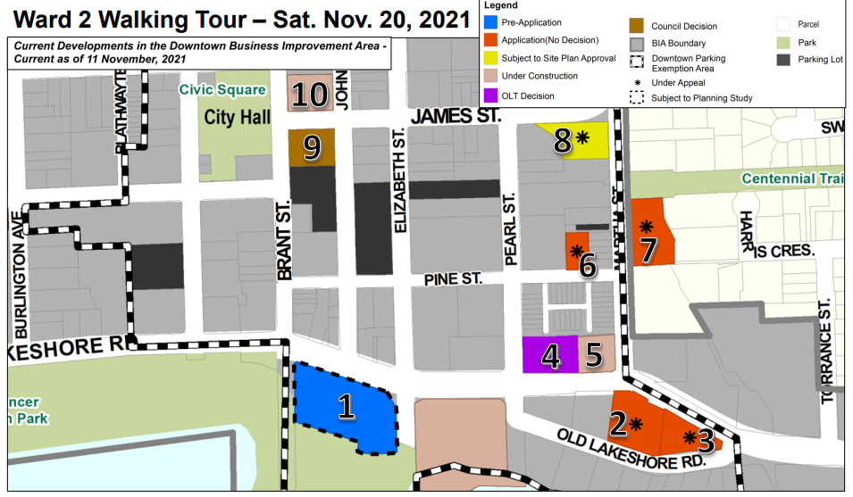 Kearns walkabout stopped at ten development locations in the downtown core, they are as follows: Kearns walkabout stopped at ten development locations in the downtown core, they are as follows:
2020 Lakeshore Rd. Which is in the pre-application phase. It will use a proposed two tall buildings(35-storeys and 30-storeys, as well as a 5-storey podium). It will be used for retail, commercial, and residential space.
Core Development-2093, 2097, 2102 Old Lakeshore td., 2096, 2100 Lakeshore Rd. The application is under appeal. The application is for a 27-storey building consisting of commercial and residential space.
2107 Old Lakeshore Rd. & 2119 Lakeshore Rd. Old Lakeshore Rd. and 2119 Lakeshore Rd. The application is under appeal. The space will be used for a 27-storey building including retail, commercial, and residential space.
2069-2079 Lakeshore Rd. and 383-385 Pearl St. reached an OLT decision. The 29-storey building will host commercial, retail, and residential space.
374 Martha St. The building is under construction. It will be a 26-storey condominium with residential and commercial space.
2085 Pine St. The application is under appeal. It will be an 11-storey building consisting of commercial space, office units, and residential space.
407 Martha St. The application is under appeal. It will be used for an 11-storey residential building.
2082, 2086 and 2090 James St. The location is subject to Site Plan Approval. It will host a 13-storey residential apartment.
409 Brant St. A formal Site Plan Application is being awaited. It will be an 18-storey residential building.
421 Brant St. The unit is under construction. It will be a 23-storey residential, office, and retail building.
 By Pepper Parr By Pepper Parr
November 20th, 2021
BURLINGTON. ON
If you haven’t made your plans for the afternoon – you might want to join Ward 2 Councillor Lisa Kearns on the walkabout she plans in the southern part of her ward.
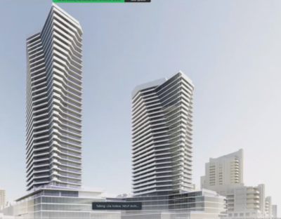 Hear what your ward Councillor has to say about this development – it will replace the Waterfront Hotel. She has invited anyone to join her while she comments on the development proposals that have been grandfathered by the Minister of Municipal Affairs; which means that they will probably clear the Ontario Land Tribunal.
The Mayor has said little and is reported to have done as much as she can to get the members of Council not talk about what the Ministry has done to the city.
You owe it to your self to spend an hour on the walking tour.
Starts at 1:00 pm – gather at the foot of Brant Street at Lakeshore.
 By Pepper Parr By Pepper Parr
November 17th, 2021
BURLINGTON, ON
Information is a little like water: it has its own way of finding the direction in which it wants to flow.
 Minister of Municipal Affairs and Housing – Steve Clark We learn a bit more about what took place and how the Minister of Municipal Affairs did the dirty to the city when he announced the Official move of the Urban Growth Centre and the removal of the MTSA designation to the bus terminal and then added that he was grandfathering seven developments that were within the older Urban Growth Boundary.
That kind of takes the wind out of the Mayor’s sails.
But the woman who won public office on the promise to be transparent and accountable hasn’t been able to make use of those skill sets.
And that promise made during her first election in 2010 when she told a group of her supporters that she wanted their votes but more importantly she wanted their trust.
She got the votes – hard to see where she delivered on the trust part.
We have learned that November 10th was when the decision the Minister made became final. That would suggest that there were ongoing conversations – if they were negotiations – what did Burlington get?
Gazette readers are asking what the city is getting other than the Mayor’s spin that, as one reader put it, goes like this: “Look what I have done, oh, by the way it was too late to stop the high-rise development that will destroy the waterfront”
Ward 2 Councillor Kearns told a resident that she “didn’t receive the actual decision until late on the 11th, then needed some clarity, then the weekend, over to Monday to ensure Council had a chance to review before release.
To be fair to Kearns she did make some rather pithy comments that were part of the media release the city put out. She said:
Ward 2 City Councillor Lisa Kearns “The Minister’s decision may help reduce the long-term development pressure on existing infrastructure and neighbourhoods. On behalf of our residents, I believe there is good reason for concern about the excessive applications already underway. This decision doesn’t fully support the thoughtful and considered conversations we have had to preserve the character of downtown and welcome responsible growth. I understood us to be working towards the same outcome; should the Minister’s decision fail to address this transition issue, it could result in intense pressure for incompatible change.”
Every member of council sat on their hands over this one. How accountable the voters will expect them to be is anyone’s guess.
By Pepper Parr
November 17th, 2021
BURLINGTON, ON
OPINION
We now know a little bit more about the developments that have been grandfathered by the Minister of Municipal Affairs and will proceed through the Ontario Land Tribunal process. If past appeals are any example, they will be approved at that level.
Five years from now Burlington will be a much different city.
A closer look at what has been grandfathered and what they want to build is now possible even though city hall and the Office of the Mayor haven’t had much to say.
It is a different skyline. The degree to which it will change the small, local feel that many people have of Burlington is something that will work itself out if these two towers go up. The Waterfront Hotel site, even though not yet at the application stage has been grandfathered.
The Core Development that runs from one side of the football to the other – from Lakeshore Road on the north to Old Lakeshore Road on the south has been grandfathered.
The development planned for the eastern end of the football, one of the Carriage Gate developments has also been grandfathered.
 This is the structure that will sit right next to Joe Dogs. How that hospitality operation will operate is something that they are certainly thinking really hard about. The development that would be next to Joe Dogs on Brant street – put forward as a 30 storey building has been grandfather as has 407 Martha – a building that is very close to Rambo Creek where part of the retaining wall has been described as not all that safe.
2085 Pine, a property that has changed hands a number of times and been before council with different suggestions on just how much height there could be and at the same time preserve a heritage building at the front of the property – that, too, is at the OLT.
The land between Old Lakeshore Road and Lakeshore Road, known as the football because of its shape was at one time described by former Toronto Mayor David Crombie as a jewel we should not let get away on us.
It became a jewel that developers realized needed a bit of polishing up and then sold off as a very desirable high end property that would never have a building put up between it and the lake.
Somewhere in the last ten years the city was never able to come up with a plan that would secure that land and make it more public space.
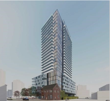 The CORE Development takes up all the land between Old Lakeshore Road and Lakeshore Road in the centre of the football area. The plan is to keep the popular but expensive restaurant that has been on the site for a long time. 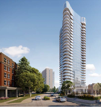 The Carriage Gate people see this development as the eastern gateway into the city. Old Lakeshore Road is to the left with Lakeshore Road to the right. With the grandfathering in place all the planners are left with is the south side of Old Lakeshore Road: Top of bank rules limit what can be done on that land. The heritage designation Emma’s Back Porch has, will limit what can be done with that property.
Once we are out of the pandemic we can expect someone to lease Emma’s and get it back into operation. Not sure how pleasant a local it will be with all the construction that will be taking place.
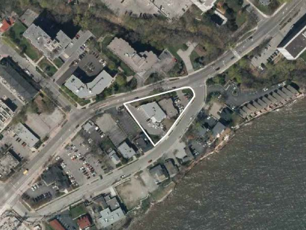 The triangle shaped property will be where Carriage Gate puts up their 25+ tower – they see it as the eastern gateway to the city. The property to the immediate left is where the CORE development will be built. To the left of that is parking across from Emma’s Back Porch which is owned by 2084 Lakeshore Holdings Ltd. They also own the small parking lot to the east of Emma’s. On the western tip of the football the property is owned by a trust – we’ve yet to learn who the beneficiary is of that trust. What does all this leave the city with? Is there nothing more in the way of options?
The pandemic has changed the way citizens can communicate with the elected leadership and that elected leadership hasn’t done all that much to find ways to hear what citizens have to say.
The Office of the Mayor has seen this as an opportunity to put her spin on what has taken place.
Salt with Pepper is the musings, reflections and opinions of the publisher of the Burlington Gazette, an online newspaper that was formed in 2010 and is a member of the National Newsmedia Council.
 By Staff By Staff
November 16th, 2021
BURLINGTON, ON
Update from the City of Burlington on Minister Clark’s decision on Burlington’s Downtown Growth
On Nov. 10, 2021, the City of Burlington received official notification of the boundary adjustment of the City’s Urban Growth Centre (UGC) designation from the Hon. Steve Clark, Minister of Municipal Affairs and Housing. The Minister also confirmed the removal of the Major Transit Station Area (MTSA) designation in the downtown.
This marks an important step in Burlington’s effort to stop the over-development of its historic downtown. The removal of the MTSA designation and boundary adjustment of the UGC takes effect immediately and applies to all new applications. This will help control overdevelopment moving forward.
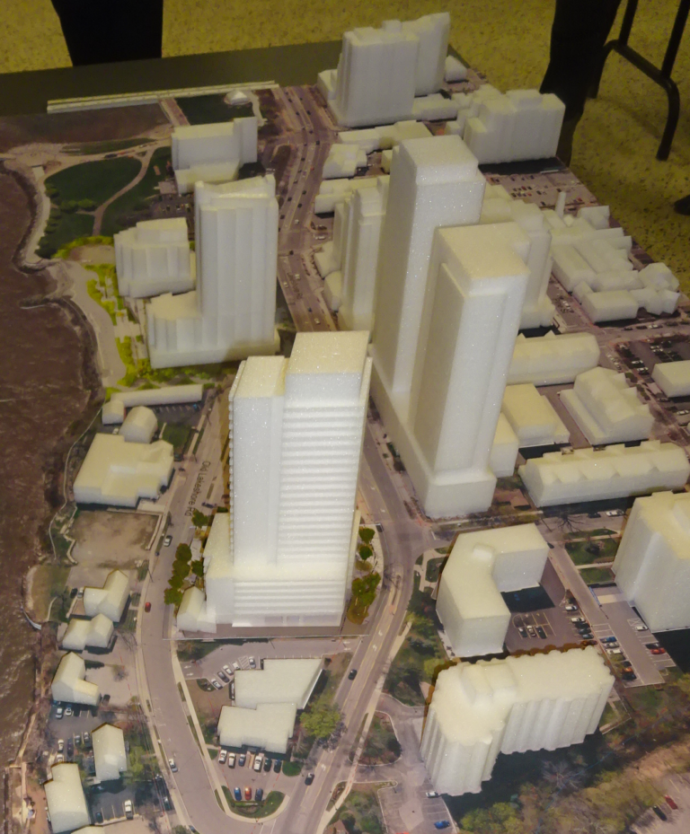 A 3D rendering of some of the development planned, some approved and under construction in and around the the two Lakeshore Roads. However, the Minister chose to grandfather seven applications that were submitted prior to November 10, 2021 from the UGC boundary adjustment and the City is seeking additional clarification on how to proceed.
The changes announced by the Minister were the result of City Council asking the Minister to adjust the UGC boundary and remove the MTSA designation based on Council’s vision for the downtown. As part of the process, the City was required to work with the Region of Halton to make these changes through a Regional Official Plan Amendment (ROPA). The ROPA process involved extensive work and collaboration between the City and Region and consultation with the public.
The immediate adjustment of the UGC boundary and the removal of the MTSA designation will complement provincial transit investments and contribute to the development of sustainable, transit-oriented complete communities in Burlington. These provincial actions also send a clear signal that the scale and intensity of recent development activity in Burlington’s historic downtown was driven by misuse and reliance on the UGC and MTSA and was not sustainable given on-the-ground realities of physical and social infrastructure.
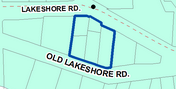 The football is the land between Lakeshore Road and Old Lakeshore Road where intensive development is planned. Five of the seven applications located in Burlington’s downtown are before the Ontario Lands Tribunal and the City will strongly advocate that the tribunal take into account the City’s vision for the downtown and the new changes brought in by the Provincial Government.
 This is the development Carriage Gate wants to build on the eastern end of the football properties The City will defend at every opportunity the vision that this Council has set out and worked tirelessly to have included in the Region’s official plan amendment (ROPA 48). We will encourage proponents of those applications to revaluate their projects given the updated provincial policies.
City of Burlington Council and staff will continue to work with the Hon. Jane McKenna and Minister Clark to see that the pace and scale of development in downtown Burlington is appropriate given the wishes of residents and the availability of infrastructure needed to support it.
This progress is the result of City Council and staff working over the last three years to define the vision for the downtown and see it enshrined in local, regional, and provincial planning policy; this work was done by engaging residents and local businesses who provided clear feedback to Council that the downtown is not the place for large-scale development.
Background
- On Aug. 24, 2020, Burlington City Council unanimously approved requesting the Region of Halton through its Municipal Comprehensive Review of the Regional Official Plan (MCR), to adjust the boundary of the Downtown Urban Growth Centre (UGC) to generally align with the lands in proximity to the Burlington GO Station, and to remove the Major Transit Station Area (MTSA) designation from the Downtown.
- In 2020, the City of Burlington received a joint letter from the Ministry of Municipal Affairs and Housing and Ministry of Transportation stating that the Region of Halton, working together with the City of Burlington, can remove the identification of a mobility hub and the MTSA designation in Downtown Burlington.
- The Interim Control By-law Land Use Study focused on assessing the role and function of the downtown bus terminal and the Burlington GO station as MTSAs, and scoped re-examination of Official Plan policies that focused on the Downtown.
- The Mobility Hubs Study started in 2017-2018 and focused on area-specific planning work for the three GO Station areas: the Aldershot GO, Burlington GO and Appleby GO Major Transit Station Areas (MTSAs). At that time, the City gathered feedback through visioning, public engagement and technical studies. From there, precinct plans were drafted for each study area around the Aldershot, Burlington and Appleby GO Stations.
 Mayor speaking at an event from Spencer Smith Park: How much of the waterfront area is she going to be able to salvage from the Minister’s statement? Mayor Marianne Meed Ward siad in a prepared statement that: “Burlington’s Council was elected with a clear mandate to stop overdevelopment, and we will continue to do everything within our power to do so. The adjustment of the boundaries of the UGC and the MTSA are a victory for good planning in Burlington. However, implementation issues still remain to be resolved. The Minister’s decision that the policies apply only to new applications presents a greater challenge to achieving our vision for downtown with the applications already in. But we remain undaunted in our efforts to keep advocating for the best planning outcome for our community. We thank the Minister and our MPP, Hon. Jane McKenna, for their support on this important work to date, and look forward to their continued support as we seek to achieve the community’s vision for development downtown on all applications before us.”
 Lisa Kearns: Is the Councillor for the ward that is facing just about all of the contentious development on the same page as the Mayor Councillor Lisa Kearns, Ward 2 added to the Mayor’s statement with one of her own, saying: “The Minister’s decision may help reduce the long-term development pressure on existing infrastructure and neighbourhoods. On behalf of our residents, I believe there is good reason for concern about the excessive applications already underway. This decision doesn’t fully support the thoughtful and considered conversations we have had to preserve the character of downtown and welcome responsible growth. I understood us to be working towards the same outcome; should the Minister’s decision fail to address this transition issue, it could result in intense pressure for incompatible change.”
By Pepper Parr
November 13th, 2021
BURLINGTON, ON
OPINION
In the world of politics – getting the right people in the right room at the right time is an art.
Our Mayor may have missed some of those art classes.
 Mayor Meed Ward invited all the members of the OBCM – Ontario Big City Mayors to hold their October 15th meeting in Burlington at the Pearle Hotel and Spa. Mayor Meed Ward invited all the members of the OBCM – Ontario Big City Mayors to hold their October 15th meeting in Burlington at the Pearle Hotel and Spa.
The Gazette didn’t have a lot of information on how that meeting was put together. Neither the Mayor or her staff talk to us. We’ve not been BFF for sometime. But that is another story that will unfold in the fullness of time.
All we knew was that there was a lot for the Mayor to brag about – the locale of the Pearle and its stunning grand stairway and the wide open space overlooking the lake and the Pier would be the envy of any Mayor.
Parts of the meeting were held via Zoom.
Mayor Meed Ward has needed a one-on-one conversation with Steve Clarke, the Minister of Municipal Affairs and Housing for some time. The OBCM event was a perfect opportunity.
The Minister is reported to have said publicly on June 15th of this year that he was on for having the Urban Growth Boundary moved from the location that was agreed upon by the 2014-2018 City Council to something further north and closer to the Burlington GO station.
Meed Ward argued strenuously during the 2018 election that the boundary should have been much closer to the Burlington GO Station to begin with.
Once she was elected as Mayor the first thing she did was fire the City Manager and then began the process of revising the city’s Official Plan that had the Urban Growth Centre moved north.
 Minister of Municipal Affairs Steve Clarke: Mayor hasn’t been able to connect with the Minister – maybe the Minister doesn’t want to talk to her. One of the problems was that there were a number of significant developments that were banking on being part of the UGC – should that be moved they would lose part of their development argument.
All that was needed to make the City and Regional decisions real was the signature from Minister Clarke.
But that signature wasn’t forth coming.
The press conference at which the Minister is reported to have said he was on side for moving the boundary was seriously questioned by a member of the Ontario Land Tribunal who would not accept it into evidence.
One would have thought that a political operative of Meed Ward’s stature would have found a way to set up a one-on-one with Minister Clarke. The OBCM event taking place in Burlington with the group meeting at the spanking new Pearle Hotel and Spa (it is understood that some of the Mayors taking part stayed over at the Hotel) was a perfect place for a conversation.
Having Minister Clarke taking part in the meetings was a natural thing for him to do. He is the Minister of Municipal Affairs and all the biggie municipal Mayors were either attending personally or taking part via Zoom.
But Minister Steve Clarke did not make it to the city on October 15th.
One has to wonder – why a connection wasn’t made. Is Burlington too small for the Minster to pay attention to or is the Mayor just too small a fish for the Minister to make time for?
Or did the Minister realize that there were serious problems with his Ministry and the City and it was better to step around that one. His political advisers would have advised him on that one.
The public is in the dark on just what is going to happen next. Other than blowing off some steam the Mayor didn’t really say all that much. “This is a devastating and shocking decision imposed on our community, which completely disregards the vision of residents, council and staff for this area.
She might have been a little contrite and admit that she really blew this one.
She did add that “Council will be examining all of our options for a review of this OLT decision.
Transparency was a big word when she was a candidate – it didn’t make it into her bag of tricks when she was elected Mayor. How come? Mayor Meed Ward speaks frequently about her experience as a journalist. This would be a good time for her to make herself available to media and be both transparent and accountable and lay all the facts on the table.
Mayor Meed Ward gets in front of the Cogeco cameras as well as the CHCH cameras on a regular basis. They are seen by the Mayor as friendly folk – not the kind of people who ask her tough questions.
Ahmed Hussen, Federal Minister for Housing and Diversity was able to attend Ontario Big City Mayors event.
Why not Minister Clarke?
Related news stories:
The Minister is reputed to have said something about the UGC but there doesn’t appear to be anything in writing
Salt with Pepper is the musings, reflections and opinions of the publisher of the Burlington Gazette, an online newspaper that was formed in 2010 and is a member of the National Newsmedia Council.
 By Pepper Parr By Pepper Parr
November 8th, 2021
BURLINGTON, ON
Bad enough that the two witnesses from the city’s planning department were not on the same page; now we know that the city was fudging some of the material they were presenting and that they tried to argue that a media release, supposedly put out on June 15th amounted to policy.
Worse – the press release was really a transcript of what a planning staff member recalled understanding what the Minister of Municipal Affairs and Housing is reported to have said.
We don’t make this stuff up – it comes out of the written decision released by the OLT Ontario Land Tribunal last week that gave Carriage Gate approval to build a 29 story tower. The decision, which appeared to have surprised Mayor Meed Ward when she said: This is a devastating and shocking decision imposed on our community, which completely disregards the vision of residents, council and staff for this area.
This decision completely dismisses the considerable feedback from residents in opposition to this file – and their valuable suggestions for what would be appropriate. This decision ignored over 100 people who took the time to attend a community meeting, delegate to council, and write pages of letters. There was no acknowledgement of our community’s voice in this decision.
The decision highlights the inappropriate application of Provincial Planning Policies to justify overdevelopment and underscores the importance of a speedy decision from the Minister to remove the Major Transit Station Area designation from downtown and adjust the boundaries of the Urban Growth Centre to the Burlington GO Station, where this scale of development should be. We will continue to work to defend our plan and put growth where it belongs.
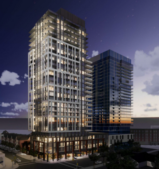 Unless the city can pull a rabbit out of a hat – the building on the lefty is a done deal. The City had argued that on June 15, 2021, the Minister announced that he was moving the location of the Burlington Urban Growth Centre from its existing location to the area surrounding the Burlington GO Station. As a result, the City maintains that the Development is no longer within a UGC area.
The City originally submitted that an adjournment “is required to allow the Parties to provide supplemental witness statements in order for the Tribunal to have the opinions of the expert witnesses on the effect of the subject lands no longer being within a UGC at the time of the Tribunal’s eventual decision in this matter. Without this, the city argued, the Tribunal will not have expert opinion evidence that reflects the policy regime that must be applied to consideration of the applications.
The OLT decision said: “The position taken by counsel for the City and for the Region therefore wholly depends on the contention that a new policy regime was ushered in solely by the Minister’s June 15th oral announcement. This alleged policy pronouncement is claimed to have been captured in an informal transcript filed with the Tribunal – prepared by an unidentified person – of the Minister’s remarks made at the June 15th press conference.
“It appears conceded by the City that the ‘unofficial’ informal transcript that is attached as an exhibit to the sworn Affidavit of the City’s planning witness Mr. Plas is not a complete record of the Minister’s comments made on that occasion. An adequate explanation for this was not offered to the Tribunal.
“Despite the unusual evidentiary basis described above, there seems to be no controversy between the Parties about the main gist of the Minister’s remarks made at this press conference. However, Lakeshore’s (This is the Carriage Gate corporate name for the proposed development on the NE corner of Lakeshore Road and Pearl) counsel adamantly maintains that those verbal comments by the Minister did not and could not constitute the formal lawful introduction of new provincial planning policy.
 For marketing purposes it will be known as Beausoleil For marketing purposes it will be known as Beausoleil
During the time period leading up to the hearings, the Region of Halton adopted ROPA 48 (Regional Official Plan Amendment) on July 7, 2021, which, among other things, reflects the noted change in location of Burlington UGC that was apparently mentioned orally by the Minister on June 15th (although Ms. Yerxa for the Region points out that the prior process leading up to ROPA 48 was of considerable duration and reflected much work and consultation along the way, much of which is contained in the supporting Affidavit of Ms. Poad). ROPA 48 is apparently now before the Ministry for approval.
“However, beyond the remarks of counsel for the City and the Region, there was no evidence to demonstrate that the Ministry will approve it beyond a statement to that effect from Mr. Plas in his Affidavit tendered before the Tribunal. In the Tribunal’s view, this is not proper subject of opinion evidence – it is merely argument, which was repeated in more detail by counsel for the City and the Region at the Motion hearing.”
“In response, the Appellant filed an Affidavit from Mr. Smith, an experienced Planner who challenges the conclusions expressed by Mr. Plas about the effect of the press conference announcement from the Minister and also the allegation that the Minister’s oral announcement was “supportive of ROPA 48”. Again, in the Tribunal’s view, Mr. Smith’s statements are also not proper opinion evidence determinative of this particular issue.
“The Tribunal is unable to accept the contention that the oral remarks made by the Minister at the June 15th press conference, taken alone, constitute the promulgation of new Ontario planning policy by way of an ‘update’ or other ‘revision’ of the Growth Plan in terms of the location of the Burlington It is to be noted that the Minister’s remarks do not specify the precise boundary of this apparent location change, nor do they indicate the effective date of the change. In any event, the Tribunal was not convinced by the City counsel’s submission that no written statement or enactment of the change in the Burlington UGC location is required by law.
Did the City of Burlington get screwed over by the Minister of Municipal Affairs or did he just plain forget what he said he would do? “Neither Counsel for the City or the Region could cite any jurisprudence specifically on this point to support this unique argument. Moreover, in the Tribunal’s view this notion seems counter-intuitive in light of the very detailed provincial planning regime currently in force. The Tribunal specifically disagrees that the Minister’s remarks described above can be treated as a lawful, formal issuance of Provincial policy within the meaning of s. 1, 2 and 3 of the Planning Act.
“The Tribunal also agrees with Lakeshore’s counsel that for the purposes of this appeal the relevant provincial policy provisions include those set out in the current Provincial Policy Statement (PPS) and the current GP. The Tribunal thus rejects the contention that the current GP has somehow been changed or ‘updated’ in relation to the location of the Downtown Burlington UGC by reason either of the June 15, 2021 oral comments of the Minister or the content of the draft ROPA 48 which has not been approved by the Province.
“The Tribunal is of the opinion that the City’s proposition that a hearing should be adjourned to deal with anticipated possible future changes in provincial policy is:
(a) without foundation and without case law authority;
(b) amounts to a repudiation of long-established jurisprudence since it requires the evaluation of planning applications on the basis of alleged “emerging” policy intended to signal a new evolution of priorities for intensification in the City; and
(c) is highly unusual given that the very notion of modifying the UGC boundary in the City was not introduced until nearly 2 years after the Appellant’s applications were deemed complete by the City.
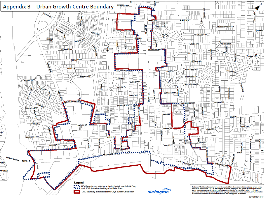 This is the Urban Growth Boundary that Mayor Meed Ward fought hard to have changed. She thought she had – the Minister of Municipal Affairs said he would approve but had not yet signed the decision. So, legally it has not been changed and the Beausoleil development get the go ahead from the Ontario Land Tribunal  Nick Carnecelli had a stronger case and lawyers who knew what was acceptable in terms of evidence – something the city didn’t have . The Tribunal also agrees with the submission of counsel for the Appellant that:
“the press conference statement itself goes no further than suggesting the Minister “will be moving” the UGC, not that it already has been moved. This is a statement of possible future intention and nothing more. It provides no indication of how or when. It does not discuss implementation at all. There is no reference to ROPA 48 despite the statement of Mr. Plas. It refers to “long-term planning” as opposed to immediate effect”.
As a final matter, the Tribunal further disagrees with the argument of the City’s counsel that the purposes and policies underlying the Tribunal’s Rules of Practice and Procedure in any way require the granting of the City’s adjournment motion in the unique circumstances of this case, and the Tribunal declines to exercise its discretion to do so.
What does all this mean? First that the city is made to look like a couple of high school students screwing things up.
Secondly, it leaves the Mayor with a problem with the OLT decision, which, try as she might, is likely to hold.
This piece of land and the site of the Waterfront Hotel will be the next battle ground. Then there is the north side of Lakeshore Road from Brant to Martha that will get the developer treatment. What impact is the decision going to have on the several development across the street in a piece of land known as the football where there are two developments working their way through the application process and at least two properties within the football that do not have any development activity ongoing.
Mayor Meed Ward had put everything on getting the Urban Growth Centre Boundary moved and she thought she had it done.
Both Planning and Legal are responsible for this one.
How many more like it are there out there?
Related news story.
City planner described as not an expert witness in OLT decision.
|
|


